
Sonar is a technique that uses sound propagation to navigate, measure distances (ranging), communicate with or detect objects on or under the surface of the water, such as other vessels.

A time-domain reflectometer (TDR) is an electronic instrument used to determine the characteristics of electrical lines by observing reflected pulses. It can be used to characterize and locate faults in metallic cables , and to locate discontinuities in a connector, printed circuit board, or any other electrical path.
In telecommunications, signal reflection occurs when a signal is transmitted along a transmission medium, such as a copper cable or an optical fiber. Some of the signal power may be reflected back to its origin rather than being carried all the way along the cable to the far end. This happens because imperfections in the cable cause impedance mismatches and non-linear changes in the cable characteristics. These abrupt changes in characteristics cause some of the transmitted signal to be reflected. In radio frequency (RF) practice this is often measured in a dimensionless ratio known as voltage standing wave ratio (VSWR) with a VSWR bridge. The ratio of energy bounced back depends on the impedance mismatch. Mathematically, it is defined using the reflection coefficient.
A trench is a type of excavation or depression in the ground that is generally deeper than it is wide, and narrow compared with its length.

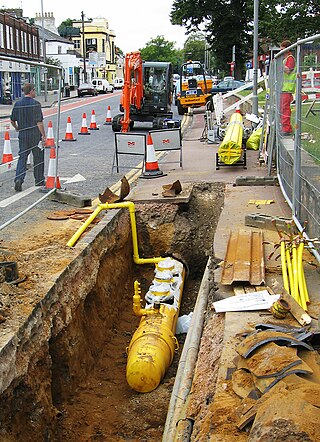
Utility location is the process of identifying and labeling public utility mains that are underground. These mains may include lines for telecommunication, electricity distribution, natural gas, cable television, fiber optics, traffic lights, street lights, storm drains, water mains, and wastewater pipes. In some locations, major oil and gas pipelines, national defense communication lines, mass transit, rail, and road tunnels also compete for space underground.
Acoustic homing is the process in which a system uses the sound or acoustic signals of a target or destination to guide a moving object. There are two types of acoustic homing: passive acoustic homing and active acoustic homing. Objects using passive acoustic homing rely on detecting acoustic emissions produced by the target. Conversely, objects using active acoustic homing make use of sonar to emit a signal and detect its reflection off the target. The signal detected is then processed by the system to determine the proper response for the object. Acoustic homing is useful for applications where other forms of navigation and tracking can be ineffective. It is commonly used in environments where radio or GPS signals can not be detected, such as underwater.
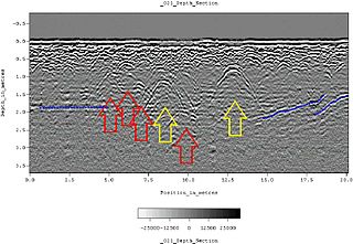
Ground-penetrating radar (GPR) is a geophysical method that uses radar pulses to image the subsurface. It is a non-intrusive method of surveying the sub-surface to investigate underground utilities such as concrete, asphalt, metals, pipes, cables or masonry. This nondestructive method uses electromagnetic radiation in the microwave band of the radio spectrum, and detects the reflected signals from subsurface structures. GPR can have applications in a variety of media, including rock, soil, ice, fresh water, pavements and structures. In the right conditions, practitioners can use GPR to detect subsurface objects, changes in material properties, and voids and cracks.

A security alarm is a system designed to detect intrusions, such as unauthorized entry, into a building or other areas, such as a home or school. Security alarms protect against burglary (theft) or property damage, as well as against intruders. Examples include personal systems, neighborhood security alerts, car alarms, and prison alarms.

Demining or mine clearance is the process of removing land mines from an area. In military operations, the object is to rapidly clear a path through a minefield, and this is often done with devices such as mine plows and blast waves. By contrast, the goal of humanitarian demining is to remove all of the landmines to a given depth and make the land safe for human use. Specially trained dogs are also used to narrow down the search and verify that an area is cleared. Mechanical devices such as flails and excavators are sometimes used to clear mines.

Acoustic location is a method of determining the position of an object or sound source by using sound waves. Location can take place in gases, liquids, and in solids.

A lightning detector is a device that detects lightning produced by thunderstorms. There are three primary types of detectors: ground-based systems using multiple antennas, mobile systems using a direction and a sense antenna in the same location, and space-based systems. The first such device was invented in 1894 by Alexander Stepanovich Popov. It was also the first radio receiver in the world.
In an electric power system, a fault or fault current is any abnormal electric current. For example, a short circuit is a fault in which a live wire touches a neutral or ground wire. An open-circuit fault occurs if a circuit is interrupted by a failure of a current-carrying wire or a blown fuse or circuit breaker. In three-phase systems, a fault may involve one or more phases and ground, or may occur only between phases. In a "ground fault" or "earth fault", current flows into the earth. The prospective short-circuit current of a predictable fault can be calculated for most situations. In power systems, protective devices can detect fault conditions and operate circuit breakers and other devices to limit the loss of service due to a failure.
Distributed temperature sensing systems (DTS) are optoelectronic devices which measure temperatures by means of optical fibres functioning as linear sensors. Temperatures are recorded along the optical sensor cable, thus not at points, but as a continuous profile. A high accuracy of temperature determination is achieved over great distances. Typically the DTS systems can locate the temperature to a spatial resolution of 1 m with accuracy to within ±1 °C at a resolution of 0.01 °C. Measurement distances of greater than 30 km can be monitored and some specialised systems can provide even tighter spatial resolutions. Thermal changes along the optical fibre cause a local variation in the refractive index, which in turn leads to the inelastic scattering of the light propagating through it. Heat is held in the form of molecular or lattice vibrations in the material. Molecular vibrations at high frequencies (10 THz) are responsible for Raman scattering. Low frequency vibrations (10–30 GHz) cause Brillouin scattering. Energy is exchanged between the light travelling through the fibre and the material itself and cause a frequency shift in the incident light. This frequency shift can then be used to measure temperature changes along the fibre.
Islanding is the intentional or unintentional division of an interconnected power grid into individual disconnected regions with their own power generation.
An optical ground wire is a type of cable that is used in overhead power lines. Such cable combines the functions of grounding and communications. An OPGW cable contains a tubular structure with one or more optical fibers in it, surrounded by layers of steel and aluminum wire. The OPGW cable is run between the tops of high-voltage electricity pylons. The conductive part of the cable serves to bond adjacent towers to earth ground, and shields the high-voltage conductors from lightning strikes. The optical fibers within the cable can be used for high-speed transmission of data, either for the electrical utility's own purposes of protection and control of the transmission line, for the utility's own voice and data communication, or may be leased or sold to third parties to serve as a high-speed fiber interconnection between cities.

Stray voltage is the occurrence of electrical potential between two objects that ideally should not have any voltage difference between them. Small voltages often exist between two grounded objects in separate locations by the normal current flow in the power system. Contact voltage is a better defined term when large voltage appear as a result of a fault. Contact voltage on the enclosure of electrical equipment can appear from a fault in the electrical power system, such as a failure of insulation.

An underground power line provides electrical power with underground cables. Compared to overhead power lines, underground lines have lower risk of starting a wildfire and reduce the risk of the electrical supply being interrupted by outages during high winds, thunderstorms or heavy snow or ice storms. An added benefit of undergrounding is the aesthetic quality of the landscape without the powerlines. Undergrounding can increase the capital cost of electric power transmission and distribution but may decrease operating costs over the lifetime of the cables.
Pipeline leak detection is used to determine if a leak has occurred in systems which contain liquids and gases. Methods of detection include hydrostatic testing, tracer-gas leak testing, infrared, laser technology, and acoustic or sonar technologies. Some technologies are used only during initial pipeline installation and commissioning, while other technologies can be used for continuous monitoring during service.
Subsurface utility engineering (SUE) refers to a branch of engineering that involves managing certain risks associated with utility mapping at appropriate quality levels, utility coordination, utility relocation design and coordination, utility condition assessment, communication of utility data to concerned parties, utility relocation cost estimates, implementation of utility accommodation policies, and utility design.

Detectable tape or Underground warning tape is a conductive tape typically applied over buried utilities made of non-conductive materials such as plastic, fiberglass, or cement. It is used because most utility location methods work best on conductive objects, and hence may easily miss structures made of non-conductive materials.

