Cadair Fawr

Last updated

Cadair Fawr is a hill in the northern corner of the county borough of Rhondda Cynon Taf, Wales. It lies within the Brecon Beacons National Park and Fforest Fawr Geopark. The 485m high summit at OS grid ref SN 978123 is marked by a trig point. Cadair Fawr is the highest point of a broad ridge known as Cefn Cadlan which forms the northern edge of Cwm Cadlan, a valley which itself runs east-northeastwards from the village of Penderyn. The name Cadair Fawr signifies the 'big chair' whilst Cefn Cadlan signifies the 'ridge of the battlefield'. [1]

Contents

Geology

The summit is formed from Carboniferous Limestone whilst much of the Cefn Cadlan ridge which slopes away to the west is formed from the Twrch Sandstone (formerly known as the Basal Grit), which also dates from the Carboniferous period. A series of minor faults runs northwest to southeast through the hill whilst a few including the Coed Hir Fault run northeast to southwest, paralleling the major fault forming a part of the Neath Disturbance which runs through Cwm Cadlan. Much of the hill's surface is pitted by shakeholes, the larger of which occur on the areas where gritstone forms the surface. Quarries have been opened up in both the limestone and the gritstone over the years though none are now active. [2]

Scheduled ancient monuments

Cadair Fawr Round Cairn
( 51°47′57″N3°29′04″W / 51.7992°N 3.4844°W / 51.7992; -3.4844 (Cadair Fawr Round Cairn) , OS grid ref: SN977122.) A large cairn, 9m across, near the summit of Cadair Fawr (also sometimes spelled Cader Fawr Round Cairn). [3]
Pant-y-Gadair Hut Circle Settlement
( 51°48′18″N3°28′19″W / 51.8049°N 3.4719°W / 51.8049; -3.4719 (Pant-y-Gadair Hut Circle Settlement) , OS grid ref: SN98612.) A prehistoric hut circle 6m across, with walls of unworked limestone, on the north slopes of Cadair Fawr. [4]
Cadair Fawr settlement
( 51°47′57″N3°28′19″W / 51.7993°N 3.472°W / 51.7993; -3.472 (Cadair Fawr settlement) , OS grid ref: SN985122) - A group of medieval or later house platforms east of the summit of Cadair Fawr. [5]

Access

The hill is designated as open country so freely available to walkers. It is readily accessed from the A4059 road which runs along its northern edge between Hirwaun and the A470 road south of Storey Arms.

See also

List of Scheduled Monuments in Rhondda Cynon Taf

Related Research Articles

<span class="mw-page-title-main">Mynydd Marchywel</span>

Mynydd Marchywel is a 418-metre (1,371 ft) high hill in the Neath Port Talbot area in South Wales. Its summit is marked both by a cairn and a trig point. The larger part of the hill is cloaked in modern forestry through which numerous streams fall away westward to the River Tawe, eastward to the River Dulais and southward into the Clydach, the latter two being tributaries of the River Neath.

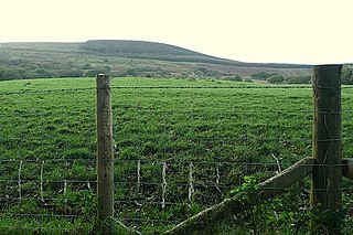
Hirfynydd is a 481-metre-high hill in Neath Port Talbot county borough in South Wales. A Roman road, Sarn Helen, runs along its entire northeast–southwest ridge-line, a route followed by a modern-day byway. To its west is Cwm Dulais and to its southeast is the Vale of Neath. The northern end of the ridge falls away to a broad upland vale containing the Afon Pyrddin and beyond which is the Brecon Beacons National Park.

<span class="mw-page-title-main">St Brides Major (community)</span> Human settlement in Wales

St Brides Major is a community on the western edge of the Vale of Glamorgan, South Wales. Its largest settlement is the village of St Brides Major, and also includes the villages of Ogmore-by-Sea and Southerndown, and the hamlets of Ogmore Village, Castle-upon-Alun, Heol-y-Mynydd, Norton and Pont-yr-Brown It is notable for coastal geology and scenery, limestone downlands and fossilised primitive mammals, sea cliffs and beaches, two Iron Age hillforts, three medieval castle sites,, two stepping stone river crossings and a clapper bridge. Three long distance paths cross the community. It is the western limit of the Vale of Glamorgan Heritage Coast, and has a visitor centre and tourist facilities.

References

  1. Ordnance Survey Explorer map OL12 'Brecon Beacons National Park: western area'
  2. British Geological Survey 1:50,000 map sheet 231 'Merthyr Tydfil' & accompanying memoir
  3. coflein NPRN: 84644. GGAT PRN: 00743m. Cadw SAM: BR135: Cader Fawr Round Cairn
  4. coflein NPRN: 84685. GGAT PRN: 02048m. Cadw SAM: BR413: Pant-y-Gadair Hut Circle Settlement
  5. coflein NPRN: 84653. GGAT PRN: 00750m. Cadw SAM: GM559: Cadair Fawr settlement

51°48′00″N3°29′01″W / 51.7999°N 3.4836°W / 51.7999; -3.4836