
Xunantunich is an Ancient Maya archaeological site in western Belize, about 70 miles (110 km) west of Belize City, in the Cayo District. Xunantunich is located atop a ridge above the Mopan River, well within sight of the Guatemala border – which is 0.6 miles (1 km) to the west. It served as a Maya civic ceremonial centre to the Belize Valley region in the Late and Terminal Classic periods. At that time, when the region was at its peak, nearly 200,000 people lived in the Belize Valley.
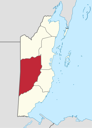
Cayo District is a district located in the west part of Belize. It is the most extensive, second-most populous and third-most densely populated of the six districts of Belize. The district's capital is the town of San Ignacio.
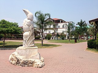
San Ignacio and Santa Elena are towns in western Belize. San Ignacio serves as the cultural-economic hub of Cayo District. It got its start from mahogany and chicle production during British colonisation. Over time it attracted people from the surrounding areas, which led to the diverse population of the town today. San Ignacio is the largest settlement in Cayo District and the second largest in the country, after Belize City.

St. George's Caye is an island in the Caribbean Sea, eight miles east of Belize City. It is part of the Belize District of Belize, Central America. The village on the island is also known as St. George's Caye. As of 2000, St. George's Caye had a permanent population of about 20 people.

Cahal Pech is a Maya site located near the town of San Ignacio in the Cayo District of Belize. The site was a palatial, hilltop home for an elite Maya family, and though the most major construction dates to the Classic period, evidence of continuous habitation has been dated to as far back as 1200 BCE during the Early Middle Formative period, making Cahal Pech one of the oldest recognizably Maya sites in Western Belize.
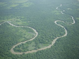
The Belize River runs 290 kilometres (180 mi) through the center of Belize. It drains more than one-quarter of the country as it winds along the northern edge of the Maya Mountains to the sea just north of Belize City. The Belize river valley is largely tropical rainforest.

Actun Tunichil Muknal, also known locally as ATM, is a cave in Belize, near San Ignacio, Cayo District, notable as a Maya archaeological site that includes skeletons, ceramics, and stoneware. There are several areas with skeletal remains in the main chamber. The best known is "The Crystal Maiden", the skeleton of what is believed to be a 17-year-old boy, possibly a sacrifice victim, whose bones have been calcified to a sparkling, crystallized appearance.
Belize Botanic Gardens (BBG) is 45 acres (18 ha) of native and exotic plants growing in the Cayo district of western Belize. The garden is in a valley on the banks of the Macal River, surrounded by the Maya Mountain foothills.

The Macal River is a river running through Cayo District in western Belize. Sites along the river include the ancient Mayan town of Cahal Pech and the Belize Botanic Gardens. The Macal River discharges into the Belize River. There are several tributaries to the Macal River including the following streams: Privassion, Rio On, Rio Frio, Mollejon and Cacao Camp.

Chaa Creek is a tributary of the Macal River in the Cayo District in western Belize. One of the official gauging stations of the Macal is located near the confluence with Chaa Creek.
San Ignacio Resort Hotel is a hotel resort on Buena Vista Street, San Ignacio, Cayo District, Belize. It is located just off of the Western Highway, above the Macal River valley. It contains the Running W Steak House, The Stork Club and bar, and the Princess Casino. The hotel is popular with archaeologists working in the vicinity.
The Lodge at Chaa Creek is an eco-resort and 400-acre private nature reserve located in the Cayo District of Belize, Central America. Established as a small family farm in 1981, it has grown to be one of Belize’s most recognized resorts. It has also received international recognition as a model for sustainable tourism and responsible travel by Conde Nast, National Geographic Adventure, Travel and Leisure magazines, and other publications and organizations. Chaa Creek runs educational and natural history programs with a focus on Belize's Maya culture and civilization.
Pook's Hill is a private forest reserve, bird sanctuary, and archaeological site in Cayo District, Belize, 12 miles (19 km) west of Belmopan. The Mayan site contains temples, a plazuela, midden, banquet hall, and burial sites. Facilities within the reserve include Pook's Hill Lodge, an ecotourism resort.
Lower Dover is a Maya archaeological site in the Belize River Valley. It is located on the grounds of the Lower Dover Field Station & Jungle Lodge, in Unitedville, Cayo District, Belize. The site is bordered by the Belize River to the north, Upper Barton Creek to the west, Lower Barton Creek to the east, and the Western Highway to the south. Lower Dover is one of several Maya archaeological sites in the area; it is across the Belize River from Barton Ramie, 3 kilometers west of Blackman Eddy, and 6 kilometers east of Baking Pot.
Jaime José Awe is a Belizean archaeologist who specializes in the ancient Maya, a Professor of Anthropology at Northern Arizona University, and the Director of the Belize Valley Archaeological Reconnaissance Project.
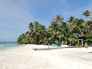
Ranguana Caye is a private island with a total area of two acres, approximately 20 miles west of Placencia, Belize. The island harbours a dock and moorings for visiting boats which is located just off the Belize Barrier Reef. Tours are available through the Belize Ocean Club, a resort located in Maya Beach Village near Placencia and managed by Muy'Ono Properties. Snorkeling and reef fishing are also some activities available on the island.
Branch Mouth is a village in the Cayo District of central interior Belize. It is situated north of San Ignacio and named for its placement near the confluence of the Macal and Mopan Rivers where the Belize River is formed. The village is in an agricultural region with the most frequent crops being citrus and banana. It is one of 192 municipalities administered at the village level in the country for census-taking purposes.
Duck Run I, or alternatively Duck Run 1, is a village in the Cayo District of central interior Belize. The village is in an agricultural region with the most frequent crops being citrus and banana. It is one of 192 municipalities administered at the village level in the country for census taking purposes. The village had a population of 663 in 2010. This represents roughly 1% of the district's total population. No census record was taken for the village in 2000. Duck Run I is one of three recognized municipalities with the name "Duck Run" south of Spanish Lookout having its own local government representation. The other two communities are Duck Run II and Duck Run III.
Duck Run II, alternatively known as Duck Run 2, is a village in the Cayo District of central interior Belize. The village is in an agricultural region with the most frequent crops being citrus and banana. It is one of 192 municipalities administered at the village level in the country for census taking purposes. The village had a population of 370 in 2010. This represents roughly 0.6% of the district's total population. No census record was taken for the village in 2000. Duck Run II is one of three recognized municipalities with the name "Duck Run" south of Spanish Lookout having its own local government representation. The other two communities are Duck Run I and Duck Run III.
Duck Run III, alternatively known as Duck Run 3, is a village in the Cayo District of central interior Belize.The village is in an agricultural region where the most common crops are citrus and banana. It is one of 192 village level municipalities for census purposes. The village had a population of 400 in 2010. This represents roughly 0.6% of the district's total population. No census record was taken for the village in 2000. Duck Run III is one of three recognized municipalities with the name "Duck Run" south of Spanish Lookout having its own local government. The other two communities are Duck Run I and Duck Run II.
