
The Grampian Mountains are one of the three major mountain ranges in Scotland, occupying a considerable portion of the Scottish Highlands in northern Scotland. The other major mountain ranges in Scotland are the Northwest Highlands and the Southern Uplands. The Grampian range extends southwest to northeast between the Highland Boundary Fault and the Great Glen, occupying almost half of the land area of Scotland and including the Cairngorms and the Lochaber hills. The range includes many of the highest mountains in the British Isles, including Ben Nevis and Ben Macdui.
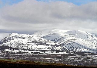
Ben Macdui is the second highest mountain in Scotland after Ben Nevis, and the highest in the Cairngorms National Park. The summit elevation is 1,309 meters AMSL. Ben Macdui lies on the southern edge of the Cairn Gorm plateau, on the boundary between the historic counties of Aberdeenshire and Banffshire.

The East Neuk or East Neuk of Fife is an area of the coast of Fife, Scotland.

The Ochil Hills (; Scottish Gaelic: Monadh Ochail is a range of hills in Scotland north of the Forth valley bordered by the towns of Stirling, Alloa, Kinross, Auchterarder and Perth. The only major roads crossing the hills pass through Glen Devon/Glen Eagles and Glenfarg, the latter now largely replaced except for local traffic by the M90 Edinburgh-Perth motorway cutting through the eastern foothills. The hills are part of a Devonian lava extrusion whose appearance today is largely due to the Ochil Fault which results in the southern face of the hills forming an escarpment. The plateau is undulating with no prominent peak, the highest point being Ben Cleuch at 721 m. The south-flowing burns have cut deep ravines including Dollar Glen, Silver Glen and Alva Glen, often only passable with the aid of wooden walkways.

Aonach Mòr is a mountain in the Highlands of Scotland. It is located about 2 miles north east of Ben Nevis on the south side of Glen Spean, near the town of Fort William. The Nevis Range ski area is located on the northern slopes of the peak; the use of this name has inspired some controversy, as it has been considered by some to represent a deliberate changing of an indigenous name.

Lordscairnie Castle is a ruin situated near Moonzie, 2.5 miles (4.0 km) north-east of Cupar, in Fife, Scotland. It is protected as a scheduled monument.

Norman's Law is a prominent hill at the far eastern end of the Ochil Fault, Scotland. It sits above the south bank of the River Tay, around four miles north west of Cupar.

The Lomond Hills, also known outwith the locality as the Paps of Fife, are a range of hills in central Scotland. They lie in western central Fife and Perth and Kinross, Scotland. At 522 metres (1,713 ft) West Lomond is the highest point in the county of Fife.

West Lomond is the highest point in the county of Fife, Scotland and the highest peak in the Lomond Hills. Its cone-shaped summit, which is the remains of a volcanic plug, rises above an escarpment of Carboniferous sandstone and limestone layers, capped with a quartz-microgabbro sill. The conspicuous peaks of West Lomond, and its neighbour East Lomond, are visible for many miles around, which explains one suggested origin of their name, the 'Lomond' or 'beacon' hills. On the summit are the remains of an Iron Age hill fort.

Morrone is a Scottish hill immediately southwest of the village of Braemar in Aberdeenshire.

Kemback is a village and parish in Fife, Scotland, located 2.5 miles (4.0 km) east of Cupar. The present village was developed in the 19th century to house those working the flax mills on the nearby Ceres Burn. From 1681 the minister for the parish was Alexander Edward, until 1689 when he was deprived as a non-juror. He went on to become an architect and landscape architect, working on schemes for Brechin Castle and Hamilton Palace.
Gowrie is a region and ancient province of Scotland, covering the eastern sliver of what became Perthshire. It was located to the immediate east of Atholl, and originally included the area around Perth, though that was later detached as Perthia.

Dunfermline was a local government district in the Fife region of Scotland from 1975 to 1996, lying to the south-west of the regional capital Glenrothes.

Kirkcaldy was a local government district in the Fife region of Scotland from 1975 to 1996, lying a short distance to the south of the regional capital Glenrothes which lay within the district.

Benarty is the name which is informally and commonly used to refer to the ex-mining towns of Ballingry and Lochore and the villages of Crosshill, Lochcraig and Glencraig. The area is situated north of Lochgelly, Fife. The name comes from Benarty Hill, locally simply Benarty, a prominent local landmark, at 356m high.
Dunbog is a parish in the county of Fife in Scotland. The name of the parish derives from the Scottish Gaelic, Dùn Bolg, meaning "bag fort" or "bag-like, rounded hill". The parish is of entirely rural character, with no actual village - only a collection of farm houses. Dunbog parish is bounded on the north by the River Tay, on the south by Monimail, on the east by Flisk and Creich, and on the west by Abdie. The Barony of Denboig/Dunbog was established in 1687. The nearest town of any size is Newburgh. It has a small primary school.
Creich, is a hamlet in Fife, Scotland. The local parish is named after Creich. The ruins of Creich Castle are located nearby.

Cults is a small parish in the centre of the County of Fife, Scotland. The name of the village derives from the Scottish Gaelic cùilt meaning a corner or recess. It lies mainly in the Howe of Fife, and about 4 1⁄2 miles (7.2 km) south-west of Cupar. The parish is about 2 1⁄3 miles (3.8 km) long and 1 1⁄3 miles (2.1 km) wide. It contains various villages and hamlets including Cults, Ladybank, Kingskettle, Kettlebridge, Pitlessie, Collessie, Crossgates and Walton. The Church of Scotland has now included Cults in the wider "Howe of Fife Parish" which has the churches of Ladybank, Cults, Kettle and Collessie. The only archaeological site of any importance seems to be a fort on the western slope of Walton Hill.

Orwell is a parish in Kinross-shire, Scotland. It contains the market town of Milnathort, as well as the hamlet of Middleton. The name comes from the Gaelic iubhar coille meaning "yew wood".

Raith, as an area of Fife, once stretched from the lands of Little Raith, south of Loch Gelly, as far as Kirkcaldy and the Battle of Raith was once theorised to have been fought here in 596 AD. Raith Hill, west of Auchtertool and immediately to the east of the Mossmorran fractionation plant, may also be in reference to this wider area or may refer to an actual fort on this hill, distinct to the one naming the area.


