Cais da Alfândega (Angra do Heroísmo)

Last updated
Wharf of the Customshouse
Cais da Alfândega

Baia dAngra (1708846731).jpg

A ground view of the marina and docks of Cais da Alfândega, showing the customshouse (left) and the Church of the Misericórdia (right)
Location
Location , Angra do Heroísmo (Azores), Portugal
Coordinates 38°39′13″N27°13′06″W / 38.653681°N 27.218255°W / 38.653681; -27.218255 Coordinates: 38°39′13″N27°13′06″W / 38.653681°N 27.218255°W / 38.653681; -27.218255
Details
Owner Câmara Municipal de Angra do Heroísmo
Operator Portos dos Açores
Opened 15th century
Type Wet dock/Marina/Docks

The Wharf of the Customshouse (Portuguese : Cais da Alfândega) is located on the edge of the Bay of Angra, in the civil parish of , municipality of Angra do Heroísmo, on the island of Terceira, Portuguese archipelago of the Azores.

Portuguese language Romance language that originated in Portugal

Portuguese is a Western Romance language originating in the Iberian Peninsula. It is the sole official language of Portugal, Brazil, Cape Verde, Guinea-Bissau, Mozambique, Angola, and São Tomé and Príncipe. It also has co-official language status in East Timor, Equatorial Guinea and Macau in China. As the result of expansion during colonial times, a cultural presence of Portuguese and Portuguese creole speakers are also found in Goa, Daman and Diu in India; in Batticaloa on the east coast of Sri Lanka; in the Indonesian island of Flores; in the Malacca state of Malaysia; and the ABC islands in the Caribbean where Papiamento is spoken, while Cape Verdean Creole is the most widely spoken Portuguese-based Creole. A Portuguese-speaking person or nation may be referred to as "Lusophone" in both English and Portuguese.

Bay of Angra

Bay of Angra is a natural bay within the coastal extent of the municipality of Angra do Heroísmo, on the Portuguese island of Terceira in the archipelago of the Azores. Within an average depth of 40 metres (130 ft), the bay has been of historical importance to the island; since the 15th century, it was a port-of-call for returning merchant shipping from the East Indies and Brazil, laden with gold, silver, porcelain, spices, rare woods, and other goods. These ships would anchor in the Bay of Angra until supported by armed escorts, which would accompany the ships on the rest of their voyage to Portugal. The Bay at Angra provided shelter from northern and northwestern winds; only storms originating to the south or southeast, posed a threat. Nonetheless, the Bay is the final resting-place of several ships affected by the adverse winds: local archives and a rich oral tradition supports the foundering of many ships against the leeward shore.

Sé (Angra do Heroísmo) Civil Parish in Azores, Portugal

is a parish in the municipality of Angra do Heroísmo on the island of Terceira in the Azores. The population in 2011 was 955, in an area of 1.65 km². It is one of the smallest parishes in Angra do Heroísmo.

Contents

History

A view of the marina that now occupies the former Cais da Alfandega along the coast Baia de Angra do Heroismo e igreja da Misericordia, ilha Terceira, Acores, Portugal.JPG
A view of the marina that now occupies the former Cais da Alfândega along the coast
The modern marina and wharf constructed in the 20th century Portugal Azores Terceira island (542979851).jpg
The modern marina and wharf constructed in the 20th century

The anchorage is the oldest wharf in Angra do Heroísmo, established after the first settlers began arriving between 1470 and 1500, at the time when Álvaro Martins Homem promoted its colonization. This wharf connected directly through the city gates to the Pátio da Alfândega (Customhouse's Patio/Veranda), the hospital of the Misericórdia (along the Rua de Santo Espírito) and the building from which goods were registered and warehoused for the town. Many of the boats that transited the waters of the North Atlantic passed through Angra on their way to and from the colonies of North and South America.

Álvaro Martins Portuguese explorer

Álvaro Martins, also known as Álvaro Martins Homem, was a 15th-century Portuguese alleged to have explored the western Atlantic and later the African coast. He is claimed to have accompanied João Vaz Corte-Real on an undocumented expedition to Terra Nova do Bacalhau in the early 1470s, by Gaspar Frutuoso in his 1570s book Saudades da Terra.

The oldest view of the old wharf was characterized in an engraving of the port around 1590, showing the anchorage alongside Monte Brasil. At that time, the ravine that flowed into the bay allowed naval repair, with its access along Rua de São João. Along Rua Direita a fortified passage existed that canalized the ravine's water to the port, where they supported naval ships.

Monte Brasil mountain in Portugal

Monte Brasil is the remnants of a tuff volcano connecting the south coast of Terceira in the central Azores, overlooking the city of Angra do Heroísmo. Monte Brasil is flanked by two bays: the Bay of Angra to its east, and the Bay of Fanal to its west, and was used as a defensive point during the history of Angra, resulting in the construction of various forts and redoubts, including the Fortress of São João Baptista overlooking the city.

For the following century little is known. It was the main hub for customs traffic, and the city gates acted as a symbol of the city's commercial authority. Repairs to the wharf were carried out in 1610, and the gates became a representation of the commercial power of the town, as it was an obligatory stop in trans-Atlantic traffic. The customhouse patio, which encircles the building in the east and south, helped businessmen, providing a line-of-sight to goods offloaded from shipping docked at the wharf.

Customshouse of Angra do Heroísmo

The Customhouse of Angra do Heroísmo is a well-preserved Portuguese custom house located in the civil parish of Sé, in the municipality of Angra do Heroísmo, in archipelago of the Azores.

The fortified gates also served as a protective structure since the middle of the 16th century, when it was integrated into the massive coastal defenses of Monte Brasil, along with the Fort of São Sebastião (to the east), the Fort of São Benedito and later the Fort of Santo António (to the west), which were ordered constructed by the Provisioner of Arms Pero Anes do Canto. The gate lasted 250 years, until an earthquake on 1 November 1755 (an aftershock of the 1755 Lisbon earthquake) caused a wave that inundated buildings until the old square (Portuguese : Praça Velha). The waters destroyed and dragged the structure.

Pero Anes do Canto (1480–1556) was a Portuguese nobleman, who was born at Guimarães, Portugal and died at Angra do Heroísmo, on the island of Terceira in the Azores. He was the superintendent of fortifications on Terceira, and, for his competency in that role and other services to the Portuguese crown, he was rewarded with the title moço fidalgo (knight-gentleman) of the royal house, and the high office of "Purveyor to the Armada of the Islands and the merchant vessels of the East India trade in all of the islands of the Azores", a title that devolved upon successive members of the Canto family for about three hundred years.

1755 Lisbon earthquake earthquake

The 1755 Lisbon earthquake, also known as the Great Lisbon earthquake, occurred in the Kingdom of Portugal on the morning of Saturday, 1 November, Feast of All Saints, at around 09:40 local time. In combination with subsequent fires and a tsunami, the earthquake almost totally destroyed Lisbon and adjoining areas. Seismologists today estimate the Lisbon earthquake had a magnitude in the range 8.5–9.0 on the moment magnitude scale, with its epicentre in the Atlantic Ocean about 200 km (120 mi) west-southwest of Cape St. Vincent. Chronologically it was the third known large scale earthquake to hit the city. Estimates place the death toll in Lisbon alone between 10,000 and 100,000 people, making it one of the deadliest earthquakes in history.

Following the creation of the Captaincy-General of the Azores in 1766 (by King Joseph I), the first Captain-General, D. Antão de Almada, 12th Count of Avranches, ordered his lieutenant, Sergeant-Major João António Júdice to plan for the reconstruction of the wharf, while maintaining the elements of the existing structure. This was the second largest modification of the relationship between Angra and the sea; this resulted in the Baroque and Neoclassical construction, that included the expanded pátio that extended to the Rua Direita, linking it to the two large staircases in steel and surmounted by two stone gates. At the edge of the space was the recently constructed Church of the Miseriórdia, dating to 1746. The waterspouts that supported the ships, were transferred to the double lateral pillar fountain, at the centre of the staircase. A guard was maintained on the site, more for administrative reasons, then for defense, and the access gate in front of the Rua de Santo Espírito and square expanded; the sea gate, guardhouses and the rest of the structures were buried in order to build up the new construction.

A Captaincy-General of the Azores (1766—1832) was a politico-administrative structure of governance imposed in the Azores on 2 August 1766, with its seat in Angra. It remained the de facto system of governance for 65 years, until it was abolished on 4 June 1832 by D. Peter IV, but by 1828 its de jure status had made it nonoperational, owing to the revolutionary movements that lead to the Liberal Wars. The creation of the Captaincy-General was part of the Pombaline reforms to the Portuguese administration, during the reign of Joseph I, under the initiatives of Sebastião José de Carvalho e Melo, the Marquess of Pombal, then prime minister. A Captaincy-General operated from the Palace of the Captains-General, under the direction of the titular Captain-General, who operated as the Governor of the Azores, with additional jurisdiction on every island of the Azorean archipelago. The Captaincy-General was succeeded by the Province of the Azores, an ephemeral administrative structure that was collapse in the immediate years.

Joseph I of Portugal King of Portugal

Joseph I, "The Reformer", was the King of Portugal from 31 July 1750 until his death. Among other activities, Joseph was devoted to hunting and the opera. Indeed, he assembled one of the greatest collections of operatic scores in Europe.

Antão de Almada, 9th Master of Pombalinho, and 14th Majorat of Lagares d’El-Rei, was the Grand Master of Ceremonies for the Royal House and, owing to his positions, made administrator of a few Portuguese colonies, including the first Captain-General of the Azores.

By the 19th century, the first steamships began to port in the Bay of Angra, but owing to the depth of the cove, they were required to anchor offshore. It was at the wharf that on 3 March 1832, King Peter IV made shore, during the Regency of Angra, in order to gather forces in his attempt to ceded the crown of Portugal from his brother D. Miguel. During this time, the first work was begun on a road along the cliffs, to connect the downtown to various smaller agglomerations along the coast; this public avenue, allowed access to the sea from many points in the city, while the Pâtio was transformed, losing many of its arcades, while the fountain was substituted.

By 1930, the wharf lost much of its traditional use and was reserved as a marina, for ships transiting the waters of the Azores.

A view of the Patio da Alfandega Baia (1716539158).jpg
A view of the Pátio da Alfândega

In 1996, during public works to remodel the sewage and drainage system, excavations unearthed the primitive infrastructures of the old city, including the fortified bastions, pipes, and three level staircase, as well accumulated debris from preceding centuries. [1]

Related Research Articles

Vila do Porto Municipality in Azores, Portugal

Vila do Porto is the single municipality, the name of the main town and one of the civil parishes on the island of Santa Maria, in the Portuguese archipelago of Azores. Its nearest neighbor, administratively, is the municipality of Povoação on the southern coast of São Miguel, and it is physically southwest of the islets of the Formigas. The population in 2011 was 5,552, in an area of 96.89 km².

Angra do Heroísmo Municipality in Azores, Portugal

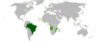
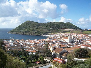
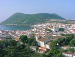
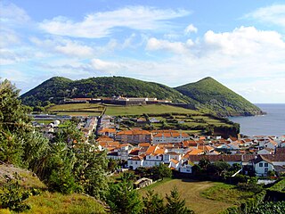
Angra do Heroísmo, generally known as Angra, is a municipality and city on the island of Terceira in the Portuguese autonomous region of the Azores. The population in 2011 was 35,402, in an area of 239.00 km². It forms the southern half of Terceira, with the north belonging to Praia da Vitória. Together with Ponta Delgada on São Miguel and Horta on Faial, Angra is one of the three regional capitals of the Azores. Each capital is responsible for one of the three branches of government. It is also the location of the Azorean bishop.

Lomba (Lajes das Flores) Civil Parish in Azores, Portugal

Lomba is a civil parish in the municipality of Lajes das Flores on the island of Flores in the Portuguese archipelago of the Azores. The population in 2011 was 206, in an area of 9.87 square kilometres (3.81 sq mi).

Altares Civil parish in Azores, Portugal

Altares is a freguesia in the municipality of Angra do Heroísmo on the Portuguese island of Terceira in the archipelago of the Azores. The population in 2011 was 901, in an area of 28.22 km².

Vila de São Sebastião Civil Parish in Azores, Portugal

Vila de São Sebastião, commonly shortened to São Sebastião, is a civil parish in the municipality of Angra do Heroísmo, on the island of Terceira in the Portuguese archipelago of the Azores. The population in 2011 was 2,096, in an area of 23.93 square kilometres (9.24 sq mi). It is in the southeastern part of the island of Terceira.

Ribeira Grande, Azores Municipality in Azores, Portugal

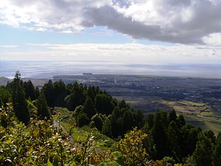
Ribeira Grande is a municipality in the northern part of the island of São Miguel in the Portuguese Azores. The population in 2011 was 32,112, in an area of 180.15 km². The municipal seat is located in the civil parish of Matriz, with a population of about 4000 inhabitants, part of the urbanized core of what is commonly referred to as the city of Ribeira Grande.

Almagreira (Vila do Porto) Civil Parish in Azores, Portugal

Almagreira is a civil parish in the municipality of Vila do Porto on the island of Santa Maria, in the Portuguese autonomous region of Azores. The population in 2011 was 599, in an area of 11.22 km². Bordering all other parishes of the island, it is located northwest of Vila do Porto.

Fortress of São João Baptista (Angra do Heroísmo)

The Fortress of São João Baptista, also known as the Fort of São Filipe or Fort of Monte Brasil is a historic fortress and defensive emplacement, located in the civil parish of Sé, municipality of Angra do Heroísmo in the Portuguese island of Terceira, archipelago of the Azores.

Castle of Moinhos

The Castle of Moinhos, officially known as the Castle of São Cristóvão, or Castle/Fort of São Luís is the name of the ruins of 16th-century fortification in city of Angra, on the Portuguese island of Terceira in the archipelago of the Azores. It is primarily known as the Castle of Moinhos, owing to the popular name given to the site for the number of mills that dotted the hilltop, on which the castle was erected.

Cais da Silveira

The Wharf of Silveira is situated in the Bay of Fanal, in the civil parish of São Pedro, in the municipality of Angra do Heroísmo, along the southern coast of Terceira, in the Portuguese archipelago of the Azores.

Fort of Negrito

The Fort of Negrito is a 16th century maritime fort situated in the civil parish of São Mateus da Calheta, in the municipality of Angra do Heroísmo on the island of Terceira, Azores, Portugal.

Fort of Má Ferramenta

The Fort of Má Ferramenta, near the port of the civil parish of São Mateus da Calheta, municipality of Angra do Heroísmo, along the southern coast of the Portuguese island of Terceira, in the archipelago of the Azores. Located in a dominant position over this coastal stretch of coast that sheltered anchored ships, it was a fortification used as a defence against attacks from pirates and corsairs, that frequented the waters of the mid-Atlantic.

Fort of Santo António do Monte Brasil

The Fort of Santo António, also known as the Redoubt of Santo António, is located on the peninsula of Monte Brasil, in the civil parish Sé, in the municipality of Angra do Heroísmo, along the southern coast of Terceira, Portuguese archipelago of the Azores. It is part of the complex of defensive structures of the Fort of São João Baptista, that crossed-fire with the Fort of São Sebastião in the defense of the Bay of Angra.

Duke of Terceira Garden

Duke of Terceira Garden is a manicured garden in the historical centre of Angra do Heroísmo, on the island of Terceira in the Portuguese archipelago of the Azores. One of the classic gardens emblematic of the Romantic period of Portuguese history, it is part of the municipal gardens of the city of Angra (located within the civil parish of Nossa Senhora da Conceição.

Angra do Heroísmo City Hall

The Angra do Heroísmo City Hall is a medieval structure constructed to house the municipal council/authority, situated in the civil parish of Sé, municipality of Angra do Heroísmo, on the Portuguese archipelago of the Azores.

Fort of Santa Cruz (Horta)

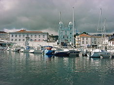
Fort of Santa Cruz, is a 16th-century fortification located in the civil parish of Angústias, municipality of Horta, on the island of Faial in the Portuguese Azores. Occasionally referred to as the Castelo de Santa Cruz by locals, it is situated in the historic centre of the city, on the edge of Horta Bay. It was constructed to work in conjunction with the Fort of Bom Jesus at the mouth of the Ribeira da Conceição and Fort of Greta along the coast of the extinct spatter cone Monte da Guia, to defend the entrance to the harbour and southern access to the Bay.

Fort of the Church of São Mateus da Calheta

The Fort of the Church São Mateus da Calheta, also referred to as the Forte da Igreja, are the coastal ruins of a 16th-century fort situated in the civil parishof São Mateus da Calheta, municipality of Angra do Heroísmo, on the Portuguese island of Terceira, in the archipelago of the Azores. It was destroyed, along with the church, in 1893 during a cyclone; while the church was eventually reconstructed some years later, the fort was abandoned and left to ruin.

Fort of the Espírito Santo

The Fort of the Espírito Santo is the remains of a 16th-century fortification located on the extreme northern edge of the Bay of Praia da Vitória, in the Portuguese civil parish of Santa Cruz, municipality of Praia da Vitória, on the island of Terceira, in the Azores.

Fort of São João Baptista of Praia Formosa

The Fort of São João Baptista is the ruins of a 16th-century maritime fort situated on the western edge of Praia Formoso, in the civil parish of Almagreira, municipality of Vila do Porto, on the Portuguese island of Santa Maria.

References

Notes

  1. SREAS pamphlet (1983)

Sources