The Azores, officially the Autonomous Region of the Azores, is one of the two autonomous regions of Portugal. It is an archipelago composed of nine volcanic islands in the Macaronesia region of the North Atlantic Ocean, about 1,400 km (870 mi) west of Lisbon, about 1,500 km (930 mi) northwest of Morocco, and about 1,930 km (1,200 mi) southeast of Newfoundland, Canada.

Terceira is a volcanic island in the Azores archipelago, about a third of the way across the North Atlantic Ocean at a similar latitude to Portugal's capital Lisbon, and the island group is owned by Portugal. It is one of the larger islands of the archipelago, with a population of 53,311 inhabitants in an area of approximately 396.75 km².

Postage stamps and postal history of the Azores surveys the postal history of the Portuguese archipelago, situated in the north Atlantic.

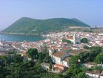
Angra do Heroísmo, or simply Angra, is a city and municipality on Terceira Island, Portugal, and one of the three capital cities of the Azores. Founded in 1478, Angra was historically the most important city in the Azores, as seat of the Bishop of the Azores, government entities, and having previously served as the capital city of Portugal during the Liberal Wars. The population in 2011 was 35,402, in an area of 239.00 km2. It was classified as a World Heritage site by UNESCO in 1983.

The Bay of Pontas is a bay, in the civil parish of Feteira, municipality of Angra do Heroísmo, in the Portuguese archipelago of the Azores. The waterbody is situated along the southern coast of the island of Terceira across from the Cabras Islet.
The Castle of Moinhos, officially known as the Castle of São Cristóvão, or Castle/Fort of São Luís is the name of the ruins of 16th-century fortification in city of Angra, on the Portuguese island of Terceira in the archipelago of the Azores. It is primarily known as the Castle of Moinhos, owing to the popular name given to the site for the number of mills that dotted the hilltop, on which the castle was erected.

The Lagoa do Negro is an ephemeral lake and humid zone located in the civil parish of Biscoitos, municipality of Praia da Vitória, on the island of Terceira, Portuguese archipelago of the Azores.
The Fort of Má Ferramenta, near the port of the civil parish of São Mateus da Calheta, municipality of Angra do Heroísmo, along the southern coast of the Portuguese island of Terceira, in the archipelago of the Azores. Located in a dominant position over this coastal stretch of coast that sheltered anchored ships, it was a fortification used as a defence against attacks from pirates and corsairs, that frequented the waters of the mid-Atlantic.

Fort of São João, also known as Fort of Biscoitinho, is a medieval fort, in the civil parish of São Mateus da Calheta, in the municipality of Angra do Heroísmo, on the Portuguese archipelago of the Azores.

The Fort of Cinco Ribeiras, also known as the Fort of Nossa Senhora do Pilar or Fort of São Bartolomeu, ruins of a 16th-century fortification located in the municipality of Angra do Heroísmo, along the southeast coast of Terceira, Portuguese archipelago of the Azores.
The Fort of the Açougue, ruins of a 16th-century fortification located in the municipality of Angra do Heroísmo, along the southern coast of Terceira, Portuguese archipelago of the Azores.
The Fort of the Caninas, is a medieval fort situated in the Portugueses civil parish of Porto Judeu, municipality of Angra do Heroísmo, in the archipelago Azores.
Fort of the Cavalas is a fort situated in the civil parish of São Sebastião in the municipality of Angra do Heroísmo, in the Portuguese archipelago of the Azores.
The Dois Paus redoubt is a redoubt fortification situated on the peninsula of Monte Brasil, in the civil parish of Sé, in the municipality of Angra do Heroísmo, in the Portuguese archipelago of the Azores. It was part of the fortified defenses of the Fortress of São João Baptista.
Miradouro da Ponta do Queimado is a monument in the Azores. It is located in Angra do Heroísmo, on the island of Terceira.
The Fort of the Church São Mateus da Calheta, also referred to as the Forte da Igreja, are the coastal ruins of a 16th-century fort situated in the civil parish of São Mateus da Calheta, municipality of Angra do Heroísmo, on the Portuguese island of Terceira, in the archipelago of the Azores. It was destroyed, along with the church, in 1893 during a cyclone; while the church was eventually reconstructed some years later, the fort was abandoned and left to ruin.
The Captaincy-General of the Azores (1766—1832) was a politico-administrative structure of governance imposed in the Azores on 2 August 1766, with its seat in Angra. It remained the de facto system of governance for 65 years, until it was abolished on 4 June 1832 by D. Peter IV, but by 1828 its de jure status had made it nonoperational, owing to the revolutionary movements that lead to the Liberal Wars. The creation of the Captaincy-General was part of the Pombaline reforms to the Portuguese administration, during the reign of Joseph I, under the initiatives of Sebastião José de Carvalho e Melo, 1st Marquis of Pombal, then prime minister. A Captaincy-General operated from the Palace of the Captains-General, under the direction of the titular Captain-General, who operated as the Governor of the Azores, with additional jurisdiction on every island of the Azorean archipelago. The Captaincy-General was succeeded by the Province of the Azores, an ephemeral administrative structure that was collapse in the immediate years.
The District of Angra do Heroísmo, was a district of the Ilhas Adjacentes, consisting of the dependent central islands of the Azores. The district of Angra, not to be confused with the modern municipality of Angra do Heroísmo, existed until 1976 when it was abolished in the favor of the autonomy charter of the 1976 Portuguese Constitution.
The Fort of Greta is a fort along the promontory of Santa Catarina, on the western edge of the Bay of Mós, in the civil parish of Vila de São Sebastião, in the municipality of Angra do Heroísmo, on the Portuguese archipelago of the Azores.