Geography
The valley is the basin of Callaghan Creek, at the head of which is Callaghan Lake and associated provincial park. Midway down Callaghan Creek is the confluence of Madeley Creek, just above which on that creek is Alexander Falls, which lies just at a bridge on the road to Callaghan Lake.
Callaghan Lake Provincial Park is a provincial park in British Columbia, Canada, located in the upper Callaghan Valley to the west of the resort town of Whistler. The dormant volcano Mount Callaghan overlooks the lake on its north side, while just to the south of the park is the sliding events facility for the 2010 Olympics. Callaghan Lake was to be the site of the base village for a proposed ski resort, Powder Mountain Resort, but the project never went through due to alleged interference by William Vander Zalm and others in the then-Social Credit government.

Alexander Falls is a waterfall on Madeley Creek, a tributary of Callaghan Creek in the Callaghan Valley area of the Sea to Sky Country of southwestern British Columbia, Canada. The falls are located just below a bridge on the access road to Callaghan Lake Provincial Park, at the head of the valley, which lies to the west of the resort town of Whistler.
On its western perimeter is the Powder Mountain Icefield, and the potentially active [1] [2] volcano Mount Cayley, which lies at the valley's southwestern extremity. Mount Callaghan, at the head of the valley, is a dormant volcano because its last eruption was not as recent as Mount Cayley's, nor does it display hot spring or seismic activity. The valley's eastern wall is the small range formed by Mount Sproatt and Rainbow Mountain, which lies in the angle of the Cheakamus River and Callaghan Creek (which in the past has also been known as the West Fork of the Cheakamus) and east of which is the Resort Municipality of Whistler. The valley's mouth and road access is at McGuire's on BC Highway 99, 14 kilometres south of downtown Whistler, in British Columbia. The location is also known as Northair, and the road as the Northair Mine Road, after a mine located a few miles north of the junction, which is marked by a quarry pit columnar basalt lava rock on the opposite side of the highway, and which are the northern end of a small lava plateau between the highway and river south to and including Brandywine Falls. Volcanoes in the Callaghan Valley were erupted between 25,000 and 11,000 years ago whose age is extremely young in the geologic record. [3]

The Powder Mountain Icefield, also called the Powder Mountain Icecap and the Cayley Icefield, is a glacial field in the Pacific Ranges of southwestern British Columbia, Canada, about 20 kilometres (12 mi) west of Whistler and about 90 kilometres (56 mi) north of Vancouver. On the west side of the icefield is the valley of the Squamish River, while on its east is the Callaghan Valley, which is the setting for the Nordic facilities for the 2010 Winter Olympics.
Mount Cayley is a mountain and highest point of the Mount Cayley massif between the Cheakamus and Squamish rivers in British Columbia, Canada. It has an elevation of 2,385 m (7,825 ft).

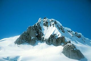
Mount Callaghan is a volcanic peak located east of the headwaters of the Squamish River, just northeast of the Powder Mountain Icefield and just south of the Pemberton Icefield in the Sea to Sky Country of southwestern British Columbia, Canada, about 20 km directly west of the Resort Municipality of Whistler. A crack was observed across Callaghan's summit in the spring of 1999. In 2000, a section of the summit collapsed. Callaghan Lake lies below the south face of the mountain.

Mount Garibaldi is a potentially active stratovolcano in the Sea to Sky Country of British Columbia, 80 km (50 mi) north of Vancouver, British Columbia, Canada. Located in the southernmost Coast Mountains, it is one of the most recognized peaks in the South Coast region, as well as British Columbia's best known volcano. It lies within the Garibaldi Ranges of the Pacific Ranges.

The Garibaldi Volcanic Belt is a northwest-southeast trending volcanic chain in the Pacific Ranges of the Coast Mountains that extends from Watts Point in the south to the Ha-Iltzuk Icefield in the north. This chain of volcanoes is located in southwestern British Columbia, Canada. It forms the northernmost segment of the Cascade Volcanic Arc, which includes Mount St. Helens and Mount Baker. Most volcanoes of the Garibaldi chain are dormant stratovolcanoes and subglacial volcanoes that have been eroded by glacial ice. Less common volcanic landforms include cinder cones, volcanic plugs, lava domes and calderas. These diverse formations were created by different styles of volcanic activity, including Peléan and Plinian eruptions.

Garibaldi Provincial Park, also called Garibaldi Park, is a wilderness park located in British Columbia, Canada, about 70 kilometres (43.5 mi) north of Vancouver. The park is located to the east of the Sea to Sky Highway between Squamish and Whistler and covers an area of over 1,950 square kilometres. Garibaldi was designated as a provincial park in 1927, and originally included what was later split off in 1967 as Golden Ears Provincial Park, which juts southward between the basins of Pitt Lake and the Stave River into the Municipality of Maple Ridge.

The Cheakamus River is a tributary of the Squamish River, beginning on the west slopes of Outlier Peak in Garibaldi Provincial Park upstream from Cheakamus Lake on the southeastern outskirts of the resort area of Whistler. The river flows into Cheakamus Lake before exiting it and flowing northwest until it turns south and enters Daisy Lake. Between the outlet of Daisy Lake and its mouth, much of its length is spent going through Cheakamus Canyon, where the river flows through swift rapids and even one good sized waterfall. The river flows south from the lake and through the canyon before joining the Squamish River at Cheekye, a few miles north of the town of Squamish. The river's name is an anglicization of the name of Chiyakmesh, a village of the Squamish people and a reserve of the Squamish Nation.

The Black Tusk is a stratovolcano and a pinnacle of volcanic rock in Garibaldi Provincial Park of British Columbia, Canada. At 2,319 m (7,608 ft) above sea level, the upper spire is visible from a great distance in all directions. It is particularly noticeable from the Sea-to-Sky Highway just south of Whistler, British Columbia. Distinctive and immediately identifiable, The Black Tusk is among the best known mountains in the Garibaldi Ranges of the Coast Mountains. The volcano is part of the Garibaldi Volcanic Belt which is a segment of the Canadian Cascade Arc, but it is not within the geographic boundary of the Cascade Range.

Brandywine Falls Provincial Park is a provincial park in British Columbia, Canada, located adjacent to BC Highway 99 between Garibaldi and Whistler, British Columbia.
It is managed by Sea to Sky Parks for BC Parks.

Mount Price is a small stratovolcano in the Garibaldi Ranges of the Pacific Ranges in southwestern British Columbia, Canada. It is located 10 km (6.2 mi) southeast of the abandoned settlement of Garibaldi above the eastern flank of the Cheakamus River valley. With a summit elevation of 2,052 m (6,732 ft) and a topographic prominence of 402 m (1,319 ft), it rises above the surrounding landscape on the western shore of Garibaldi Lake. A large provincial park surrounds Mount Price and other volcanoes in its vicinity.
The Sea-to-Sky Corridor, often referred to as the Corridor, or the Sea to Sky Country, is a region in British Columbia spreading from Horseshoe Bay through Whistler to the Pemberton Valley and sometimes beyond to include Birken and D'Arcy. From Whistler on up, the region overlaps with the older and more historic Lillooet Country, of which Squamish, at the region's centre, was once the southward extension in the days when it was the rail-port terminus from the Interior, via Lillooet, and accessible from the Lower Mainland only by sea. Most of the region is in the Squamish-Lillooet Regional District, although south of Brittania Beach a small part of the region is in the Greater Vancouver Regional District.

Garibaldi Lake is a turquoise-coloured alpine lake in British Columbia, Canada, located 37 km (23 mi) north of Squamish and 19 km (12 mi) south of Whistler. The lake lies within Garibaldi Provincial Park, which features mountains, glaciers, trails, forests, flowers, meadows, waterfalls. The park is a wildlife protected area.

The Barrier is a lava dam retaining the Garibaldi Lake system in southwestern British Columbia, Canada. It is over 300 m (980 ft) thick and about 2.4 km (1.5 mi) long where it impounds the lake.
Daisy Lake, also referred to as Daisy Lake Reservoir, is a reservoir on the Cheakamus River in the Sea to Sky Corridor of southwestern British Columbia, Canada, just south of the Resort Municipality of Whistler and immediately north of the abandoned townsite of Garibaldi.
Brandywine Creek, also formerly known as the Long John River after a local prospector and trapper, is a tributary of the Cheakamus River in the Pacific Ranges of the Coast Mountains in British Columbia, Canada, entering that stream via Daisy Lake, just below Brandywine Falls. The creek is about 14 km in length and originates on the south slope of Brandywine Mountain in Brandywine Meadows, at the southern end of the Powder Mountain Icefield and is the next basin immediately southwest of that of the Callaghan Valley, the site of the Nordic events facility for the 2010 Olympics. The creek's valley has been partially logged. An unnamed hot spring lies in its upper reaches, near Mount Fee.
Powder Mountain, 2,347 m (7,700 ft), is a volcanic summit in the Powder Mountain Icefield in the Pacific Ranges of the Coast Mountains in southwestern British Columbia, Canada.
The Fitzsimmons Range is a small mountain range on the northwestern edge of the Garibaldi Ranges in southwestern British Columbia, Canada, located between the valleys of Cheakamus Lake (SW) and Fitzsimmons Creek (NE). Its most famous summit is Whistler Mountain, which overlooks the resort town of Whistler and is one of the two mountains forming the Whistler Blackcomb ski resort. Most of the range is within Garibaldi Provincial Park, while its northeastern extremity is part of the resort municipality, and of the lands associated with the ski resort operation. Other summits in the range include Oboe Summit, Piccolo Summit and Flute Summit, which are hillocks along the ridge running southeast from Whistler Mountain and were named in association with the renaming of Whistler. Beyond them is Singing Pass and Mount Fitzsimmons 2603 m (8540 ft) which is at the opposite end of the range from Whistler Mountain and the location of Fitzsimmons Glacier, which is the source of Fitzsimmons Creek.

The Mount Cayley volcanic field is a remote volcanic zone on the South Coast of British Columbia, Canada, stretching 31 km (19 mi) from the Pemberton Icefield to the Squamish River. It forms a segment of the Garibaldi Volcanic Belt, the Canadian portion of the Cascade Volcanic Arc, which extends from Northern California to southwestern British Columbia. Most of the Cayley volcanoes were formed during periods of volcanism under sheets of glacial ice throughout the last glacial period. These subglacial eruptions formed steep, flat-topped volcanoes and subglacial lava domes, most of which have been entirely exposed by deglaciation. However, at least two volcanoes predate the last glacial period and both are highly eroded. The field gets its name from Mount Cayley, the largest and most persistent volcano, located at the southern end of the Powder Mountain Icefield. This icefield covers much of the central portion of the volcanic field and is one of the several glacial fields in the Pacific Ranges of the Coast Mountains.

The Mount Cayley massif is a group of mountains in the Pacific Ranges of southwestern British Columbia, Canada. Located 45 km (28 mi) north of Squamish and 24 km (15 mi) west of Whistler, the massif resides on the edge of the Powder Mountain Icefield. It consists of an eroded but potentially active stratovolcano that towers over the Cheakamus and Squamish river valleys. All major summits have elevations greater than 2,000 m (6,600 ft), Mount Cayley being the highest at 2,385 m (7,825 ft). The surrounding area has been inhabited by indigenous peoples for more than 7,000 years while geothermal exploration has taken place there for the last four decades.


