Callanafersy

Last updated
Callanafersy
Native name
Irish: Caladh na Feirse
Ireland adm location map.svg
Red pog.svg
Location of Callanafersy in Ireland
Type stone ringfort
Location Callanafersy West, Killorglin,
County Kerry, Ireland
Coordinates 52°08′16″N9°46′41″W / 52.137695°N 9.778073°W / 52.137695; -9.778073 Coordinates: 52°08′16″N9°46′41″W / 52.137695°N 9.778073°W / 52.137695; -9.778073
Elevation 14 m (46 ft)
Built c. 7th century AD
Architectural style(s) Gaelic Ireland
Owner State [1]
Official name: Callanafersy Ringfort [2] [3]
Reference no. 238

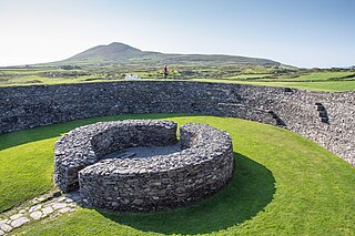
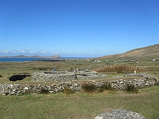
Callanafersy is a stone ringfort (cashel) and National Monument located in County Kerry, Ireland. [4]

Ringfort Circular fortified settlements found in Northern Europe

Ringforts, ring forts or ring fortresses are circular fortified settlements that were mostly built during the Bronze age up to about the year 1000. They are found in Northern Europe, especially in Ireland. There are also many in South Wales and in Cornwall, where they are called rounds. Ringforts come in many sizes and may be made of stone or earth. Earthen ringforts would have been marked by a circular rampart, often with a stakewall. Both stone and earthen ringforts would generally have had at least one building inside.

County Kerry County in the Republic of Ireland

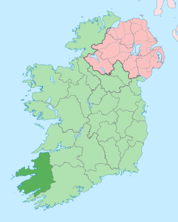
County Kerry is a county in Ireland. It is located in the South-West Region and forms part of the province of Munster. It is named after the Ciarraige who lived in part of the present county. Kerry County Council is the local authority for the county and Tralee serves as the county town. The population of the county was 147,707 at the 2016 census.

Republic of Ireland Ireland, a country in north-western Europe, occupying 5/6 of the island of Ireland; succeeded the Irish Free State (1937)

Ireland, also known as the Republic of Ireland, is a country in north-western Europe occupying 26 of 32 counties of the island of Ireland. The capital and largest city is Dublin, which is located on the eastern part of the island, and whose metropolitan area is home to around a third of the country's over 4.8 million inhabitants. The sovereign state shares its only land border with Northern Ireland, a part of the United Kingdom. It is otherwise surrounded by the Atlantic Ocean, with the Celtic Sea to the south, Saint George's Channel to the south-east, and the Irish Sea to the east. It is a unitary, parliamentary republic. The legislature, the Oireachtas, consists of a lower house, Dáil Éireann, an upper house, Seanad Éireann, and an elected President who serves as the largely ceremonial head of state, but with some important powers and duties. The head of government is the Taoiseach, who is elected by the Dáil and appointed by the President; the Taoiseach in turn appoints other government ministers.

Contents

Location

Callanafersy is 3.3 km (2.1 mi) north of Killorglin.

Killorglin Town in Munster, Ireland

Killorglin is a town in County Kerry, South West of Rep. of Ireland. Killorglin is located on the Ring of Kerry and The Wild Atlantic Way.

History

The cashel was built around the 7th century AD as a defended farmstead.

Description

This is a circular stone ringfort (caiseal).

Related Research Articles

Mullyash Kerbed Cairn Barrow in Ireland

Mullyash Kerbed Cairn is a kerb cairn and National Monument located in County Monaghan, Ireland.

Cashelore stone ringfort in County Sligo, Ireland

Cashelore, also called Cashel Bir or Bawnboy, is a stone ringfort (cashel) and National Monument located in County Sligo, Ireland.

Drummin fort

Drummin fort is a ringfort and National Monument located in County Roscommon, Ireland.

Barnacahoge Cashel

Barnacahoge Cashel, is a stone ringfort (cashel) and National Monument located in County Mayo, Ireland.

Rathsoony

Rathsoony is a ringfort and National Monument located in County Galway, Ireland.

Cashlaungar

Cashlaungar, also Cashlaungarr, Cashlaun Gar or Cashlán Gar, is a stone ringfort (cashel) and National Monument located in The Burren, a region in County Clare, Ireland.

Cush Earthworks

The Cush Earthworks are a series of earthworks, and a National Monument, located in County Limerick, Ireland.

Cloghanecarhan

Cloghanecarhan is a ringfort and ogham stone forming a National Monument located in County Kerry, Ireland.

Ratass Church Church in County Kerry, Ireland

Ratass Church is a medieval church with ogham stone forming a National Monument in Tralee, Ireland.

Loher Cashel

Loher Cashel is a stone ringfort (cashel) and National Monument located on the Iveragh Peninsula, Ireland.

Annagh Church Church in County Kerry, Ireland

Annagh Church is a medieval church and National Monument in County Kerry, Ireland.

Leacanabuaile

Leacanabuaile is a stone ringfort (cashel) and National Monument located in County Kerry, Ireland.

Cahergall

Cahergall is a stone ringfort (cashel) and National Monument located in County Kerry, Ireland.

Emlagh East Cashel

Emlagh East Cashel is a stone ringfort (cashel) and National Monument located in County Kerry, Ireland.

Caherdorgan North

Caherdorgan North is a National Monument located in County Kerry, Ireland.

Aughrim Ringforts

Aughrim Ringforts are a pair of ringforts forming a National Monument located in County Galway, Ireland.

Kiltiernan Church Church in County Galway, Ireland

Kiltiernan Church is a medieval church and National Monument in County Galway, Ireland.

Ballynavenooragh

Ballynavenooragh is a stone fort and National Monument located in County Kerry, Ireland.

Glin North

Glin North is the location of a National Monument in County Kerry, Ireland.

Ballinknockane Site of Irish national monument

Ballinknockane is the location of a National Monument in County Kerry, Ireland.

References