
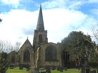
Wirksworth is a market, and former quarry town in the Derbyshire Dales district of Derbyshire, England. Its population of 4,904 in the 2021 census was estimated at 5,220 in 2023. Wirksworth contains the source of the River Ecclesbourne. The town was granted a market charter by Edward I in 1306 and still holds a market on Tuesdays in the Memorial Gardens. The parish church of St Mary's is thought to date from 653. The town developed as a centre for lead mining and stone quarrying. Many lead mines were owned by the Gell family of nearby Hopton Hall.
Duffield is a village in the Amber Valley district of Derbyshire, 5 miles (8.0 km) north of Derby. It is centred on the western bank of the River Derwent at the mouth of the River Ecclesbourne. It is within the Derwent Valley Mills World Heritage Area and the southern foothills of the Pennines.

This article details some of the history of lead mining in Derbyshire, England.

The history of Derbyshire can be traced back to human settlement since the last Ice Age, over 10,000 years ago. The county of Derbyshire in England dates back to the 11th century.
Duffield Frith was, in medieval times, an area of Derbyshire in England, part of that bestowed upon Henry de Ferrers by King William, controlled from his seat at Duffield Castle. From 1266 it became part of the Duchy of Lancaster and from 1285 it was a Royal Forest with its own Forest Courts.

Dethick, Lea and Holloway is a civil parish, in the Amber Valley borough of the English county of Derbyshire. The population of the civil parish taken at the 2011 census was 1,027.

Ashleyhay is a village and civil parish in the Amber Valley district of Derbyshire, England, about five miles north-west of Belper. It is also situated one and three-quarters of a mile south of Wirksworth and eleven miles north of Derby city centre. According to the 2001 census it had a population of 105, increasing to 118 at the 2011 Census.

Carsington is a village in the middle of the Derbyshire Dales, England; it adjoins the hamlet of Hopton, and is close to the historic town of Wirksworth and village of Brassington.
Windley is a small village and civil parish in Derbyshire, England, around 6 miles (10 km) north of Derby, adjacent to the B5023 Duffield to Wirksworth road. The civil parish population as taken at the 2011 Census was 148.

Shottle is a village approximately 3 miles (4.8 km) south of the market town of Wirksworth in Derbyshire. The population of the civil parish at the 2011 Census was 266.

The Forest of High Peak was, in medieval times, a moorland forest covering most of the north west of Derbyshire, England, extending as far south as Tideswell and Buxton. From the time of the Norman Conquest it was established as a royal hunting reserve, administered by William Peverel, a follower of William I, who was based at Peveril Castle. The Royal Forest of Peak was bounded by the River Goyt to the west, the River Wye to the south, the River Derwent to the east and the River Etherow to the north. In 1305 it covered about 100 square miles.
Ravensdale Park is a civil parish in the Derbyshire Dales district of Derbyshire roughly 3 miles (5 km) WSW of Belper, Derbyshire, England, midway between Turnditch and Brailsford. The population of the civil parish as taken at the 2011 Census was less than 100. Details are included in the South Derbyshire civil parish of Dalbury Lees.

Parwich is a village and parish in the Derbyshire Dales, 7 miles north of Ashbourne. In the 2011 census the population of the civil parish was 472.

Melbourne Castle was a medieval castle in Melbourne, Derbyshire. It was built on the site of an earlier royal manor house that had provided accommodation for noblemen hunting in a nearby royal park in the reign of King John. Construction of the castle was started in 1311 by Thomas, 2nd Earl of Lancaster, and continued until 1322, shortly before his execution, but the work was never fully completed.
The honour of Pontefract, also known as the feudal barony of Pontefract, was an English feudal barony. Its origins lie in the grant of a large, compact set of landholdings in Yorkshire, made between the Norman conquest of England in 1066 and the completion of the Domesday Survey in 1086. An expansive set of landholdings spanning sixty parishes and six wapentakes in Yorkshire, the honour was created primarily to serve a strategic, defensive function in a potentially hostile frontier zone. The first lord was Ilbert de Lacy, who built a castle at Pontefract which became the caput of the honour. Alongside the Yorkshire holdings, a smaller number of dispersed possessions elsewhere in England belonged to the honour.

Sir Godfrey de Foljambe was a prominent landowner and politician in fourteenth-century England, who was a Baron of the Exchequer and chief steward of the duchy of Lancaster. He went on to have a successful career as an Irish judge, including three years as Lord Chief Justice of Ireland. He was initially a servant of Philippa of Hainault before becoming a prominent member of the affinity of her son, John of Gaunt, Duke of Lancaster. His tomb can still be seen at All Saints Church, Bakewell.
Sir John Cockayne was an English soldier, politician and landowner whose wealth made him a major force in the affairs of Derbyshire under the House of Lancaster. After numerous acts of criminality in concert with other Midlands landowners, he became a member of the Lancastrian affinity centred on John of Gaunt and a supporter of Henry IV. He fought in two campaigns of the Hundred Years War but his violence and lawlessness continued and he was decidedly out of favour during the reign of Henry V. With power less concentrated in the early years of Henry VI, he was able to serve three terms as High Sheriff of Nottinghamshire, Derbyshire and the Royal Forests and to wield considerable power and influence. He represented Derbyshire no less than nine times and Warwickshire twice in the House of Commons of England.
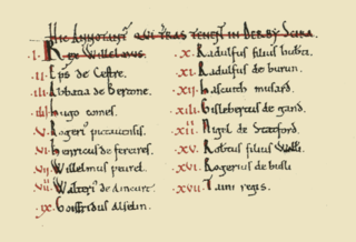
The Domesday Book of 1086 AD lists King William the Conqueror's tenants-in-chief in Derbyscire (Derbyshire), following the Norman Conquest of England:
The Hundreds of Derbyshire were the geographic divisions of the historic county of Derbyshire for administrative, military and judicial purposes. They were established in Derbyshire some time before the Norman conquest. In the Domesday Survey of 1086 AD the hundreds were called wapentakes. By 1273 the county was divided into 8 hundreds with some later combined, becoming 6 hundreds over the following centuries. The Local Government Act 1894 replaced hundreds with districts. Derbyshire is now divided into 8 administrative boroughs within the Derbyshire County Council area.

The Moot Hall is a judicial building in Chapel Lane in Wirksworth, Derbyshire, England. The building, which is used as the meeting place of the barmote court, a body formed to regulate the local lead mining industry, is a Grade II listed building.
