Cambria is a populated place in Harford County, Maryland, northwest of Whiteford. [1]
Many slate quarries were in operation to the southeast of Cambria in the 1800s. The region was known as the Peach Bottom Slate area. [2]
 Whiteford Quarry, Cambria, c. 1898
 York and Peachbottom Quarry, Cambria, c. 1898
 York and Peachbottom Quarry, Cambria, c. 1898
 Proctor Brothers' Quarry, Cambria, c. 1898
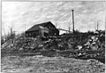
 Peachbottom-Excelsior-Peerless Quarry, Cambria, c. 1898


