Palencia is a province of northern Spain, in the northern part of the autonomous community of Castile and León in the northwest of the Iberian Peninsula. It is bordered by the provinces of León, Cantabria, Burgos, and Valladolid.

The Province of Burgos is a province of northern Spain, in the northeastern part of the autonomous community of Castile and León. It is bordered by the provinces of Palencia, Cantabria, Vizcaya, Álava, La Rioja, Soria, Segovia, and Valladolid. Its capital is the city of Burgos.
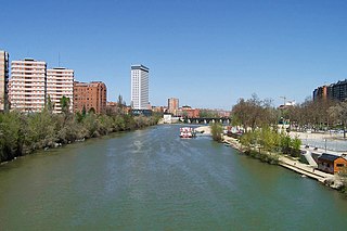
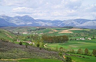
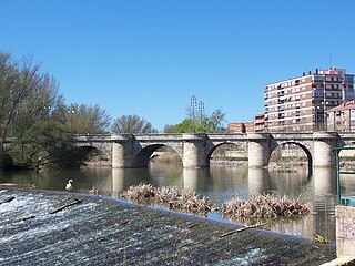
The Pisuerga is a river in northern Spain, the Duero's second largest tributary. It rises in the Cantabrian Mountains in the province of Palencia, autonomous region of Castile and León. Its traditional source is called Fuente Cobre, but it has been discovered that the real source is a glacier higher in the mountains. The river flows south into the Douro river shortly after passing through the city of Valladolid. Its length is approximately 270 kilometres (170 mi).
The Carrión is a river in northern Spain. Its source is in the mountain range called Fuentes Carrionas, and it is a tributary of the river Pisuerga. The entire course of the river is within the province of Palencia.
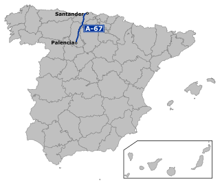
The Autovía A-67 is a highway in north west Spain. It connects the Cantabrian Atlantic Coast at Santander to Palencia. It follows the route of the N-611.

Melgar de Fernamental is a municipality and town lying by the Pisuerga river, located in the province of Burgos, Castile and León, Spain. According to the 2008 census (INE), the municipality has a population of 1,898 inhabitants.

Berzosilla is a municipality located in the province of Palencia, Castile and León, Spain. According to the 2004 census (INE), the municipality has a population of 63 inhabitants.

Cervera de Pisuerga is a municipality located in the province of Palencia, Castile and León, Spain. According to the 2004 census (INE), the municipality had a population of 2,679 inhabitants.

Herrera de Pisuerga is a municipality located in the province of Palencia, Castile and León, Spain. According to the 2004 census (INE), the municipality has a population of 2,457 inhabitants.

Magaz de Pisuerga is a municipality located in the province of Palencia, Castile and León, Spain. According to the 2004 census (INE), the municipality has a population of 755 inhabitants.

Salinas de Pisuerga is a municipality located in the province of Palencia, Castile and León, Spain. According to the 2004 census (INE), the municipality has a population of 337 inhabitants.
Valbuena de Pisuerga is a municipality located in the province of Palencia, Castile and León, Spain. According to the 2004 census (INE), the municipality has a population of 68 inhabitants.

The Turmodigi were a pre-Roman ancient people, later mixed with the Celts people of northern Spain who occupied the area within the Arlanzón and Arlanza river valleys in the 2nd Iron Age.

Páramos, also known as "Sedano y Las Loras", is a comarca located northwest of the province of Burgos in the autonomous community of Castile and León. It is bounded on the north-east by the Merindades, north-west by Cantabria, west by the Province of Palencia, and in the south by the Alfoz de Burgos and Odra-Pisuerga comarcas.
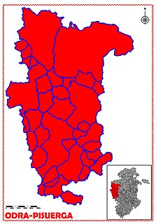
Odra-Pisuerga is a comarca located in the west of the province of Burgos, in the autonomous community of Castile and León, Spain. It is bounded by the west and south-west by the province of Palencia, south-east by the Arlanza comarca, west by the Alfoz de Burgos and north by the Páramos comarca.

Comarca del Arlanza is a comarca located south-east of the province of Burgos in the autonomous community of Castile and León. It is bounded on the north by the Odra-Pisuerga and the Alfoz de Burgos, south by the Ribera del Duero, on the east by the province of Palencia and west by the Sierra de la Demanda.
The Battle of Vellica was a battle of the Cantabrian Wars fought in the year 25 BC by the emperor Augustus and his Roman legions against the Cantabri forces who resided in the area. The most generally accepted location for the battle is the area around Monte Cildá, Olleros de Pisuerga, Palencia.

El Cerrato is a natural comarca in Spain comprising locations in the provinces of Palencia, Burgos and Valladolid, although the largest part lies within Palencia. With an area of 1,534 km², almost 25,000 inhabitants and an average elevation of 783 meters above sea level, the region contains 37 villages and the city of Dueñas. Its capitals throughout history have been Castroverde de Cerrato, Palenzuela and, from the late fifteenth century, Baltanás, the largest municipality.
Celada de Roblecedo is a town in the province of Palencia, in Castille and León, northern Spain.

Peña Labra is a 2,018 metres (6,621 ft) high mountain located in the Sierra de Híjar range, a part of the Cantabrian Mountains System,. It is located on the boundary between the Province of Palencia and the Autonomous Community of Cantabria.
