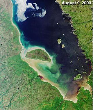
James Bay is a large body of water located on the southern end of Hudson Bay in Canada. It borders the provinces of Quebec and Ontario, and is politically part of Nunavut. Its largest island is Akimiski Island.

Algonquin Provincial Park is an Ontario provincial park located between Georgian Bay and the Ottawa River, mostly within the Unorganized South Part of Nipissing District. Established in 1893, it is the oldest provincial park in Canada. Additions since its creation have increased the park to its current size of about 7,653 km2 (2,955 sq mi). The park is contiguous with several smaller, administratively separate provincial parks that protect important rivers in the area, resulting in a larger total protected area.

The Mattawa River is a river in central Ontario, Canada. It flows east from Trout Lake east of North Bay and enters the Ottawa River at the town of Mattawa. Counting from the head of Trout Lake, it is 76 kilometres (47 mi) long. The river's name comes from the Algonquin word for "meeting of waterways".

The Missinaibi River is a river in northern Ontario, Canada, which flows northeast from Missinaibi Lake, north of Chapleau, and empties into the Moose River, which drains into James Bay. This river is 755 kilometres (469 mi) in length. It is one of the longest free-flowing and undeveloped rivers in Ontario.

Canoe camping, also known as touring, tripping or expedition canoeing, is a combination of canoeing and camping. Canoe campers typically carry enough supplies with them to travel and camp for several days via a canoe.
Lake Temagami, formerly spelled as Lake Timagami, is a lake in Nipissing District in northeastern Ontario, Canada, situated approximately 80 km north of North Bay. The lake's name comes from dimii-agamiing "tih-MEE-uh-guh-MEENG", which means "it is deep water by the shore" in the Ojibwa language.
The Keewaydin Foundation is an organization that manages a number of summer canoe camps based in Ontario and Vermont, as well as an environmental educational center. In Algonquin, Keewaydin is the Northwest wind, considered to be the bearer of good fortune and fair weather.
Camp Northway, formerly Northway Lodge, is the oldest summer camp for girls in Canada, and overall Canada's fourth oldest summer camp. It was founded in 1906 and relocated to Algonquin Park, Ontario, in 1908. The camp has maintained a distinctive ethos of simple camping, crafts, and drama. Much of this is the continuing legacy of the Camp's charismatic founder, Miss Fannie L. Case.
South River is a village on Highway 124 near Algonquin Park in the Almaguin Highlands region of Parry Sound District of Ontario, Canada. It is about halfway between North Bay and Huntsville or a 3-hour drive (300 km) north from Toronto. South River has access to the Algonquin Park for canoeists at Kawawaymog. South River is home of Mikisew Provincial Park on the shores of Eagle Lake.
The Obabika River Provincial Park is a provincial park in Ontario, Canada, straddling across the boundaries of the Sudbury, Nipissing, and Timiskaming Districts. While it is named after and includes the Obabika River, the bulk of the park extends north of Obabika Lake to the eastern boundary of Lady Evelyn-Smoothwater Provincial Park.

Lady Evelyn-Smoothwater Provincial Park is a remote wilderness park in northeastern Ontario, Canada, north of Lake Temagami. This operating park, requiring permits for all visitors, encompasses "rugged topography, clear lakes, stunning waterfalls, and rushing rivers".
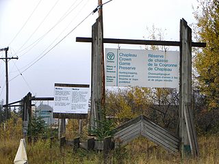
The Chapleau Crown Game Preserve is a fur bearing animal preserve area in Ontario, Canada, north-east of Lake Superior. It covers some 7,000 square kilometres (2,700 sq mi) in the Algoma and Sudbury Districts, and is officially classified as a Crown Game Preserve by the Government of Ontario Ministry of Natural Resources.

Temagami, formerly spelled Timagami, is a municipality in northeastern Ontario, Canada, in the Nipissing District with Lake Temagami at its heart.
The Highland Inn (1908–1957) was a year-round resort hotel built and operated by the Grand Trunk Railway (GTR), in Ontario’s Algonquin Provincial Park. It was located near the park offices on the northern edge of Cache Lake, and was a focal point for the park for many years. Wishing to return the park lands to a more natural state, the Inn was purchased by the Ontario Government in 1956 and removed. Today all that remains are traces of the concrete stairs and platform that met the CNR line, which was lifted after departure of the last train in 1959.

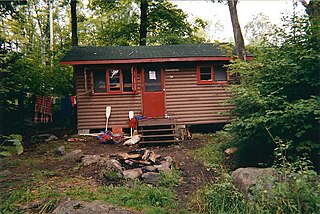
Big Doe Camp was a boys' residential summer camp located on Big Doe Lake not far from the village of Burk's Falls, Ontario.

Canoe Lake is a lake located in Algonquin Provincial Park in Nipissing District, Ontario, Canada. Canoe Lake is a major access point for many canoeists entering Algonquin Park as well as being home to many cottages. Important to note is that Canoe Lake is situated on the traditional territory of the Anishinaabeg, specifically the Chippewa, Ojibwa and Potawatomi peoples, under the terms of the Robinson-Huron Treaty #61 of 1850, and the Williams Treaties of 1923.

The Sturgeon River Provincial Park is a provincial park in northern Ontario, Canada, that protects about 70 kilometres (43 mi) long section of the Sturgeon River and its banks, from Woods Lake to the Sudbury-Nipissing District boundary. It was established in 1989 and expanded in 2005. It protects outstanding water routes that provide recreational canoe camping opportunities. Other activities include hunting and fishing.
YMCA Wanakita is a camp located on Koshlong Lake near Haliburton in central Ontario, Canada. It is run by the YMCA of Hamilton, Burlington and Brantford and attracts campers from throughout Ontario and sometimes internationally. The name "Wanakita" comes from a legend of the Wendat people.
Solace Provincial Park is a remote provincial park in Sudbury District, Ontario, Canada. It was established in 1985 and protects a series of lakes that provide backcountry canoeing opportunities. It is characterized by boreal forest, mostly jack pine conifer forest with mixed forest including white birch. The roadless park, with topography and scenery similar to the adjacent Lady Evelyn-Smoothwater Provincial Park, is considered as "one of the most isolated, wild places in Ontario."
Rock Lake is a lake located in Algonquin Provincial Park in Haliburton County, Ontario, Canada.


