Big East River

Last updated
Big East River
Big Bend at Arrowhead Provincial Park.jpg
Canada Ontario relief location map.jpg
Red pog.svg
Location of the mouth of the Big East River in Ontario
Location
CountryCanada
Province Ontario
RegionNortheastern Ontario
Districts
Physical characteristics
SourceEast End Lake
  locationHunter Township, Nipissing District
  coordinates 45°35′28″N78°48′49″W / 45.59111°N 78.81361°W / 45.59111; -78.81361
  elevation506 m (1,660 ft)
Mouth Lake Vernon, North Branch Muskoka River
  location
Huntsville, Muskoka District Municipality
  coordinates
45°20′04″N79°16′29″W / 45.33444°N 79.27472°W / 45.33444; -79.27472
  elevation
283 m (928 ft)
Basin features
River system Great Lakes Basin
Tributaries 
  rightLittle East River, Tonawanda Creek

The Big East River is a river in Muskoka District and Nipissing District in Northeastern Ontario, Canada. [1] [2] The river is in the Great Lakes Basin, is a left tributary of the Muskoka River, and flows from Algonquin Provincial Park to Huntsville.

Contents

The Big East River is an established canoe route. Its upper part is difficult to paddle, with low water levels in the summer. [3]

Geography

The Big East River begins at East End Lake in Algonquin Provincial Park in geographic Hunter Township, Nipissing District. [2] [4] It loops east and south to Red Lake in geographic Peck Township, turns southwest to West Harry Lake, then leaves the lake southwest over West Harry Lake Dam, through the Big Cedar Chutes, and enters geographic Finlayson Township.

The river passes from Algonquin Provincial Park into Big East River Provincial Park, through Finlayson Lake and over the former Finlayson Lake Dam (which was removed to allow the river to return to its natural riverine characteristics [5] ) and through the Finlayson Rapids, and enters Muskoka District at geographic Sinclair Township in the incorporated township of Lake of Bays. It continues southwest through the McBrien Rapids to Distress Lake, where it takes in the right tributary Tonawanda Creek, over an overflow weir (which replaced the former Distress Dam [5] ). From here the river widens, slows down, and meanders, with some shallow swifts. [3]

The river leaves Big East River Provincial Park, enters geographic Chaffey Township in the town of Huntsville, passes the Dyer Memorial on the right bank near the settlement of Williamsport, and enters a section of oxbows and loops with 35-metre-high (115 ft) sandbanks. [3] It passes Arrowhead Provincial Park on the right bank, takes in the right tributary Little East River, then straightens and deepens before flowing under Ontario Highway 11, and reaches its mouth at Lake Vernon. Lake Vernon flows via the North Branch Muskoka River, then the Moon River and Musquash River to Lake Huron.

Tributaries

  • Little East River (right)
  • Beaver Creek (right)
  • Rebecca Creek (left)
  • Raft Creek (right)
  • Tonawanda Creek (right)
  • Bear Creek (right)
  • Greenish Creek (right)
  • Cripple Creek (right)
  • Tasso Creek (left)
  • Beanpod Creek (right)
  • McRaney Creek (right)
  • Mink Creek (left)
  • Lulu Creek (right)
  • Lupus Creek (left)
  • Otterpaw Creek (right)

Big East River Provincial Park

Big East River Provincial Park
Location Lake of Bays
Coordinates 45°28′05″N79°04′58″W / 45.46806°N 79.08278°W / 45.46806; -79.08278 [6]
Area1,050 ha (4.1 sq mi) [7]
DesignationWaterway
Established2000
Governing body Ontario Parks
www.ontarioparks.ca/park/bigeastriver

Big East River Provincial Park is a provincial park in Lake of Bays Township, Ontario, Canada, established on August 10, 2000, as the first of Ontario’s Living Legacy’s new provincial parks. As a waterway class park, it protects the waters and 200-metre wide (660 ft) strips of land along both banks of the Big East River, from the western boundary of Algonquin Park to Arrowhead Provincial Park. The river in the park has "spectacular" sandy bluffs and numerous oxbows. [5] [7]

Big East River Provincial Park is a non-operating park, meaning that there are no facilities or services for visitors. [7] Low–impact recreational activities such as hiking, swimming, canoeing, kayaking, and nature–viewing are permitted and encouraged. [5]

More than 400 vascular plant species and over 90 bird species in some 18 vegetation environments are found within the park, including over 30 regionally or provincially rare species of plants and several rare bird species. [5]

See also

Related Research Articles

<span class="mw-page-title-main">York River (Ontario)</span> River in Ontario, Canada

The York River is a river in Renfrew County, Hastings County and Haliburton County in Ontario, Canada. The river is in the Saint Lawrence River drainage basin, and flows from the southern extension of Algonquin Provincial Park to the Madawaska River.

<span class="mw-page-title-main">Indian River (Muskrat River watershed)</span> River in Ontario, Canada

The Indian River is a river in Renfrew County and Nipissing District in Eastern and Northeastern Ontario, Canada. It is in the Saint Lawrence River drainage basin, and is a left tributary of the Muskrat River.

<span class="mw-page-title-main">Petawawa River</span> River in Ontario, Canada

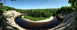
The Petawawa River is a river in the Saint Lawrence River drainage basin in Nipissing District and Renfrew County in eastern and northeastern Ontario, Canada. The river flows from Algonquin Provincial Park to the Ottawa River at the town of Petawawa, and is only one of two major tributaries of the Ottawa River to flow completely free. The river's name comes from the Algonquian for "where one hears a noise like this", which refers to its many rapids.

<span class="mw-page-title-main">Bonnechere River</span> River in Ontario, Canada

The Bonnechere River is a river in the Saint Lawrence River drainage basin in Nipissing District and Renfrew County in eastern and northeastern Ontario, Canada. The river flows from Algonquin Provincial Park to the Ottawa River east and north of the town of Renfrew. The river's name is thought to come from the French "bonne chère" meaning "good cheer".

<span class="mw-page-title-main">Opeongo River</span> River in Ontario, Canada

The Opeongo River is a river in the Saint Lawrence River drainage basin in Nipissing District in northeastern Ontario, Canada. The river is entirely within Algonquin Provincial Park and Opeongo River Provincial Park, except for a small portion around Victoria Lake, and is a left tributary of the Madawaska River.

<span class="mw-page-title-main">Opeongo Lake</span>

Opeongo Lake is a lake in the Saint Lawrence River drainage basin in the geographic townships of Bower, Dickson, Preston and Sproule in the Unorganized South Part of Nipissing District in Northeastern Ontario, Canada. It is the largest lake in Algonquin Provincial Park and the source of the Opeongo River. The lake's name comes from the Algonquian word opeauwingauk meaning "sandy narrows".

<span class="mw-page-title-main">Barron River (Ontario)</span> River in Ontario, Canada

The Barron River is a river in the Saint Lawrence River drainage basin in Nipissing District and Renfrew County, Ontario, Canada. It flows from Clemow Lake in northern Algonquin Provincial Park and joins the Petawawa River, whose southern branch it forms, in the municipality of Laurentian Hills, near the municipality of Petawawa.

<span class="mw-page-title-main">North Tea Lake</span> Lake in Ontario, Canada

North Tea Lake is a lake in the Ottawa River drainage basin in the geographic townships of Ballantyne and Wilkes in the Unorganized South Part of Nipissing District in Northeastern Ontario, Canada. It is on the Amable du Fond River and lies in the northwest of Algonquin Provincial Park. The lake is a popular destination for canoeists.

Snowshoe Lake is a lake in the Lake Huron drainage basin in Algonquin Provincial Park in Nipissing District, Ontario, Canada. It is about 790 metres (2,592 ft) long and 100 metres (328 ft) wide, and lies at an elevation of 466 metres (1,529 ft). The primary outflow is an unnamed creek to West Harry Lake, which flows via the Big East River, the Muskoka River and the Moon and Musquash rivers into Lake Huron.

The Redstone River is a river in the municipality of Dysart et al, Haliburton County in central Ontario, Canada that flows from southern Algonquin Provincial Park to the Gull River.

<span class="mw-page-title-main">Englehart River</span> River in Ontario, Canada

The Englehart River is a river in Timiskaming District in northeastern Ontario, Canada. It is in the Saint Lawrence River drainage basin and is a right tributary of the Blanche River.

Tonawanda Creek is a creek in Central Ontario, Canada. It is part of the Great Lakes Basin and is a right tributary of the Big East River.

<span class="mw-page-title-main">Grand Lake (Nipissing District)</span>

Grand Lake is a lake in the Ottawa River drainage basin in the geographic townships of Barron and Stratton in the Unorganized South Part of Nipissing District in Northeastern Ontario, Canada.

The Crow River is a river in the Saint Lawrence River drainage basin in the Unorganized South Part of Nipissing District in northeastern Ontario, Canada. The river lies entirely within Algonquin Provincial Park and is a right tributary of the Petawawa River.

The Little Madawaska River is a river in the Saint Lawrence River drainage basin in the Unorganized South Part of Nipissing District in northeastern Ontario, Canada. The river is entirely within Algonquin Provincial Park, and is a right tributary of the Petawawa River and not a tributary of the nearby Madawaska River.

The Nipissing River is a river in the Saint Lawrence River drainage basin in the Unorganized South Part of Nipissing District in northeastern Ontario, Canada. The river is entirely within Algonquin Provincial Park, and is a left tributary of the Petawawa River.

The Tim River is a river in the Saint Lawrence River drainage basin in the Unorganized South Part of Nipissing District in northeastern Ontario, Canada. The river is entirely within Algonquin Provincial Park, and is a left tributary of the Petawawa River.

<span class="mw-page-title-main">Groundhog River</span> River in Northeastern Ontario, Canada

The Groundhog River is a river in Cochrane District and Sudbury District in Northeastern Ontario, Canada. The river is in the James Bay drainage basin and is a left tributary of the Mattagami River.

Depot Creek is a river in Nipissing District in Northeastern Ontario, Canada. It is in the Saint Lawrence River drainage basin, is a tributary of Grand Lake on the Barron River, and lies entirely within Algonquin Provincial Park.

Potter Creek is a stream in the Unorganized South Part of Nipissing District in Northeastern Ontario, Canada. It is a tributary of Canoe Lake, is in the Lake Huron drainage basin, and lies within Algonquin Provincial Park.

References

  1. "Big East River". Geographical Names Data Base . Natural Resources Canada . Retrieved 2011-11-13.
  2. 1 2 "Big East River". Atlas of Canada . Natural Resources Canada. 2010-02-04. Retrieved 2011-11-13. Shows the course of the river highlighted on a map.
  3. 1 2 3 Callan, Kevin (18 September 2020). "Big East River an underappreciated gem for paddlers". Toronto Star . Retrieved 1 February 2024.
  4. McMurtrie, Jeffrey (2008). "Algonquin Provincial Park and the Haliburton Highlands". Wikimedia Commons. Archived from the original on 2011-06-29. Retrieved 2011-11-13.
  5. 1 2 3 4 5 "Big East River Provincial Park Management Statement". Ontario Ministry of Natural Resources. 8 December 2000. Retrieved 1 February 2024.
  6. "Big East River Provincial Park". Geographical Names Data Base . Natural Resources Canada . Retrieved 1 February 2024.
  7. 1 2 3 "Big East River Provincial Park". www.ontarioparks.com. Ontario Parks. Retrieved 1 February 2024.

Sources