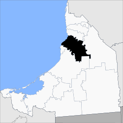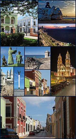
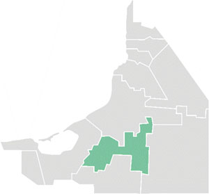
San Francisco de Campeche, 19th c., also known simply as Campeche, is a city in Campeche Municipality in the Mexican state of Campeche, on the shore of the Bay of Campeche in the Gulf of Mexico. Both the seat of the municipality and the state's capital, the city had a population of 220,389 in the 2010 census, while the municipality had a population of 259,005.

Champotón is a small city in Champotón Municipality in the Mexican state of Campeche, located at 19°21′N90°43′W, about 60 km south of the city of Campeche where the small Champotón river meets the coast of the Gulf of Mexico. At the 2010 census it had a population of 30,881.
Escárcega is a small city in the Mexican state of Campeche, located at 18.62°N 90.74°W in the central part of the state. As of 2010, the city of Escárcega had a population of 29,477.

Dzitbalché is a large town in the extreme northern part of the Mexican state of Campeche. It is located at 20.32°N 90.05°W and serves as the municipal seat for the municipality of the same name. As of 2010, Dzitbalché had a population of 11,686, up from 10,951 at the 2005 census, making it the sixth-largest community in the state. Before the creation of the municipality of Dzitbalché on 1 January 2021, it was the second-largest community in the municipality of Calkiní.

Comitán is the fourth-largest city in the Mexican state of Chiapas. It is the seat of government of the municipality of the same name.

Campeche, officially Estado Libre y Soberano de Campeche, is one of the 31 states which, with Mexico City, make up the 32 Federal Entities of Mexico. Located in southeast Mexico, it is bordered by the states of Tabasco to the southwest, Yucatán to the northeast, Quintana Roo to the east, and by the Petén department of Guatemala to the south. It has a coastline to the west with the Gulf of Mexico. The state capital, also called Campeche, was declared a World Heritage Site in 1997. The formation of the state began with the city, which was founded in 1540 as the Spanish began the conquest of the Yucatán Peninsula. The city was a rich and important port during the colonial period, but it declined after Mexico's independence. Campeche was part of the province of Yucatán but split off in the mid-19th century, mostly due to political friction with the city of Mérida. Much of the state's recent economic revival is due to the discovery of petroleum offshore in the 1970s, which has made the coastal cities of Campeche and Ciudad del Carmen important economic centers. The state has important Mayan and colonial sites; however, these are not as well-known or visited as others in the Yucatán.

Coatzacoalcos is a major port city in the southern part of the Mexican state of Veracruz, mostly on the western side of the Coatzacoalcos River estuary, on the Bay of Campeche, on the southern Gulf of Mexico coast. The city serves as the municipal seat of the municipality of the same name. The city had a 2020 census population of 212,540, making it the third-largest city in the state after Veracruz and Xalapa. The municipality covers a surface area of 471.16 km2 (181.916 sq mi) and reported a population of 310,698 persons. The municipality population in 2015 was 319,187 a decrease of 9% over 2020.
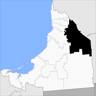
Campeche is a state on the Yucatán Peninsula in Mexico that is divided into thirteen municipalities. According to the 2020 Mexican census, Campeche is the third least populous state with 928,363 inhabitants and the 17th largest by land area spanning 57,693.59 square kilometres (22,275.62 sq mi).
Ocosingo is a city and its surrounding municipality of the same name in the Mexican state of Chiapas.

Las Margaritas is a city, and the surrounding municipality of the same name, in the Mexican state of Chiapas. The municipal seat is located some 25 km to the northeast of Comitán de Domínguez, while the municipality extends to the east as far as the border with Guatemala. Part of the Lagunas de Montebello National Park is in the municipality's territory.

Calkiní is one of the 11 municipalities in the Mexican state of Campeche. It is situated at the northern tip of the state, on the central western coast the Yucatán Peninsula. The municipal seat, and largest settlement, is the city of Calkiní.

Carmen is one of the 11 municipalities that make up the Mexican state of Campeche. It is situated at the south-west of the state, on and around the Laguna de Términos. The municipal seat and largest settlement is Ciudad del Carmen. As of 2015, the population was 248,303.

Candelaria is one of the 11 municipalities that make up the Mexican state of Campeche. It is situated at the south of the state, and the municipal seat, and largest settlement, is the city of Candelaria. As of 2010, the population was 41,194.
Hopelchén is one of the 11 municipalities in the Mexican state of Campeche. It is situated inland in the north of the state. The municipal seat, and largest settlement, is the city of Hopelchén.

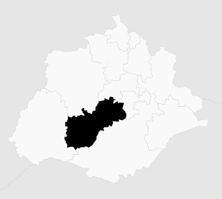
Escárcega is one of the 11 municipalities in the Mexican state of Campeche. The municipal seat, and largest settlement, is the city of Escárcega.
Jesús María is a municipality in the Mexican state of Aguascalientes. It stands at 21°58′N102°21′W. As of 2010, the municipality had a total population of 99,590.

Hecelchakán is one of the 11 municipalities in the Mexican state of Campeche. The municipal seat, and largest settlement, is the city of Hecelchakán.
Tlahualilo is one of the 39 municipalities of Durango, in north-western Mexico. The municipal seat lies at Tlahualilo de Zaragoza. The municipality covers an area of 3,709.8 km².

Champotón Municipality is a municipality within the state of Campeche, including the city of Champotón and the surrounding area. In 2010 the municipality of Champotón had a population of 83,021 inhabitants. It has an areal extent of 6,088.28 km² and includes the significant community of Seybaplaya.
The following is a timeline of the history of the city of Campeche, Mexico.