Candelaria Municipality

Last updated
Candelaria
Cande.jpg
Candelaria en Campeche.svg
Location of Candelaria
Mexico Campeche location map.svg
Red pog.svg
Candelaria
Mexico States blank map.svg
Red pog.svg
Candelaria
Coordinates: 18°0′N90°45′W / 18.000°N 90.750°W / 18.000; -90.750
CountryFlag of Mexico.svg  Mexico
State Campeche
Municipal seat Candelaria
Government
   Municipal president (2006–09)
Area
  Total5,518.5 km2 (2,130.72 sq mi)
Elevation
49 m (161 ft)
Population
 (2015)
  Total43,879
  Density8.0/km2 (21/sq mi)
Time zone UTC−6 (Central (US Central))
  Summer (DST) UTC−5 (Central)
Created19 June 1998
Website www.candelaria.gob.mx/

Candelaria is one of the 11 municipalities that make up the Mexican state of Campeche. It is situated at the south of the state, and the municipal seat, and largest settlement, is the city of Candelaria. As of 2010, the population was 41,194.

Contents

The name "Candelaria" is in reference to the Río Candelaria, a river which drains the region.

History

On 25 April 1984, the State Congress heard a request made by the residents of the region for it to be established as an autonomous municipality. The municipality of Candelaria was created by the Congress on 19 June 1998.

Geography

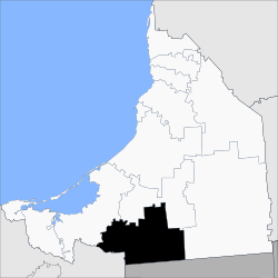
The municipality of Candelaria borders to the north with the municipality of Escárcega; to the south with Guatemala and the state of Tabasco; to the east with the municipality of Calakmul, and to the west with the municipality of Carmen. It covers a total surface area of 5,518.55 km².

The region is a part of a large plain. The lowest altitude is 10 meters above sea level, and the highest is 100 meters above sea level. The plain is generally flat with moderate hills. A large river, the Candelaria River, runs through the municipality.

Hydrography

The Candelaria region is part of the Grijalva-Usumacinta hydrological system, which includes the Candelaria River. The Candelaria River begins in the Petén Department in Guatemala, (where it is called the San Pedro River), and empties into the Boca de Pargos, in the Carmen Lagoon. The river is 402 km long. Its primary tributaries are the San Pedro River and the Caribbean River, while its primary sub-tributaries include these streams: Las Golondrinas, Ojo de Agua, Pejelagarto, Arroyo Negro, and La Esperanza, the latter being the longest. The Candelaria River has several waterfalls. Some of these include the Waterfall of Death, Grande Waterfall, and Bull Waterfall.

Climate

This region varies between a warm humid climate and a rainy, warm, Humid subtropical climate, with monsoon rains occurring during the summer. The average annual temperature is 25 degrees Celsius. Annual precipitation in the Candelaria region is approximately 1700 mm, from the period of May to December, with much of that rainfall occurring in the months of September and October.

Demographics

According to the 2005 Population and Housing count, the municipality has a total of 49,850 inhabitants.

As of 2010, the city of Candelaria had a population of 9,812.[1] Other than the city of Candelaria, the municipality had 1,401 localities, the largest of which (with 2010 populations in parentheses) were: Benito Juárez Uno (1,281) and El Naranjo (1,065), classified as rural.

Related Research Articles

<span class="mw-page-title-main">Quetzaltenango</span> Municipality and city in Guatemala

Quetzaltenango is both the seat of the namesake Department and municipality, in Guatemala.

<span class="mw-page-title-main">Escuintla</span> Municipality in Guatemala

Escuintla is an industrial city in Guatemala, its land extension is 4384 km², and it is nationally known for its sugar agribusiness. Its capital is a minicipality with the same name. Citizens celebrate from December 6 to 9 with a small fair in honor to The Immaculate Conception.

<span class="mw-page-title-main">Campeche</span> State of Mexico

Campeche, officially the Free and Sovereign State of Campeche, is one of the 31 states which make up the 32 Federal Entities of Mexico. Located in southeast Mexico, it is bordered by the states of Tabasco to the southwest, Yucatán to the northeast, Quintana Roo to the east, and by the Petén department of Guatemala to the south. It has a coastline to the west with the Gulf of Mexico. The state capital, also called Campeche, was declared a World Heritage Site in 1997. The formation of the state began with the city, which was founded in 1540 as the Spanish began the conquest of the Yucatán Peninsula. The city was a rich and important port during the colonial period, but it declined after Mexico's independence. Campeche was part of the province of Yucatán but split off in the mid-19th century, mostly due to political friction with the city of Mérida. Much of the state's recent economic revival is due to the discovery of petroleum offshore in the 1970s, which has made the coastal cities of Campeche and Ciudad del Carmen important economic centers. The state has important Mayan and colonial sites; however, these are not as well-known or visited as others in the Yucatán.

<span class="mw-page-title-main">Santiago Rodríguez Province</span> Province of the Dominican Republic

Santiago Rodríguez is a province in the northwest region of the Dominican Republic. It was split from Monte Cristi in 1948. The Santiago Rodríguez province has the Monte Cristi and Valverde provinces to the north, the Santiago province to the east, the San Juan and Elías Piña provinces to the south and the Dajabón province to the west.

<span class="mw-page-title-main">Otatitlán</span> Town and municipality in Veracruz, Mexico

Otatitlán is a town and municipality in the Mexican state of Veracruz, in the south of the state along the border with the state of Oaxaca. The town is best known for its large black image of a crucified Christ, one of three notable images of this type. Most of the population in Otatitlán is poor and the area is dedicated to agriculture, especially sugar cane and bananas.

<span class="mw-page-title-main">Calakmul Municipality</span> Municipality in Campeche, Mexico

Calakmul is a municipality in the Mexican state of Campeche, situated in the central part of the Yucatán Peninsula.

Malacatán is a town and municipality in the San Marcos department of Guatemala, located to the west of San Marcos town. It is fairly close to the border with Mexico - the border-crossing point is in the nearby village of El Carmen.

<span class="mw-page-title-main">Magdalena Tequisistlán</span> Municipality and town in Oaxaca, Mexico

Magdalena Tequisistlán is a town and municipality in the Mexican state of Oaxaca, located 470 km (290 mi) southeast of Mexico City. It is part of the Tehuantepec District in the west of the Istmo Region. The town was founded in 1410 under the present name. In the Chontal language it was known as "Maadú".

<span class="mw-page-title-main">Ciudad Valles</span> City and municipality in San Luis Potosí, Mexico

Ciudad Valles is the second-largest city in the Mexican state of San Luis Potosí. It is located in the eastern part of the state, in the cultural region of Huasteca. The city is also the municipal seat of the surrounding municipality of the same name. It had a 2020 census population of 136,351.

<span class="mw-page-title-main">Mérida Municipality</span> Municipality in Yucatán, Mexico

Mérida Municipality is one of the 106 municipalities in the Mexican state of Yucatán containing (858.41 km2) of land with the head or seat being the city of Mérida. Because the archaeological remains of the Maya reminded the Spaniards of the ancient city of Mérida, Spain, which was marked by Roman archaeological sites, they renamed the site of T-hó after the Spanish city.

<span class="mw-page-title-main">Huauchinango</span> City in Puebla, Mexico

Huauchinango is a city in the far north of the state of Puebla in central Mexico. It is located in the rugged Sierra Norte de Puebla mountain region, filled with peaks, ravines and rivers that form waterfalls. The city is home to a locally venerated image called the Señor del Santo Entierro and also to the area's main commercial fair, the Feria de las Flores, which promotes the area's flower production, especially that of azaleas. It serves as the municipal seat for the surrounding municipality of the same name.

Huautla de Jimenez is a town and municipality in the Mexican state of Oaxaca. It is part of the Teotitlán District in the north of the Cañada Region.

<span class="mw-page-title-main">Jilotepec de Abasolo</span> City in the State of Mexico, Mexico

Jilotepec de Molina Enríquez, known as Jilotepec de Abasolo until 1986, and commonly known as Jilotepec, is a city located in the northwest zone of the State of Mexico in Mexico. The name comes from Náhuatl, meaning "hill of corncobs". It is the municipal seat and largest city of the municipality of Jilotepec. It is located in hilly and forested terrain about an hour's drive from Mexico City and the state capital of Toluca, 40 minutes from San Juan del Río, 30 minutes from Tula and 20 minutes from Tepeji. The Mexico City–Querétaro highway and the new Transoceanic Freeways that unite the coasts of Mexico from Veracruz to Michoacán converge within its territory.

<span class="mw-page-title-main">Carmen Municipality</span> Municipality in Campeche, Mexico

Carmen is one of the 11 municipalities that make up the Mexican state of Campeche. It is situated at the south-west of the state, on and around the Laguna de Términos. The municipal seat and largest settlement is Ciudad del Carmen. As of 2015, the population was 248,303.

<span class="mw-page-title-main">Palenque, Chiapas</span> Municipality and city in Chiapas, Mexico

Palenque is a city and municipality located in the north of the state of Chiapas, Mexico. The city was named almost 200 years before the nearby Mayan ruins were discovered in the 18th century. The area has a significant indigenous population, mostly of the Ch'ol people, a Mayan descendant. The city is the only urban area in a municipality of over 600 communities, and is surrounded by rainforest. Deforestation has had dramatic effects on the local environment, with howler monkeys occasionally seen in the city as they seek food. While most of the municipality's population is economically marginalized, working in agriculture, the Palenque archeological site is one of the most important tourist attractions for the area and the state of Chiapas. It is the poorest major city in the state of Chiapas.

<span class="mw-page-title-main">Catemaco (municipality)</span> One of the 212 municipalities that make up the Mexican state of Veracruz

Catemaco Municipality is one of the 212 municipalities that make up the Mexican state of Veracruz. It is in the state's Los Tuxtlas. The municipal seat is the city of Catemaco.

San Juan Cotzocon is a town and municipality in Oaxaca in south-western Mexico. It is part of the Sierra Mixe district within the Sierra Norte de Oaxaca Region.

<span class="mw-page-title-main">San Pedro Mixtepec, Juquila</span> Municipality and town in Oaxaca, Mexico

San Pedro Mixtepec is a town and municipality in Oaxaca in south-western Mexico. It is part of the Juquila District in the center of the Costa Region.

San Pedro Tapanatepec is a town and municipality in Oaxaca in southeastern Mexico. It is part of the Juchitán District in the west of the Istmo de Tehuantepec region.

<span class="mw-page-title-main">Juquila District</span> District in Oaxaca, Mexico

Juquila District is located in the center of the Costa Region of the State of Oaxaca, Mexico, on the Pacific coast. It has an area of 5,055 km2. As of 2005 it had a total population of 134,365 of whom 33,106 spoke an indigenous language. Economic activities include agriculture and tourism. The Santuario (Sanctuary) de Juquila is a major attraction.

References