
The Dolomites are a mountain range located in northeastern Italy. They form part of the Southern Limestone Alps and extend from the River Adige in the west to the Piave Valley in the east. The northern and southern borders are defined by the Puster Valley and the Sugana Valley. The Dolomites are located in the regions of Veneto, Trentino-Alto Adige/Südtirol and Friuli Venezia Giulia, covering an area shared between the provinces of Belluno, Vicenza, Verona, Trentino, South Tyrol, Udine and Pordenone.

The Province of Brescia is a Province in Lombardy, northern Italy. It has a population of some 1,265,964 and its capital is the city of Brescia.
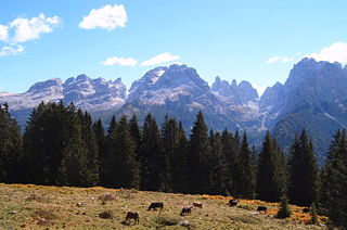
The Brenta Group or Brenta Dolomites is a mountain range, and a subrange of the Rhaetian Alps in the Southern Limestone Alps mountain group. They are located in the Province of Trentino, in northeastern Italy. It is the only dolomitic group west of river Adige. Therefore, geographically, they have not always been considered a part of the Dolomites mountain ranges. Geologically, however, they definitely are - and therefore sometimes called the "Western Dolomites". As part of the Dolomites, the Brenta Group has been officially recognized as UNESCO World Heritage Site under the World Heritage Convention.
The Adamello-Presanella Alps Alpine group is a mountain range in the Southern Limestone Alps mountain group of the Eastern Alps. It is located in northern Italy, in the provinces of Trentino and Brescia. The name stems from its highest peaks: Adamello and Presanella.

Saint Romedius was a son of the Tyrolese count of Thaur in the Inn valley near Innsbruck). Though the son of a nobleman, as a young man he withdrew to a rock cave in order to meditate. After the death of his parents, he gave away all of his possessions and established himself in the Val di Non in Trentino.

Val Camonica is one of the largest valleys of the central Alps, in eastern Lombardy, Italy. It extends about 90 kilometres (56 mi) from the Tonale Pass to Corna Trentapassi, in the commune of Pisogne near Lake Iseo. It has an area of about 1,335 km2 (515 sq mi) and 118,323 inhabitants.

Tonale Pass (el. 1883 m./6178 ft.) is a high mountain pass in northern Italy across the Rhaetian Alps, between Lombardy and Trentino.

The Sole Valley is a valley in Trentino, northern Italy.

Presanella is a mountain in the Adamello-Presanella range of the Italian Alps of northern Italy. Presanella has an elevation of 3,558 meters and is located in the Adamello Brenta National Park within the Trentino province of Italy.

Andalo is a comune (municipality) in Trentino in north Italy, with some 1,000 inhabitants in 2010. Despite its size, it is the seat of the newly created Comunità di Valle dell'Altopiano della Paganella.

The Alpine Brigade "Tridentina" was a light Infantry brigade of the Italian Army, specializing in mountain warfare. Its core units were Alpini, the mountain infantry corps of the Italian Army, that distinguished itself in combat during World War I and World War II. The Alpine Brigade "Tridentina" carried on the colours and traditions of the WWII 2nd Alpine Division "Tridentina".

The Chiese, also known in the Province of Brescia as the Clisi, is a 160-kilometre (99 mi) Italian river that is the principal immisary and sole emissary of the sub-alpine lake Lago d’Idro, and is a left tributary of the Oglio.

The Bionda dell'Adamello is an indigenous breed of domestic goat from the Val Camonica in the province of Brescia, in Lombardy in northern Italy. It takes its name from the massif of the Adamello, part of the Adamello-Presanella subsection of the Rhaetian Alps. It is raised mainly in the Val Camonica, the Val Saviore and the mountains of Brescia; some are found in neighbouring areas of the provinces of Bergamo to the west and Trento to the east. It was in the past known simply as the Capra Bionda or as the Mustàscia.

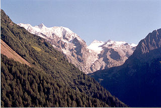
Adamello is a mountain in Lombardy, Italy. With an elevation of 3,539 metres (11,611 ft), it is the second highest peak of the Adamello-Presanella Alps. It is located in Valcamonica, Lombardy.

The Southern Rhaetian Alps are a mountain range in the southern part of the Alps.

Vivione Pass Passo is a mountain pass that links Schilpario in Val di Scalve with Paisco Loveno in Val Camonica. The road was built during World War I to supply troops in the nearby Adamello. Vivione Pass has a height of 1828 m and is usually closed for snow from December to May, the road is not larger than 2 meters but is paved.

The Fiemme Mountains, sometimes also the Fleimstal Alps or Fiemme Dolomites, are a mountain range of the Southern Limestone Alps in the Italian region of Trentino-South Tyrol. The range was named after the Fiemme Valley.
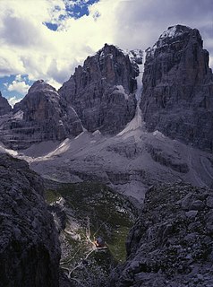
Cima Tosa is a mountain in the Brenta group, a subgroup of the Rhaetian Alps in the Italian Region of Trentino-Alto Adige, with a reported height of 3,173 metres (10,410 ft). With this elevation, the prominence of Cima Tosa would amount up to 1,521 meters above the reference point at Passo Carlo Magno near Madonna di Campiglio at 1,652 meters. Cima Tosa therefore qualifies as one of Europe's ultra prominent peaks. The mountain rises above Val Rendena with its 800-metre (2,600 ft) vertical north face with a steep couloir called Canalone della Tosa dividing it from its ante-peak, Crozzon di Brenta. The summit is topped by a snow cupola above the rock face, almost like a shaven head, hence the name Cima Tosa. The south-eastern side descends in a series of snowy terraces and vertical rock pillars.
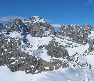
Cima Brenta is a mountain in the Brenta group, a subgroup of the Rhaetian Alps in the Italian Region of Trentino-Alto Adige, with a reported height of 3,150 metres (10,330 ft). The mountain rises imposingly up between the rock towers and pinnacles of the central Brenta Group. A sharp ridge connects the mountain on its southern side to the Spallone die Massodi. The northern ridge steeply descends towards Bocca del Tuckett. Towards north west a slender couloir descends all the way from the top towards the Vedretta di Brenta Inferiore, the mountain's 'lower' glacier. Large shouldering formations extend towards the west, culminating in the Cima Mandrone and the Punti di Campiglio, and northwest, culminating in the Cima Massari. Above these formations a glacier, the Vedretta di Brenta Superiore, the 'upper' glacier descends the mountain, being cut off by a vertical precipice over the Vedretta di Brenta Inferiore. On the eastern side the mountain rises up with an imposing 700-meter high vertical rock face with on its left side a distinct orange-like color. Above this lies a horizontal ledge, the Cengia Garbari, on which the Via delle Bocchette Alte proceeds. The actual mountain has two summits that are some 250 meters apart, of which the eastern top reaches the highest altitude. The glaciers, vedrette, have been shrinking steadily over the last decades as a result of climate change. The historical name Cima Brenta was not always as evident as it is today. The toponymy of these parts was largely established by Nepomuceno Bolognini. The mountain, somehow, became a place where nationalistic sentiments were demonstrated. In 1889 the Austro-Hungarian authorities decided to rename the mountain to Kaiser Franz Josef-Spitze. The name never caught on -not even in German literature. When the occasion occurred to raise a large yellow-black imperial flag on the summit, fully visible from Val Rendena as well as from Molveno, local guide Giuseppe 'Bepaccia' Zeni and some companions climbed the mountain to take it down. In 1912, on the other hand, the Italian flag was hoisted by irredentists on Cima Brenta, deliberately just before the first snow fall, so that the flag remained visible until the next summer. Around 1953 electricity company SISM, predecessor of ENEL proposed to build a cable car trajectory from Molveno to the top of Cima Brenta. The plans were abandoned and in 1967 the mountain became protected as part of the Parco Naturale Adamello-Brenta.

The Alpini Battalion "Val Brenta" is an inactive battalion of the Italian Army's mountain infantry speciality, the Alpini, which distinguished itself in combat during World War I and World War II.
