Canal Area, San Rafael, California

Last updated
Aerial view of the San Rafael Canal, looking west. The northern tip of the Canal Area is on the left, with Pickleweed Park in the central foreground. San Rafael California Canal Area aerial view.jpg
Aerial view of the San Rafael Canal, looking west. The northern tip of the Canal Area is on the left, with Pickleweed Park in the central foreground.

The Canal Area comprises two neighborhoods of San Rafael, California, designated by the city as the "Canal Waterfront" and the "Canal." The Canal Area is bounded on the east by San Francisco Bay, on the north by the San Rafael Canal and on the south and west by Highways 101 and I-580 and by San Quentin Ridge. Land use is split almost evenly between residential and non-residential (commercial/industrial) uses. [1] The Canal Area provides a substantial portion of the low-income housing in Marin County, one of the most affluent counties in the United States, along with Marin City. It is also the location of transportation and waste management facilities serving Marin County and the North Bay. The Canal area is also one of the most segregated neighborhoods in Marin County, with more than a 90% Hispanic population and less than 5% white non-Hispanic population. [2]

Contents

Demographics and housing

Most of San Rafael's low-income residents live in the Canal Area, along with many affluent residents. There is at least one concern (on Harbor Way) that rents slips for boats that people can live aboard legally. The more affluent residents live in the houses constructed in the 1960s right on the Canal and in two housing developments in the eastern part of the Canal's residential area: Baypoint Lagoons (constructed in the late 1990s) and Spinnaker Point (constructed earlier). Some real-estate agents refer to these two developments as being in "East San Rafael", to avoid the stigma of the name "Canal Area". [ citation needed ] This area provides a location for workers who hold low-income jobs that are essential to the functioning of the community to live close to their place of employment. Although the majority of residents in this area are low-income workers, most of the apartments in which they live are neither subsidized nor less expensive than comparable apartments elsewhere in San Rafael.

Health Inequities

About 46.8% of the residents in Canal are living below 200% of the federal income and poverty level. [3] Because of this Canal residents spend more than 30% of their income on rent. [3] In 2020 this overcrowding caused a health inequity that not many foresaw. The Canal area saw a 20% COVID-19 positivity rate, which was more than the county average. [4] This made very clear that the residents of this area face many detrimental effects of societal issues. Nearly more than half of the COVID-19 cases in the county were concentrated in this area. [4] During COVID-19 many of the residents of the Canal area were also essential workers which is what contributed to the high COVID cases within this area. [4] These health inequities in Marin County are of importance because the residents of the area oftentimes don't have access to healthcare, and actually 36% of residents don't have health insurance. [3] But in Canal this isn't the only health inequity that is present. Canal residents are estimated to live nine years less than residents of Ross, California which is only about a 15-minute drive from Canal. [2]

Parks and public facilities

Between the newer housing developments and the Bay is a paved path called Shoreline Park, which is a scenic place to take a walk or a bike ride. Along with a bike path owned by the Spinnaker Point Homeowner's Association (which forms the West side of the square), Shoreline Park forms a square 0.25 miles (400 m) long and 0.25 miles (400 m) wide. The easiest way to visit Shoreline Park is to visit Pickleweed Park, then to walk east along the north side of the square. Pickleweed Park is home to a large community center and to soccer fields and a playground.

There are many dozen, perhaps hundreds, of stores, shops, offices and other commercial operations in the West and the South of the area (including most of San Rafael's auto-body shops). Country Club Bowl, Marin County's only surviving bowling center, is located here.

Large land users

Industrial Light and Magic occupied many tens of thousands of square feet of office space here and in 1997 built a "main stage" here for the production of movie special effects. The main stage is still in use, but most of the office space was moved to San Francisco in 2005.

Transportation and waste processing facilities

The southeastern portion of the Canal Area, between I-580 and San Quentin Ridge, is the base for several transportation and waste processing facilities serving large portions of Marin County. They include:

Closed landfills

The "East San Rafael" area (the eastern portion of the Canal Area between the Bay and San Quentin Ridge), was home to most of the garbage disposal sites in central Marin County, including the following (links are to the California Integrated Waste Management Board, Solid Waste Information System, which is continuously updated):

See also

Related Research Articles

<span class="mw-page-title-main">San Francisco Bay</span> Shallow estuary on the coast of California, United States

San Francisco Bay is a large tidal estuary in the U.S. state of California, and gives its name to the San Francisco Bay Area. It is dominated by the cities of San Francisco, San Jose, and Oakland.

<span class="mw-page-title-main">Richmond, California</span> City in California, United States

Richmond is a city in western Contra Costa County, California, United States. The city was incorporated on August 3, 1905, and has a city council. Located in the San Francisco Bay Area's East Bay region, Richmond borders San Pablo, Albany, El Cerrito and Pinole in addition to the unincorporated communities of North Richmond, Hasford Heights, Kensington, El Sobrante, Bayview-Montalvin Manor, Tara Hills, and East Richmond Heights, and for a short distance San Francisco on Red Rock Island in the San Francisco Bay.

<span class="mw-page-title-main">Marin County, California</span> County in California, United States

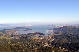
Marin County is a county located in the northwestern part of the San Francisco Bay Area of the U.S. state of California. As of the 2020 census, the population was 262,231. Its county seat and largest city is San Rafael. Marin County is across the Golden Gate Bridge from San Francisco, and is included in the San Francisco–Oakland–Berkeley, CA Metropolitan Statistical Area.

<span class="mw-page-title-main">San Rafael, California</span> City in California, United States

San Rafael is a city and the county seat of Marin County, California, United States. The city is located in the North Bay region of the San Francisco Bay Area. As of the 2020 U.S. census, the city's population was 61,271, up from 57,713 in 2010.

<span class="mw-page-title-main">Santa Venetia, California</span> Census-designated place in California, United States

Santa Venetia is a census-designated place (CDP) in Marin County, California, United States. It is located 1.5 miles (2.4 km) north of downtown San Rafael, at an elevation of 56 feet (17 m). The population was 4,289 at the 2020 census.

<span class="mw-page-title-main">Locally unwanted land use</span> High-externality areas

In land-use planning, a locally unwanted land use (LULU) is a land use that creates externality costs on those living in close proximity. These costs include potential health hazards, poor aesthetics, or reduction in home values. LULUs often gravitate to disadvantaged areas such as slums, industrial neighborhoods and poor, minority, unincorporated or politically under-represented places that cannot fight them off.

<span class="mw-page-title-main">Richardson Bay</span> Arm of San Francisco Bay

Richardson Bay is a shallow, ecologically rich arm of San Francisco Bay, managed under a Joint Powers Agency of four northern California cities. The 911-acre (369 ha) Richardson Bay Sanctuary was acquired in the early 1960s by the National Audubon Society. The bay was named for William A. Richardson, early 19th century sea captain and builder in San Francisco. It contains both Strawberry Spit and Aramburu Island.

San Quentin is a small unincorporated community in Marin County, California, United States. It is located west of Point San Quentin, at an elevation of 30 feet.

<span class="mw-page-title-main">India Basin, San Francisco</span> Place

India Basin is a neighborhood, named after the body of water, in the southeastern part of San Francisco, California, considered to be part of the larger Bayview–Hunters Point neighborhood.

<span class="mw-page-title-main">Point Isabel Regional Shoreline</span> Multi-use park

Point Isabel Regional Shoreline in Richmond, California, is operated by East Bay Regional Park District, and is a multi-use park for joggers, windsurfers, kayakers, photographers, picnickers, and people walking dogs. It has access for pedestrians and via public transit, private vehicles, and bikes. It also features a concession offering food for people and grooming for pets. A longtime community organization and nonprofit, Point Isabel Dog Owners and Friends (PIDO), is active in the maintenance and improvement of the park.

<span class="mw-page-title-main">César Chávez Park</span> City park of Berkeley, California

César Chávez Park is a 90 acres (36 ha) city park of Berkeley, California named after César Chávez. It can be found on the peninsula on the north side of the Berkeley Marina in the San Francisco Bay and is adjacent to Eastshore State Park.

<span class="mw-page-title-main">San Rafael Creek</span> River in California, United States

San Rafael Creek is a watercourse in Marin County, California, United States that discharges to San Rafael Bay, a small embayment of the San Francisco Bay. The mouth of San Rafael Creek is a channelized estuary through an industrial area. San Rafael Creek has a designation under Federal Law Section 303(d) as impaired by diazinon, the principal pollutant causing impairment designations for streams discharging to San Pablo Bay, which is the northern arm of San Francisco Bay. In September 2007, the organization Save The Bay designated San Rafael Creek as one of the top ten "worst trash hot spot" waterways flowing into the San Francisco Bay. The channel portion of San Rafael Creek below the Grand Street Bridge is dredged on a regular maintenance schedule to keep the shallow draft channel navigable. Dredge spoils are disposed of at a site near Alcatraz Island.

<span class="mw-page-title-main">Seal Slough</span>

Seal Slough, also known as Marina Lagoon, is a narrow winding tidal channel through a tidal marsh in San Mateo and Foster City, California. This slough has been the object of a wetland restoration project in recent years to enhance habitat value. Dredging has been carried out in Seal Slough since at least 1954. When the original sewage treatment plant for the city of San Mateo was constructed in 1935, its discharge was directed to Seal Slough.

<span class="mw-page-title-main">Oyster Point Marina/Park</span>

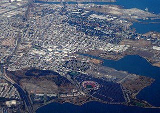
Oyster Point Marina/Park is a 408-berth public marina and 33-acre (13 ha) park located in the city of South San Francisco, California on the western shoreline of San Francisco Bay.

<span class="mw-page-title-main">San Rafael Bay</span> Bay in California, United States

San Rafael Bay is an embayment of San Pablo Bay, located in Marin County and the northern San Francisco Bay Area, California.

<span class="mw-page-title-main">Marina District, San Francisco</span> Neighborhood of San Francisco in California, United States

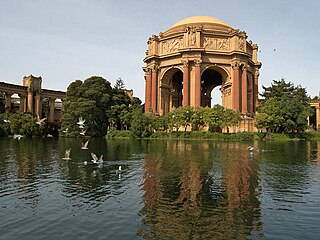
The Marina District is a neighborhood located in San Francisco, California. The neighborhood sits on the site of the 1915 Panama–Pacific International Exposition, staged after the 1906 San Francisco earthquake to celebrate the reemergence of the city. Aside from the Palace of Fine Arts, all other buildings were demolished to make the current neighborhood.

<span class="mw-page-title-main">Albany Bulb</span> Former landfill in Albany, California

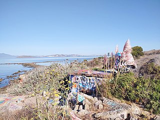
The Albany Bulb is a former landfill largely owned by the City of Albany, in California. The Bulb is the west end of a landfill peninsula jutting west from the east shore of San Francisco Bay. The term "Bulb" is often used to refer to the entire peninsula, which includes the Albany Plateau, north of Buchanan Street at its base; the high narrow "Neck," and the round "Bulb." The Bulb is part of the City of Albany, and can be reached via Buchanan Street or the Bay Trail along the east side of San Francisco Bay. Landmarks include, Mary's Mask, Gritchell's Bay, and Mad Marc's Castle. The Geotag for Gritchell's Bay is 37.8908083, -122.3257826.

Hispanic and Latino Americans in San Francisco form 15.1% of the population. The city's population includes 121,744 Hispanics or Latinos of any race. The principal Hispanic groups in the city were those of Mexican (7.4%), Salvadoran (2.0%), Nicaraguan (0.9%), Guatemalan (0.8%), and Puerto Rican (0.5%) ancestry. The Hispanic population is most heavily concentrated in the Mission District, Tenderloin District, and Excelsior District.

<span class="mw-page-title-main">Aramburu Island</span> Island in California

Aramburu Island is a 17-acre (6.9 ha) island in Richardson Bay, Marin County, California. It, along with Strawberry Spit, came to exist in the 1950s and 1960s as a consequence of dumping dredged material from nearby developments into the bay. In the 1980s, the northern part of the landmass was cut off from Strawberry Spit on the directions of a Marin County supervisor to prevent housing from being constructed there, creating Aramburu Island. While natural erosion processes caused it to shrink slowly over the course of subsequent decades, a 2010s restoration effort added large amounts of material to prevent further erosion, and turned it into "sustainable bird habitat".

References

  1. San Rafael 2020, Neighborhoods Archived 2011-06-08 at the Wayback Machine Neighborhood Element of the San Rafael General Plan, pp. 88-97, Accessed 2006-12-29
  2. 1 2 Neilson, Susie (2021-10-08). "This neighborhood in Marin is the most segregated in the Bay Area". San Francisco Chronicle. Retrieved 2023-11-17.
  3. 1 2 3 Marin, Healthy. "Healthy Marin :: Stories :: Marin County City Profiles". www.healthymarin.org. Retrieved 2023-12-13.
  4. 1 2 3 "Nearly 80% of Marin County COVID-19 cases are Latino, largest racial disparity in Bay Area". ABC7 San Francisco. 2020-07-23. Retrieved 2023-12-13.
  5. Central Marin Sanitation Agency official site accessed December 30, 2006
  6. Golden Gate Transit official site accessed December 30, 2006

37°57′45″N122°30′7″W / 37.96250°N 122.50194°W / 37.96250; -122.50194