The Cullasaja River is a short river located entirely in Macon County, North Carolina. It is a tributary of the Little Tennessee River, into which it flows near the county seat of Franklin. It originates to the southeast, near Highlands, the county's only other town. It flows from manmade Lake Sequoyah, which is fed by Mirror Lake and other creeks and streams originating on the western side of the Eastern Continental Divide, which runs through the east side of Highlands.

Buttermilk Falls State Park is a 811-acre (3.28 km2) state park located southwest of Ithaca, New York, United States. Like Robert H. Treman State Park, a portion of the land that was to become the state park came from Robert and Laura Treman in 1924.
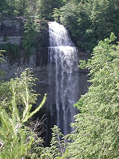
The Falling Water River is a 46.8-mile-long (75.3 km) stream in the east-central portion of Middle Tennessee in the United States. It rises just west of Monterey at the edge of the Cumberland Plateau, and traverses the Eastern Highland Rim before dropping off to the Nashville Basin and emptying into Center Hill Lake along the Caney Fork. The river is noted for the 136-foot (41 m) Burgess Falls, which it spills over near the end of its course.

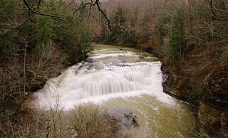
The Caney Fork River is a river that flows through central Tennessee in the United States, draining a substantial portion of the southwestern Cumberland Plateau and southeastern Highland Rim regions. It is a major tributary of the Cumberland River, and is part of the Cumberland, Ohio and Mississippi basins. The river is 143 miles (230 km) long, and its watershed covers 1,771 square miles (4,590 km2) in eleven counties. Monterey, Baxter, Sparta, Smithville, McMinnville, Altamont, Spencer and Gordonsville are among the towns that are at least partially drained by the river.
Burgess Falls State Park is a state park and state natural area in Putnam County and White County, Tennessee, located in the southeastern United States. The park is situated around a steep gorge in which the Falling Water River drops 250 feet (76 m) in elevation in less than a mile, culminating in a 136-foot (41 m) cataract waterfall.

Rock Island State Park is a state park in Warren County and White County, Tennessee, located in the Southeastern United States. The park is named after the community of Rock Island, Tennessee, which in turn received its name from an island on the Caney Fork upstream from the Collins River confluence and Great Falls Dam. Rock Island State Park is centered on a peninsula created by the confluence of these two rivers and extends downstream to the headwaters of Center Hill Lake.
Anna Ruby Falls is located near Unicoi State Park in White County near Helen, Georgia. The waterfall is accessible via a half mile paved trail from a public use area with a small admittance charge. The Anna Ruby Falls Trail is designated a National Recreation Trail in Georgia.

The Stoney Creek Falls is a cascade waterfall on the Stoney Creek located where the river descends from the Atherton Tablelands to the Cairns coastal plain, in Queensland, Australia.
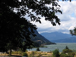
Starvation Creek State Park is a state park located west of Hood River, Oregon in the Columbia River Gorge. It was named Starvation Creek because a train was stopped there by snow drifts and passengers had to dig out the train. No one starved there.

Crabtree Falls is one of the tallest sets of waterfalls in the United States east of the Mississippi River. It is located in the George Washington National Forest in Nelson County, Virginia, off of Virginia State Route 56. The name of the falls is thought to have come from William Crabtree, who settled in this part of Virginia in 1777. L.A. Snead, former US Assistant Fuel Administrator (WWI), environmentalist and notable Nelsonian, spearheaded negotiations to secure land surrounding Crabtree Falls after it was almost developed as a resort area in the late 1960s. Using personal and Congressional funds, the land deals were completed and the deeds transferred by LA Snead on June 3, 1968, to the National Forest System. This assured benefit for future generations of this magnificent Nelson County treasure.

The Wagner Falls Scenic Site is a Michigan State Park, located in central Alger County, Upper Michigan. The 23-acre (0.1 km²) state scenic area protects Wagner Falls.

Scott's Gulf is a canyon situated along the Caney Fork in White County, Tennessee, in the southeastern United States. The canyon stretches for approximately 18 miles (29 km) as the Caney Fork drops from the top of the Cumberland Plateau down to the eastern Highland Rim. This remote section of the river is home to a wilderness area consisting of a largely undisturbed deciduous forest, numerous waterfalls, caves and other geological formations, and Class IV and Class V whitewater rapids.

The Surprise Creek Falls, a segmented waterfall on the Surprise Creek, is located in the UNESCO World Heritage–listed Wet Tropics in the Far North region of Queensland, Australia.

Tip Toe Falls, is a 6-foot (1.8 m) tall waterfall on Fall Creek in the Portola Redwoods State Park, California. There is also a 8-foot (2.4 m) upper falls, a few hundred feet upstream, which is much lesser known.

Crabtree Falls is a waterfall located near the boundary of McDowell County and Yancey County, North Carolina.

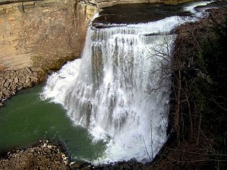
Rockhouse Falls, is a 125 feet (38 m) plunge waterfall that marks Rockhouse Creek's confluence with Cane Creek. The waterfall, which shares a plungepool with Cane Creek Falls, is visible from the Gorge Trail and from the base of the Cane Creek Gorge. The falls are located near Spencer, Tennessee in Fall Creek Falls State Park.

Piney Creek Falls is a 95 feet (29 m) waterfall located along Piney Creek, a mile or so above its confluence with Cane Creek. A trail leads an overlook above the falls. There is no trail to the base of the falls which can only be accessed by rappel or a rugged hike up the Piney Creek Gorge. The falls are located near Spencer, Tennessee in Fall Creek Falls State Park.

Cascade Falls Regional Park is a regional park under the administration of the Fraser Valley Regional District in the Lower Mainland region of British Columbia, Canada. The park was originally 9.5 hectares in area but was expanded to a current 22 hectares. It has picnic tables and pit toilets, with various hiking trails and a walkway leading to a viewing platform over a large waterfall 30m in vertical drop, which is 15 minutes from the park's parking lot. It is located in the McConnell Creek area northeast of Mission, which gets its name from the former name of Cascade Creek, McConnell Creek, which was named for a logger in the area called Jack McConnell. Cascade Creek's outfall is into the southeast end of Stave Lake near Davis Lake Provincial Park.