Cannon Field

Last updated
Cannon Field
Summary
Airport type Public use
Owner/Operator Alamo Liaison Group (dba Alamo Liaison Squadron)
Serves Somerset, Texas
Elevation  AMSL 610 ft / 186 m
Coordinates 29°12′58″N098°32′58″W / 29.21611°N 98.54944°W / 29.21611; -98.54944 Coordinates: 29°12′58″N098°32′58″W / 29.21611°N 98.54944°W / 29.21611; -98.54944
Map
USA Texas location map.svg
Airplane silhouette.svg
53T
Location of airport in Texas
Runways
Direction Length Surface
ft m
16/34 2,880 878 Turf
Statistics (2011)
Aircraft operations 600
Based aircraft 13

Cannon Field( FAA LID : 53T, formerly 53TX) is a privately owned, public use airport located six  nautical miles (7  mi, 11  km) east of the central business district of Somerset, a city in Bexar County, Texas, United States. [1] It is a small airport on the south side of San Antonio, located at the southwest corner of the intersection of Loop 1604 and Applewhite Road.

Federal Aviation Administration United States Government agency dedicated to civil aviation matters

The Federal Aviation Administration (FAA) is a governmental body of the United States with powers to regulate all aspects of civil aviation in that nation as well as over its surrounding international waters. Its powers include the construction and operation of airports, air traffic management, the certification of personnel and aircraft, and the protection of U.S. assets during the launch or re-entry of commercial space vehicles. Powers over neighboring international waters were delegated to the FAA by authority of the International Civil Aviation Organization.

A location identifier is a symbolic representation for the name and the location of an airport, navigation aid, or weather station, and is used for manned air traffic control facilities in air traffic control, telecommunications, computer programming, weather reports, and related services.

Airport location where aircraft take off and land

An airport is an aerodrome with extended facilities, mostly for commercial air transport. Airports often have facilities to store and maintain aircraft, and a control tower. An airport consists of a landing area, which comprises an aerially accessible open space including at least one operationally active surface such as a runway for a plane to take off or a helipad, and often includes adjacent utility buildings such as control towers, hangars and terminals. Larger airports may have airport aprons, taxiway bridges, air traffic control centres, passenger facilities such as restaurants and lounges, and emergency services. In some countries, the US in particular, they also typically have one or more fixed-base operators, serving general aviation.

Contents

History

Cannon Field is the home of the Alamo Liaison Squadron. The squadron primarily restores, maintains, and flies World War II liaison aircraft from their home base on the field. The squadron hosts an annual picnic and welcomes visitors.

World War II 1939–1945 global war

World War II, also known as the Second World War, was a global war that lasted from 1939 to 1945. The vast majority of the world's countries—including all the great powers—eventually formed two opposing military alliances: the Allies and the Axis. A state of total war emerged, directly involving more than 100 million people from over 30 countries. The major participants threw their entire economic, industrial, and scientific capabilities behind the war effort, blurring the distinction between civilian and military resources. World War II was the deadliest conflict in human history, marked by 50 to 85 million fatalities, most of whom were civilians in the Soviet Union and China. It included massacres, the genocide of the Holocaust, strategic bombing, premeditated death from starvation and disease, and the only use of nuclear weapons in war.

Liaison aircraft Light aircraft for artillery observation and military communications

A liaison aircraft is a small, usually unarmed aircraft primarily used by military forces for artillery observation or transporting commanders and messages. The concept developed before World War II and included also battlefield reconnaissance, air ambulance, column control, light cargo delivery and similar duties. Able to operate from small, unimproved fields under primitive conditions, with STOL capabilities, most liaison aircraft were developed from, or were later used as general aviation aircraft. Both fixed-wing aircraft and helicopters can perform liaison duties.

Facilities and aircraft

Cannon Field covers an area of 33 acres (13 ha) at an elevation of 610 feet (186 m) above mean sea level. It has one runway designated 16/34 with a turf surface measuring 2,880 by 100 feet (878 x 30 m). [1]

Acre unit of area

The acre is a unit of land area used in the imperial and US customary systems. It is traditionally defined as the area of one chain by one furlong, which is exactly equal to 10 square chains, ​1640 of a square mile, or 43,560 square feet, and approximately 4,047 m2, or about 40% of a hectare. Based upon the International yard and pound agreement of 1959, an acre may be declared as exactly 4,046.8564224 square metres. The acre is a statute measure in the United States and was formerly one in the United Kingdom and almost all countries of the former British Empire, although informal use continues.

Hectare metric unit of area

The hectare is an SI accepted metric system unit of area equal to a square with 100-metre sides, or 10,000 m2, and is primarily used in the measurement of land. There are 100 hectares in one square kilometre. An acre is about 0.405 hectare and one hectare contains about 2.47 acres.

Elevation Height of a geographic location above a fixed reference point

The elevation of a geographic location is its height above or below a fixed reference point, most commonly a reference geoid, a mathematical model of the Earth's sea level as an equipotential gravitational surface . The term elevation is mainly used when referring to points on the Earth's surface, while altitude or geopotential height is used for points above the surface, such as an aircraft in flight or a spacecraft in orbit, and depth is used for points below the surface.

For the 12-month period ending March 26, 2011, the airport had 600 general aviation aircraft operations, an average of 50 per month. At that time there were 13 aircraft based at this airport, all single-engine. [1]

General aviation civil use of aircraft excluding commercial transportation

General Aviation (GA) represents the 'private transport' and recreational flying component of aviation.

Aircraft engine Engine designed for use in powered aircraft

An aircraft engine is a component of the propulsion system for an aircraft that generates mechanical power. Aircraft engines are almost always either lightweight piston engines or gas turbines, except for small multicopter UAVs which are almost always electric aircraft.

Related Research Articles

Martin State Airport joint civil-military public use airport in Baltimore County, Maryland, United States

Martin State Airport is a joint civil-military public use airport located nine nautical miles east of the central business district of Baltimore, in Baltimore County, Maryland, United States. The facility is located within the census-designated place of Middle River on Maryland State Highway 150, near the intersection of Maryland State Highway 700. The Maryland Aviation Administration operates the Airport on behalf of the Maryland Department of Transportation. MTN is a general aviation relief airport.

Lincoln Airport (Nebraska) public airport and military airbase serving Lincoln, Nebraska, USA

Lincoln Airport is a public/military airport five miles northwest of downtown Lincoln, the state capital, in Lancaster County, Nebraska. It is owned by the Lincoln Airport Authority and is the second-largest airport in Nebraska.

William R. Fairchild International Airport

William R. Fairchild International Airport, not to be confused with Fairchild Air Force Base, is a public airport located within the city limits of Port Angeles, in Clallam County, Washington, United States. It lies 3.5 miles northwest of the central business district of Port Angeles, near the Strait of Juan de Fuca. The airport is owned by the Port of Port Angeles.

North Palm Beach County General Aviation Airport

North Palm Beach County Airport, also known as North County Airport, is an uncontrolled general aviation airport located 12 nautical miles (22 km) northwest of West Palm Beach off the Bee Line Highway in Palm Beach Gardens, Florida. The airport is owned by Palm Beach County and operated by the Palm Beach County Airports Department.

Rostraver Airport

Rostraver Airport is a public use airport in Westmoreland County, Pennsylvania, United States. It is located five nautical miles east of the central business district of Monongahela, Pennsylvania in Rostraver Township. It is operated by the Westmoreland County Airport Authority, which also operates the Arnold Palmer Regional Airport in Unity Township, Pennsylvania.

Atlanta Regional Airport

Atlanta Regional Airport, also known as Falcon Field, is a public use airport in Fayette County, Georgia, United States. It is located 25 nautical miles southwest of the central business district of Atlanta, in Peachtree City. This airport is included in the National Plan of Integrated Airport Systems for 2017–2021, which categorized it as a regional general aviation facility.

Anoka County–Blaine Airport airport in Minnesota, United States

Anoka County–Blaine Airport, also known as Janes Field, is a public use airport in Anoka County, Minnesota, United States. Owned by Metropolitan Airports Commission, it is 10 nautical miles (19 km) north of the central business district of Minneapolis. The airport is located in the city of Blaine.

Mulino State Airport airport in Oregon, United States

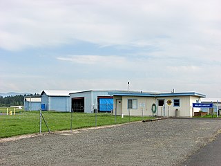
Mulino State Airport is a public airport located at Mulino, Oregon, near the city of Molalla, about 20 nautical miles south of Portland with access from Interstate 205 via Oregon Route 213. Also known as Mulino Airport, it was owned by the Port of Portland from 1988 until it was transferred to the Oregon Department of Aviation on July 1, 2009. It was previously also known as Portland-Mulino Airport.

York Airport (Pennsylvania)

York Airport is a privately owned, public use airport located seven nautical miles southwest of the central business district of York, a city in York County, Pennsylvania, United States. This airport, owned and operated by York Aviation, was included in the National Plan of Integrated Airport Systems for 2009–2013, which categorized it as a general aviation facility.

Danielson Airport

Danielson Airport is a state owned, public use airport located two nautical miles (4 km) northwest of the central business district of Danielson, a borough in the town of Killingly in Windham County, Connecticut, United States. The smallest airport in the state, it is included in the Federal Aviation Administration (FAA) National Plan of Integrated Airport Systems for 2017–2021, in which it is categorized as a local general aviation facility.

Robertson Field (Connecticut)

Robertson Field, also known as Robertson Airport, is a public use airport in Hartford County, Connecticut, United States. It is owned by the town of Plainville and located two nautical miles (4 km) north of its central business district. It is included in the Federal Aviation Administration (FAA) National Plan of Integrated Airport Systems for 2017–2021, in which it is categorized as a local reliever airport facility.

W. K. Kellogg Airport

W. K. Kellogg Airport is a city-owned, public-use, joint civil-military airport located three nautical miles (6 km) west of the central business district of Battle Creek, a city in Calhoun County, Michigan, United States. The airport is accessible by road from Helmer Road, and is located near I-94. It is included in the Federal Aviation Administration (FAA) National Plan of Integrated Airport Systems for 2017–2021, in which it is categorized as a regional general aviation facility. It is also known as W. K. Kellogg Regional Airport.

London-Corbin Airport, also known as Magee Field, is a general aviation airport located in Laurel County, Kentucky, three nautical miles south of the central business district of London and about 12 miles north of Corbin. The airport is operated by both cities. It is not currently served by scheduled airline service, though service was once available on US Airways Express dba Air Kentucky and Tennessee Airways. Prior to the passage of the Airline Deregulation Act, the airport was served by Piedmont Airlines (1948-1989) turboprops, including the Fairchild Hiller FH-227 and the NAMC YS-11.

Ormond Beach Municipal Airport

Ormond Beach Airport, also known as Ormond Beach Municipal Airport, is a general aviation airport located 3 miles (4.8 km) to the northwest of the city of Ormond Beach in Volusia County, Florida, USA.

Cecil Airport is a public joint civil-military airport and spaceport located in Jacksonville, Florida. The airport is owned by the Jacksonville Aviation Authority and services military aircraft, corporate aircraft, general aviation, and air cargo. The Florida Army National Guard's primary Army Aviation Support Facility and the U.S. Coast Guard's Helicopter Interdiction Tactical Squadron (HITRON) are also located here, the former operating CH-47 Chinook, UH-60 Blackhawk, UH-72 Lakota and C-12 Huron aircraft, while the latter operates the MH-65C Dolphin helicopter.

Moton Field Municipal Airport

Moton Field Municipal Airport is a public-use airport located three nautical miles north of the central business district of Tuskegee, a city in Macon County, Alabama, United States. The airport is owned by the City of Tuskegee. It is included in the FAA's National Plan of Integrated Airport Systems for 2011–2015, which categorized it as a general aviation facility.

Statesboro–Bulloch County Airport

Statesboro–Bulloch County Airport is a public airport located three miles (5 km) northeast of the central business district of Statesboro, a city in Bulloch County, Georgia, United States. It is owned by the City of Statesboro and Bulloch County. Currently, there is no commercial service to the airport.

Grove Hill Municipal Airport

Grove Hill Municipal Airport is a city-owned public-use airport located two nautical miles southeast of the central business district of Grove Hill, a city in Clarke County, Alabama, United States. According to the FAA's National Plan of Integrated Airport Systems for 2009–2013, it is categorized as a general aviation facility.

Miami Homestead General Aviation Airport is a county-owned public-use airport in unincorporated Miami-Dade County, Florida, United States, located four nautical miles (7 km) northwest of the central business district of Homestead.

Mitchell Municipal Airport

Mitchell Municipal Airport is a city-owned, public-use airport located three nautical miles (6 km) north of the central business district of Mitchell, a city in Davison County, South Dakota, United States. It is included in the National Plan of Integrated Airport Systems for 2011–2015, which categorized it as a general aviation airport.

References

  1. 1 2 3 4 FAA Airport Master Record for 53T ( Form 5010 PDF ). Federal Aviation Administration. Effective April 5, 2012.
The National Map

The National Map is a collaborative effort of the United States Geological Survey (USGS) and other federal, state, and local agencies to improve and deliver topographic information for the United States. The purpose of the effort is to provide "...a seamless, continuously maintained set of public domain geographic base information that will serve as a foundation for integrating, sharing, and using other data easily and consistently".