Paynesville is a city in Stearns County, Minnesota, United States, on Lake Koronis, in the central part of the state. The population was 2,388 at the 2020 census. It is part of the St. Cloud Metropolitan Statistical Area.

The Cannon River a tributary of the Mississippi River flows 112 miles (180 km) from Shields Lake near Shieldsville to Red Wing in the U.S. state of Minnesota, where it joins the Mississippi River. It drains a watershed approximately 1460 square miles (3,780 km²) in size. The river flows through the counties of Le Sueur, Rice, Dakota, and Goodhue.

The Saint Louis River is a river in the U.S. states of Minnesota and Wisconsin that flows into Lake Superior. The largest U.S. river to flow into the lake, it is 192 miles (309 km) in length and starts 13 miles (21 km) east of Hoyt Lakes, Minnesota. The river's watershed covers 3,634 square miles (9,410 km2). Near the Twin Ports of Duluth, Minnesota and Superior, Wisconsin, the river becomes a freshwater estuary.

Leech Lake is a lake located in north central Minnesota, United States. It is southeast of Bemidji, located mainly within the Leech Lake Indian Reservation, and completely within the Chippewa National Forest. It is used as a reservoir. The lake is the third largest in Minnesota, covering 102,947.83 acres (416.6151 km2) with 195 miles (314 km) of shoreline and has a maximum depth of 156 feet (48 m).

Bde Maka Ska is the largest lake in Minneapolis, Minnesota, United States, and part of the city's Chain of Lakes. Surrounded by city park land and circled by bike and walking trails, it is popular for many outdoor activities. The lake has an area of 401 acres (1.62 km2) and a maximum depth of 87 feet (27 m).
Okamanpeedan Lake, partially located in Martin County, Minnesota, and Emmet County, Iowa, is also known as Tuttle Lake. Okamanpeedan Lake is a roughly 2,300-acre (9.3 km2) riverine lake located on the East Fork of the Des Moines River. It has an average depth of about four to six feet. The lake has a contributing watershed of approximately 120,056 acres (486 km2) and watershed:lake ratio on the order of about 50:1. The lake is situated in a glacial till plain and is generally in an area dominated by loamy, poorly drained soils. The area is primarily level but does have some rolling hills.

Lake Vermilion is a shallow freshwater lake in northeastern Minnesota, United States. The Ojibwe originally called the lake Onamanii-zaaga'iganiing, which means “the evening sun tinting the water a reddish color”. French fur traders translated this to the Latin word Vermilion, which is a red pigment. Lake Vermilion is located between the towns of Tower on the east and Cook on the west, in the heart of Minnesota's Arrowhead Region at Vermilion Iron Range. The area was mined from the late 19th century until the 1960s, and the Soudan Mine operated just south of the lake.

Lake Hiawatha is located just north of Lake Nokomis in Minneapolis, Minnesota. It was purchased by the Minneapolis Park and Recreation Board in 1922 for $550,000. At that time the lake was a marsh known as Rice Lake, but over four years, the park system transformed the wetland into a lake surrounded by a park.
Bachelor Lake is a lake in Brown County, Minnesota in the northeastern part of Stark township. Covering 79.80 acres, it is an officially protected water of the State of Minnesota. The lake is within the Cottonwood River Major Watershed. The lake’s elevation is 1,004 feet (306 m), and it is zoned as a shoreland area which is regulated as a shoreland management water.

Glacial Lakes State Park is a state park of Minnesota, USA, approximately 5 miles (8.0 km) south of Starbuck. It was founded in 1963 to preserve some of the remaining rolling prairie which previously covered much of the state. Located in the Leaf Mountains, the park and the area around it contains many glacial landforms created by the Wisconsonian glaciation.

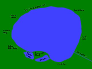
Lake George is a small lake in Anoka County, Minnesota, located within the city of Oak Grove, 12 miles (19 km) north of the city of Anoka. Minnesota's Department of Natural Resources tracks the lake by the name George and the identifier 02-0091-00. The USGS tracks the lake by the ID 644081 and the coordinates of 45°21′25″N93°20′10″W

The Minnesota Department of Natural Resources, or Minnesota DNR, is the agency of the U.S. state of Minnesota charged with conserving and managing the state's natural resources. The agency maintains areas such as state parks, state forests, recreational trails, and recreation areas as well as managing minerals, wildlife, and forestry throughout the state. The agency is divided into six divisions - Ecological & Water Resources, Enforcement, Fish & Wildlife, Forestry, Lands & Minerals, and Parks & Trails.

The natural history of Minnesota covers the plant and animal species of the U.S. state of Minnesota. The continental climate and location of Minnesota at the physiographic intersection of the Laurentian and the Interior Plains influences its plant and animal life. Three of North America's biomes converge in Minnesota: prairie grasslands in the southwestern and western parts of the state, the eastern temperate deciduous forests in the east-central and the southeast, and the coniferous forest in the north-central and northeast.

Crescent Lake is a lake located in Tofte Township and Lutsen Township, Cook County, Minnesota.

Greenleaf Lake State Recreation Area is a state park unit of Minnesota, USA, currently in development. It includes undeveloped shoreline on both Greenleaf and Sioux Lakes, halfway between the cities of Hutchinson and Litchfield in Meeker County. Portions of the state recreation area (SRA) are open to the public for day-use recreation, but there are no facilities yet on site. The park boundaries were set by the Minnesota Legislature and the state is still acquiring land from willing sellers; two-thirds of the property remain privately owned.

The Turtle-Flambeau Flowage is a 12,942 acres (52.37 km2) lake in Iron County, Wisconsin. It has a maximum depth of 15 meters and is the seventh largest lake in the state of Wisconsin by surface area. The flowage is home to unique wetland patterns and plant species as well as several species of sport and game fish, including musky, panfish, largemouth bass, smallmouth bass, northern pike, walleye and sturgeon. The lake's water clarity is low, but can vary in different locations. Fishing, camping, boating, and hunting are popular activities on the flowage, and Ojibwe people traditionally harvest fish and game on the lake. Environmental concerns on the flowage include mercury contamination, algal blooms, and several types of invasive species.

Amelia Lake is a lake in Pope County, Minnesota, the United States, located 6.7 miles away from Glenwood. Amelia lake has an elevation of around 1,348 feet (411 m). The lake sits on a lot of 910 acres. The depth of Amelia Lake is 69 feet (21 m) and water clarity can approach 12 feet (3.7 m) during the summer. This lake is open to the public to fish with a proper fishing license.

Lake Byllesby is a 1,432-acre artificial lake on the Cannon River in Dakota and Goodhue counties, in the U.S. State of Minnesota. The lake was formed as a result of construction of the Byllesby Dam by the H.M. Byllesby & Company, which would later become Northern States Power Company for hydroelectric power generation. Today, the lake serves as a popular recreational destination and is the largest lake in Southern Dakota County, approximately 30 miles (48 km) southeast of the Twin Cities.


