The Kingdom of Asturias was a kingdom in the Iberian Peninsula founded by the Visigothic nobleman Pelagius. It was the first Christian political entity established after the Umayyad conquest of Visigothic Hispania in 711. In the Summer of 722, Pelagius defeated an Umayyad army at the Battle of Covadonga, in what is retroactively regarded as the beginning of the Reconquista.

Cantabria is an autonomous community and province in northern Spain with Santander as its capital city. It is called a comunidad histórica, a historic community, in its current Statute of Autonomy. It is bordered on the east by the Basque autonomous community, on the south by Castile and León, on the west by the Principality of Asturias, and on the north by the Cantabrian Sea, which forms part of the Bay of Biscay.

A Foehn, or Föhn, is a type of dry, relatively warm downslope wind that occurs in the lee of a mountain range. It is a rain shadow wind that results from the subsequent adiabatic warming of air that has dropped most of its moisture on windward slopes. As a consequence of the different adiabatic lapse rates of moist and dry air, the air on the leeward slopes becomes warmer than equivalent elevations on the windward slopes.

The Picos de Europa are a mountain range extending for about 20 km (12 mi), forming part of the Cantabrian Mountains in northern Spain. The range is situated in the Autonomous Communities of Asturias, Cantabria and Castile and León. The highest peak is Torre de Cerredo, at an elevation of 2650 m (8,690 ft).

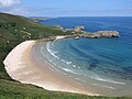
The Mar Cantábrico or Cantabrian Sea is the term used mostly in Spain to describe the coastal sea of the Atlantic Ocean that borders the northern coast of Spain and the southwest side of the Atlantic coast of France, included in the Bay of Biscay. It extends from the cape Estaca de Bares in the province of A Coruña, to the mouth of the river Adour, near the city of Bayonne on the coast of the department of Pyrénées-Atlantiques in French Basque Country. The Cantabrian Sea contains the Avilés Canyons System.

The Cantabri or Ancient Cantabrians were a pre-Roman people and large tribal federation that lived in the northern coastal region of ancient Iberia in the second half of the first millennium BC. These peoples and their territories were incorporated into the Roman Province of Hispania Tarraconensis in 19 BC, following the Cantabrian Wars.
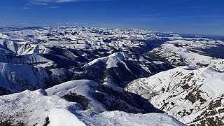
The Cantabrian Mountains or Cantabrian Range are one of the main systems of mountain ranges in Spain. They stretch for over 300 km (180 miles) across northern Spain, from the western limit of the Pyrenees to the Galician Massif in Galicia, along the coast of the Cantabrian Sea. Their easternmost end meets the Sistema Ibérico.
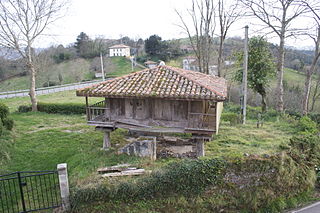
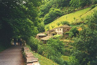
An hórreo is a typical granary from the northwest of the Iberian Peninsula, built in wood or stone, raised from the ground by pillars ending in flat staddle stones to prevent access by rodents. Ventilation is allowed by the slits in its walls.
The Franco-Cantabrian region is a term applied in archaeology and history to refer to an area that stretches from Asturias, in northern Spain, to Aquitaine and Provence in Southern France. It includes the southern half of France and the northern strip of Spain looking at the Bay of Biscay.

The Basque Mountains are a mountain range situated in the northern Iberian Peninsula. Geographically the range is considered as the eastern section of the larger Cantabrian Range. The range runs through the Basque Autonomous Community and western Navarre.

The Cantabria autonomous football team is the regional football team for Cantabria, Spain. They are not affiliated with FIFA or UEFA and therefore are only allowed to play friendly matches.

The Picos de Europa National Park is a National Park in the Picos de Europa mountain range, in northern Spain. It is within the boundaries of three autonomous communities, Asturias, Cantabria and Castile and León, which are represented on the body which runs the park. The park is also a popular destination for hikers and trekkers.

San Glorio is a mountain pass in the Cantabrian Mountains of Northern Spain. The pass reaches an elevation of 1610 meters along the national highway N621 which connects the city of León with Cantabria and which passes through Asturias. The pass is situated some 800m from the southern border of the Picos de Europa National Park, a park included in UNESCO's World Network of Biosphere Reserves and shared by the provinces of León, Asturias and Cantabria. The valleys of this part of the Cantabrian Mountains include sites in the European Union's Natura 2000 network and Special Protection Areas for the conservation of wild birds. San Glorio is used as a corridor by the Cantabrian brown bear Ursus arctos, catalogued in Spain as being in danger of extinction. Moreover, the slopes of the glacial valleys making up the surrounding region are home to an important variety of plant life.
The Turia Valley is a small valley on the western border of the Cantabrian Mountains in the northwest of Spain which is close to beaches and is divided by two autonomous communities: Asturias and Galicia. It consists of an area of 90 km2, 3,910 inhabitants and is 200 m above sea level. The two main towns are A Pontenova (Galicia) and Taramundi (Asturias).

The climate of Spain is highly diverse and varies considerably across the country's various regions. Spain is a very climatically diverse country, sometimes described as the most varied in Europe, and has 13 different Köppen climates.
Boroña is a type of bread made with corn in northern Spain. This cornbread is a bread made with cornmeal. It is a traditional food from the regions of Galicia, Asturias, Cantabria, the Basque Country and northern Castilla-Leon, Spain. It has been widely used in rural areas until the mid twentieth century. It is usually cooked in an oven wrapped in cabbage leaves.
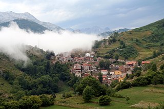
Tresviso is a municipality located in the autonomous community of Cantabria, Spain. The municipality is located 907 m (2,976 ft) above sea level within the Picos de Europa of the Cantabrian Mountains. The village is located on a mountain ledge approximately 800 m (2,600 ft) above the Deva River valley bottom. Despite being in Cantabria, the only road access to Tresviso is a narrow road over a 1,320 m (4,330 ft) high pass from Sotres in the neighbouring province of Asturias. Alternatively, on the Cantabrian side there is a strenuous 3-hour hike from the N621 highway along the Deva featuring many switchbacks.
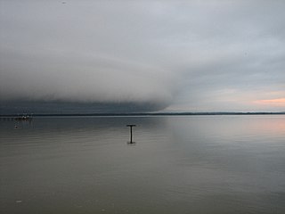
A galerna is a sudden and violent storm with strong wind gusts from the west or northwest that affects coastal areas of the Cantabrian Sea and the Bay of Biscay, predominantly from spring to fall. It especially affects the central and eastern part of the Spanish north coast provinces and the southwestern region of France. The name comes from French galerne and that originates from Breton (gwalarn), a wind from the northwest.

Vasco-Cantabria, in archaeology and the environmental sciences, is an area on the northern coast of Spain. It covers similar areas to the northern parts of the adjacent modern regions of the Basque country and Cantabria. In geology the "Vasco-Cantabrian Basin" or "Basque-Cantabrian Basin" covers the area and the seas off the coast in the Bay of Biscay, an area between the Iberian and European tectonic plates.

The Cantabrian mixed forests is a temperate broadleaf and mixed forests ecoregion in southwestern Europe. It extends along the coastal Cantabrian Mountains and Galician Massif of Northern Spain, extending south into northern Portugal, and northwards through the westernmost Pyrenees to southwestern France. The ecoregion extends from the seacoast to the highest peaks of the Cantabrian Mountains. The highest peak is Torre Cerredo at 2,648 meters elevation.