The following is a list of the 17 cantons of the Lot department, in France, following the French canton reorganisation which came into effect in March 2015:
The arrondissement of Cahors is an arrondissement of France in the Lot department in the Occitanie région. Since the January 2017 reorganization of the arrondissements of Lot, it has 98 communes.

The canton of Gramat is a canton in France. Since the French canton reorganisation which came into effect in March 2015, the communes of the canton of Gramat are:
The Roman Catholic Diocese of Cahors is a diocese of the Latin Rite of the Roman Catholic Church in France. The diocese comprises the whole of the department of Lot.
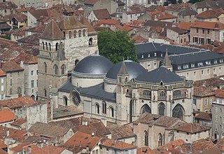
The canton of Cahors-1 is an administrative division of the Lot department, southern France. It was created at the French canton reorganisation which came into effect in March 2015. Its seat is in Cahors.
The canton of Cahors-1 is an administrative division of the Lot department, southern France. It was created at the French canton reorganisation which came into effect in March 2015. Its seat is in Cahors.
The canton of Causse et Vallées is an administrative division of the Lot department, southern France. It was created at the French canton reorganisation which came into effect in March 2015. Its seat is in Cajarc.
The canton of Puy-l'Évêque is an administrative division of the Lot department, southern France. Its borders were modified at the French canton reorganisation which came into effect in March 2015. Its seat is in Puy-l'Évêque.
The canton of Saint-Céré is an administrative division of the Lot department, southern France. Its borders were modified at the French canton reorganisation which came into effect in March 2015. Its seat is in Saint-Céré.
The canton of Agen-1 is an administrative division of the Lot-et-Garonne department, southwestern France. It was created at the French canton reorganisation which came into effect in March 2015. Its seat is in Agen.
The canton of Agen-4 is an administrative division of the Lot-et-Garonne department, southwestern France. It was created at the French canton reorganisation which came into effect in March 2015. Its seat is in Agen.
The canton of Le Confluent is an administrative division of the Lot-et-Garonne department, southwestern France. It was created at the French canton reorganisation which came into effect in March 2015. Its seat is in Aiguillon.
The canton of Les Coteaux de Guyenne is an administrative division of the Lot-et-Garonne department, southwestern France. It was created at the French canton reorganisation which came into effect in March 2015. Its seat is in Duras.
The canton of Le Livradais is an administrative division of the Lot-et-Garonne department, southwestern France. It was created at the French canton reorganisation which came into effect in March 2015. Its seat is in Sainte-Livrade-sur-Lot.
The canton of Le Pays de Serres is an administrative division of the Lot-et-Garonne department, southwestern France. It was created at the French canton reorganisation which came into effect in March 2015. Its seat is in Penne-d'Agenais.
The canton of Le Sud-Est agenais is an administrative division of the Lot-et-Garonne department, southwestern France. It was created at the French canton reorganisation which came into effect in March 2015. Its seat is in Layrac.
The canton of Tonneins is an administrative division of the Lot-et-Garonne department, southwestern France. Its borders were modified at the French canton reorganisation which came into effect in March 2015. Its seat is in Tonneins.
The canton of Le Val du Dropt is an administrative division of the Lot-et-Garonne department, southwestern France. It was created at the French canton reorganisation which came into effect in March 2015. Its seat is in Miramont-de-Guyenne.
The canton of Villeneuve-sur-Lot-1 is an administrative division of the Lot-et-Garonne department, southwestern France. It was created at the French canton reorganisation which came into effect in March 2015. Its seat is in Villeneuve-sur-Lot.

