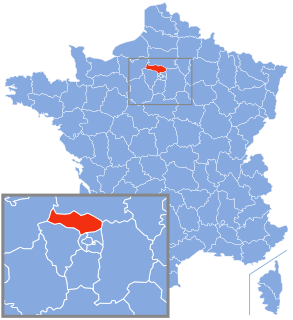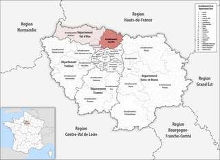
The arrondissement of Sarcelles is an arrondissement of France in the Val-d'Oise department in the Île-de-France region. Since the January 2017 reorganization of the arrondissements of Val-d'Oise, it has 62 communes.

The arrondissement of Les Andelys is an arrondissement of France in the Eure department in the Normandy region. It was expanded in 2006 with the two cantons of Louviers-Nord and Louviers-Sud from the arrondissement of Évreux. Since the January 2017 reorganization of the arrondissements of Eure, it has 187 communes.
The following is a list of the 25 cantons of the Val-de-Marne department, in France, following the French canton reorganisation which came into effect in March 2015:
The following is a list of the 21 cantons of the Val-d'Oise department, in France, following the French canton reorganisation which came into effect in March 2015:
Le Plessis is part of the name of 23 communes of France:
Transilien Paris-Nord is one of the sectors in the Paris Transilien suburban rail network. The trains on this sector depart from Gare du Nord in central Paris, as well as from Pontoise station in the suburbs. Transilien services from Paris – Nord are part of the SNCF Gare du Nord rail network. There are two groups of Transilien lines in the Nord sector, marked "H" and "K".

The Métropole du Grand Paris is an administrative structure for cooperation covering the City of Paris and its nearest suburbs that surround it. The métropole came into existence on January 1, 2016 and comprises 131 communes. It includes the City of Paris, all 123 communes in the surrounding inner-suburban departments of the Petite Couronne, plus seven communes in two of the outer-suburban departments, including the communes of Argenteuil in Val-d'Oise, and Paray-Vieille-Poste in Essonne, the latter of which covers part of Orly airport. Part of the métropole comprised the Seine department, which existed from 1929 to 1968. Grand Paris covers 814 square kilometers and has a population of 7 million.
The Communauté d'agglomération Roissy Pays de France is a communauté d'agglomération in the Val-d'Oise and Seine-et-Marne départements and in the Île-de-France région of France. It was formed on 1 January 2016 by the merger of the former communauté d'agglomération Val de France, communauté d'agglomération Roissy Porte de France and 17 communes that were part of the Communauté de communes Plaines et Monts de France. Its seat is in Roissy-en-France. Its population was 349,490 in 2014, of which 2,881 in Roissy-en-France and 57,455 in Sarcelles, the largest commune of the communauté d'agglomération.
The canton of Fontenay-sous-Bois is an administrative division of the Val-de-Marne department, Île-de-France region, northern France. It was created at the French canton reorganisation which came into effect in March 2015. Its seat is in Fontenay-sous-Bois.
The canton of Domont is an administrative division of the Val-d'Oise department, Île-de-France region, northern France. Its borders were modified at the French canton reorganisation which came into effect in March 2015. Its seat is in Domont.
The canton of Montmorency is an administrative division of the Val-d'Oise department, Île-de-France region, northern France. Its borders were modified at the French canton reorganisation which came into effect in March 2015. Its seat is in Montmorency.
The canton of Pontoise is an administrative division of the Val-d'Oise department, Île-de-France region, northern France. Its borders were modified at the French canton reorganisation which came into effect in March 2015. Its seat is in Pontoise.
The canton of Villiers-le-Bel is an administrative division of the Val-d'Oise department, Île-de-France region, northern France. Its borders were modified at the French canton reorganisation which came into effect in March 2015. Its seat is in Villiers-le-Bel.
The canton of Pacy-sur-Eure is an administrative division of the Eure department, northern France. Its borders were modified at the French canton reorganisation which came into effect in March 2015. Its seat is in Pacy-sur-Eure.
The canton of Compiègne-1 is an administrative division of the Oise department, northern France. It was created at the French canton reorganisation which came into effect in March 2015. Its seat is in Compiègne.
The canton of Nanteuil-le-Haudouin is an administrative division of the Oise department, northern France. Its borders were modified at the French canton reorganisation which came into effect in March 2015. Its seat is in Nanteuil-le-Haudouin.
The canton of Noyon is an administrative division of the Oise department, northern France. Its borders were modified at the French canton reorganisation which came into effect in March 2015. Its seat is in Noyon.
The canton of Saint-Just-en-Chaussée is an administrative division of the Oise department, northern France. Its borders were modified at the French canton reorganisation which came into effect in March 2015. Its seat is in Saint-Just-en-Chaussée.
The canton of Thourotte is an administrative division of the Oise department, northern France. It was created at the French canton reorganisation which came into effect in March 2015. Its seat is in Thourotte.