
The arrondissement of Bergerac is an arrondissement of France in the Dordogne department in the Nouvelle-Aquitaine region. Since the January 2017 reorganization of the arrondissements of Dordogne, it has 133 communes.

The arrondissement of Nontron is an arrondissement of France in the Dordogne department in the Nouvelle-Aquitaine region. Since the January 2017 reorganization of the arrondissements of Dordogne, it has 100 communes.
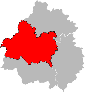
The arrondissement of Périgueux is an arrondissement of France in the Dordogne department in the Nouvelle Aquitaine region. Since the January 2017 reorganization of the arrondissements of Dordogne, it has 146 communes.

The arrondissement of Sarlat-la-Canéda is an arrondissement in France in the Dordogne department in the Nouvelle Aquitaine region. Since the January 2017 reorganization of the arrondissements of Dordogne, it has 141 communes.
Montignac, also called Montignac sur Vézère or Montignac-Lascaux, is a commune in the Dordogne department in Nouvelle-Aquitaine in southwestern France. It is a small town situated on the Vézère river and has been the capital of the canton of Montignac since 1790. In 2015 it became the capital of the newly created Canton de la Vallée de l'Homme. The poet Pierre Lachambeaudie (1806–1872) was born in the village.
The Canton of Brantôme is a canton of the Dordogne department, in France. The lowest point is 63 m, the highest point is at 251 m. At the French canton reorganisation which came into effect in March 2015, the canton of Brantôme was expanded from 11 to 42 communes :
The Canton of Nontron is a former canton of the Dordogne département, in France. It was disbanded following the French canton reorganisation which came into effect in March 2015. It consisted of 8 communes, which joined the canton of Périgord Vert Nontronnais in 2015.
The Canton of Thenon is a canton of the Dordogne département, in France. It was disbanded following the French canton reorganisation which came into effect in March 2015. The lowest point is 112 m in the commune of La Boissière-d'Ans, the highest point is in Azerat at 317 m, the average elevation is 209 m. The least populated commune is Gabillou with 89 inhabitants and the most populated commune is Thenon with 1,205 inhabitants.

Fanlac is a commune in the Dordogne department in Nouvelle-Aquitaine in southwestern France.
The Canton of Isle-Loue-Auvézère is a canton of the Dordogne département, in France. It was created at the French canton reorganisation, which came into effect in March 2015, from the former canton of Lanouaille and parts of the former cantons of Excideuil, Savignac-les-Églises, Thenon and Hautefort. Its seat is the town Excideuil.
The canton of Isle-Manoire is an administrative division of the Dordogne department, southwestern France. It was created at the French canton reorganisation which came into effect in March 2015. Its seat is in Boulazac-Isle-Manoire.
The canton of Lalinde is an administrative division of the Dordogne department, southwestern France. Its borders were modified at the French canton reorganisation which came into effect in March 2015. Its seat is in Lalinde.
The canton of Montpon-Ménestérol is an administrative division of the Dordogne department, southwestern France. Its borders were modified at the French canton reorganisation which came into effect in March 2015. Its seat is in Montpon-Ménestérol.
The canton of Périgord Central is an administrative division of the Dordogne department, southwestern France. It was created at the French canton reorganisation which came into effect in March 2015. Its seat is in Vergt.
The canton of Terrasson-Lavilledieu is an administrative division of the Dordogne department, southwestern France. Its borders were modified at the French canton reorganisation which came into effect in March 2015. Its seat is in Terrasson-Lavilledieu.
The canton of Thiviers is an administrative division of the Dordogne department, southwestern France. Its borders were modified at the French canton reorganisation which came into effect in March 2015. Its seat is in Thiviers.
The canton of Vallée Dordogne is an administrative division of the Dordogne department, southwestern France. It was created at the French canton reorganisation which came into effect in March 2015. Its seat is in Saint-Cyprien.
The canton of Périgord Vert Nontronnais is an administrative division of the Dordogne department, southwestern France. It was created at the French canton reorganisation which came into effect in March 2015. Its seat is in Nontron.
The canton of Sainte-Fortunade is an administrative division of the Corrèze department, south-central France. It was created at the French canton reorganisation which came into effect in March 2015. Its seat is in Sainte-Fortunade.

