The following is a list of the 25 cantons of the Dordogne department, in France, following the French canton reorganisation which came into effect in March 2015:
The arrondissement of Angoulême is an arrondissement of France in the Charente department in the Nouvelle-Aquitaine region. On 1 January 2008 the four cantons of Aigre, Mansle, Ruffec and Villefagnan that previously belonged to the arrondissement of Angoulême were added to the arrondissement of Confolens, and the canton of Rouillac to the arrondissement of Cognac. Since the January 2017 reorganization of the arrondissements of Charente, it has 117 communes.

The arrondissement of Nontron is an arrondissement of France in the Dordogne department in the Nouvelle-Aquitaine region. Since the January 2017 reorganization of the arrondissements of Dordogne, it has 100 communes.
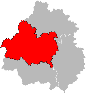
The arrondissement of Périgueux is an arrondissement of France in the Dordogne department in the Nouvelle Aquitaine region. Since the January 2017 reorganization of the arrondissements of Dordogne, it has 146 communes.
The Canton of Brantôme is a canton of the Dordogne department, in France. The lowest point is 63 m, the highest point is at 251 m. At the French canton reorganisation which came into effect in March 2015, the canton of Brantôme was expanded from 11 to 42 communes :
The Canton of Nontron is a former canton of the Dordogne département, in France. It was disbanded following the French canton reorganisation which came into effect in March 2015. It consisted of 8 communes, which joined the canton of Périgord Vert Nontronnais in 2015.
The Canton of Ribérac is a canton of the Dordogne département, in France. At the French canton reorganisation which came into effect in March 2015, the canton of Ribérac was expanded from 13 to 35 communes :

Saint-Paul-la-Roche, in Occitan Sent Pau la Ròcha, is a commune in the northeast of the Dordogne department in the Nouvelle-Aquitaine region in southwestern France. The commune is integrated into the Regional Natural Parc Périgord Limousin.
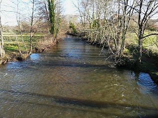
The Côle is a 51.5 km (32.0 mi) long river in the Dordogne département, south-central France. It rises near le Châtenet, a hamlet in Firbeix. It flows generally southwest. It is a left tributary of the Dronne into which it flows between Condat-sur-Trincou and Brantôme.
The canton of Haut-Périgord Noir is an administrative division of the Dordogne department, southwestern France. It was created at the French canton reorganisation which came into effect in March 2015. Its seat is in Thenon.
The canton of Isle-Manoire is an administrative division of the Dordogne department, southwestern France. It was created at the French canton reorganisation which came into effect in March 2015. Its seat is in Boulazac-Isle-Manoire.
The canton of Lalinde is an administrative division of the Dordogne department, southwestern France. Its borders were modified at the French canton reorganisation which came into effect in March 2015. Its seat is in Lalinde.
The canton of Montpon-Ménestérol is an administrative division of the Dordogne department, southwestern France. Its borders were modified at the French canton reorganisation which came into effect in March 2015. Its seat is in Montpon-Ménestérol.
The canton of Périgord Central is an administrative division of the Dordogne department, southwestern France. It was created at the French canton reorganisation which came into effect in March 2015. Its seat is in Vergt.
The canton of Terrasson-Lavilledieu is an administrative division of the Dordogne department, southwestern France. Its borders were modified at the French canton reorganisation which came into effect in March 2015. Its seat is in Terrasson-Lavilledieu.
The canton of Pays de la Force is an administrative division of the Dordogne department, southwestern France. It was created at the French canton reorganisation which came into effect in March 2015. Its seat is in Prigonrieux.
The canton of Périgord Vert Nontronnais is an administrative division of the Dordogne department, southwestern France. It was created at the French canton reorganisation which came into effect in March 2015. Its seat is in Nontron.
The canton of Saint-Astier is an administrative division of the Dordogne department, southwestern France. Its borders were modified at the French canton reorganisation which came into effect in March 2015. Its seat is in Saint-Astier.
The canton of Vallée de l'Homme is an administrative division of the Dordogne department, southwestern France. It was created at the French canton reorganisation which came into effect in March 2015. Its seat is in Montignac.
The canton of Tude-et-Lavalette is an administrative division of the Charente department, southwestern France. It was created at the French canton reorganisation which came into effect in March 2015. Its seat is in Chalais.

