Related Research Articles

The arrondissement of Bergerac is an arrondissement of France in the Dordogne department in the Nouvelle-Aquitaine region. It has 130 communes. Its population is 102,530 (2021), and its area is 1,819.9 km2 (702.7 sq mi).

The arrondissement of Nontron is an arrondissement of France in the Dordogne department in the Nouvelle-Aquitaine region. It has 94 communes. Its population is 54,127 (2021), and its area is 2,097.7 km2 (809.9 sq mi).

The arrondissement of Périgueux is an arrondissement of France in the Dordogne department in the Nouvelle-Aquitaine region. It has 143 communes. Its population is 175,870 (2021), and its area is 2,869.3 km2 (1,107.8 sq mi).

The arrondissement of Sarlat-la-Canéda is an arrondissement in France in the Dordogne department in the Nouvelle-Aquitaine region. It has 136 communes. Its population is 81,203 (2021), and its area is 2,273.1 km2 (877.6 sq mi).

The arrondissement of Libourne is an arrondissement of France in the Gironde department in the Nouvelle-Aquitaine region. It has 129 communes. Its population is 156,142 (2021), and its area is 1,282.9 km2 (495.3 sq mi).
The Canton of Brantôme en Périgord is a canton of the Dordogne department, in France. The lowest point is 63 m, and the highest point is 251 m. At the French canton reorganisation which came into effect in March 2015, the canton of Brantôme was expanded from 11 to 42 communes :
The Canton of Ribérac is a canton of the Dordogne département, in France. At the French canton reorganisation which came into effect in March 2015, the canton of Ribérac was expanded from 13 to 35 communes :

Razac-de-Saussignac is a commune in the Dordogne department in Nouvelle-Aquitaine in southwestern France.

Razac-d'Eymet is a commune in the Dordogne department in Nouvelle-Aquitaine in southwestern France.
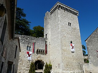
Château d'Eymet is a castle in the commune of Eymet in the Dordogne département of France.
The canton of Bergerac-1 is an administrative division of the Dordogne department, southwestern France. Its borders were modified at the French canton reorganisation which came into effect in March 2015. Its seat is in Bergerac.
The canton of Lalinde is an administrative division of the Dordogne department, southwestern France. Its borders were modified at the French canton reorganisation which came into effect in March 2015. Its seat is in Lalinde.
The canton of Vallée Dordogne is an administrative division of the Dordogne department, southwestern France. It was created at the French canton reorganisation which came into effect in March 2015. Its seat is in Saint-Cyprien.
The canton of Pays de la Force is an administrative division of the Dordogne department, southwestern France. It was created at the French canton reorganisation which came into effect in March 2015. Its seat is in Prigonrieux.
The canton of Pays de Montaigne et Gurson is an administrative division of the Dordogne department, southwestern France. It was created at the French canton reorganisation which came into effect in March 2015. Its seat is in Port-Sainte-Foy-et-Ponchapt.
The canton of Périgord Vert Nontronnais is an administrative division of the Dordogne department, southwestern France. It was created at the French canton reorganisation which came into effect in March 2015. Its seat is in Nontron.
The canton of Sarlat-la-Canéda is an administrative division of the Dordogne department, southwestern France. Its borders were modified at the French canton reorganisation which came into effect in March 2015. Its seat is in Sarlat-la-Canéda.

The canton of Les Coteaux de Dordogne is a canton of the Gironde department, Southwestern France. It was created at the canton reorganisation that came into effect in March 2015. Its seat is Castillon-la-Bataille. It elects two members of the Departmental Council of Gironde.
The canton of Le Haut Agenais Périgord is an administrative division of the Lot-et-Garonne department, southwestern France. It was created at the French canton reorganisation which came into effect in March 2015. Its seat is in Monflanquin.
Communauté d'agglomération Bergeracoise is the communauté d'agglomération, an intercommunal structure, centred on the town of Bergerac. It is located in the Dordogne department, in the Nouvelle-Aquitaine region, southwestern France. Created in 2017, its seat is in Bergerac. Its area is 586.6 km2. Its population was 60,585 in 2019, of which 26,693 in Bergerac proper.
References
44°40′N0°24′E / 44.67°N 0.40°E
| | This Dordogne geographical article is a stub. You can help Wikipedia by expanding it. |