Related Research Articles
Évreux Portes de Normandie is the communauté d'agglomération, an intercommunal structure, centred on the city of Évreux. It is located in the Eure department, in the Normandy region, northern France. It was created on 1 January 2017 by the merger of the former Communauté d'agglomération d'Évreux and the Communauté de communes La porte normande. On 1 January 2018 it was expanded with 12 communes from three other intercommunalities. Its population was 116,341 in 2015, of which 52,168 in Évreux proper.
The following is a list of the 23 cantons of the Eure department, in France, following the French canton reorganisation which came into effect in March 2015:
The arrondissement of Les Andelys is an arrondissement of France in the Eure department in the Normandy region. It has 185 communes. Its population is 235,732 (2016), and its area is 1,854.4 km2 (716.0 sq mi).

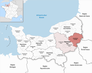
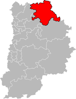
The arrondissement of Évreux is an arrondissement of France in the Eure department in the Normandy region. It has 103 communes. Its population is 140,039 (2016), and its area is 958.7 km2 (370.2 sq mi).

The arrondissement of Chartres is an arrondissement of France in the Eure-et-Loir department in the Centre-Val de Loire region. It has 148 communes. Its population is 209,218 (2016), and its area is 2,129.5 km2 (822.2 sq mi).

The canton of Coulommiers is a French administrative division, located in the arrondissement of Meaux, in the Seine-et-Marne département.
The canton of La Ferté-sous-Jouarre is a French administrative division, located in the arrondissement of Meaux, in the Seine-et-Marne département.
The canton of Évreux-Est is a former canton situated in the Eure département, France. It was disbanded following the German canton reorganisation which came into effect in March 2015. It included a part of Évreux and the communes of: Fauville, Fontaine-sous-Jouy, Gauciel, Huest, Jouy-sur-Eure, Miserey, Saint-Vigor, Sassey, La Trinité, Le Val-David and Le Vieil-Évreux.
The canton of Fère-en-Tardenois is an administrative division in northern France. At the French canton reorganisation which came into effect in March 2015, the canton was expanded from 23 to 84 communes :
The canton of Le Mesnil-Esnard is an administrative division of the Seine-Maritime department, in northern France. It was created at the French canton reorganisation which came into effect in March 2015. Its seat is in Le Mesnil-Esnard.
The canton of Les Coteaux de Moselle is an administrative division of the Moselle department, northeastern France. It was created at the French canton reorganisation which came into effect in March 2015. Its seat is in Moulins-lès-Metz.
The canton of Bourg-Achard is an administrative division of the Eure department, northern France. It was created at the French canton reorganisation which came into effect in March 2015. Its seat is in Bourg-Achard.
The canton of Bourgtheroulde-Infreville is an administrative division of the Eure department, northern France. Its borders were modified at the French canton reorganisation which came into effect in March 2015. Its seat is in Grand-Bourgtheroulde.
The canton of Romilly-sur-Andelle is an administrative division of the Eure department, northern France. It was created at the French canton reorganisation which came into effect in March 2015. Its seat is in Romilly-sur-Andelle.
The canton of Brionne is an administrative division of the Eure department, northern France. Its borders were modified at the French canton reorganisation which came into effect in March 2015. Its seat is in Brionne.
The canton of Gaillon is an administrative division of the Eure department, northern France. Its borders were modified at the French canton reorganisation which came into effect in March 2015. Its seat is in Gaillon.
The canton of Chaumont-en-Vexin is an administrative division of the Oise department, northern France. Its borders were modified at the French canton reorganisation which came into effect in March 2015. Its seat is in Chaumont-en-Vexin.
The canton of Bonnières-sur-Seine is an administrative division of the Yvelines department, northern France. Its borders were modified at the French canton reorganisation which came into effect in March 2015. Its seat is in Bonnières-sur-Seine.
The canton of Dormans-Paysages de Champagne is an administrative division of the Marne department, northeastern France. It was created at the French canton reorganisation which came into effect in March 2015. Its seat is in Dormans.
The canton of Clermont-en-Argonne is an administrative division of the Meuse department, northeastern France. Its borders were modified at the French canton reorganisation which came into effect in March 2015. Its seat is in Clermont-en-Argonne.
References
Coordinates: 49°01′N1°23′E / 49.02°N 1.38°E
| This Eure geographical article is a stub. You can help Wikipedia by expanding it. |