
The Scarpe is a river in the Hauts-de-France region of France. It is a left-bank tributary of the river Escaut (Scheldt). It is approximately 100 kilometres (62 mi) long. The source of the river is at Berles-Monchel near Aubigny-en-Artois. It flows through the towns of Arras, Douai and Saint-Amand-les-Eaux. The river ends at Mortagne-du-Nord where it flows into the Scheldt. Scarpe Mountain in Alberta, Canada, was named after the river. The navigable waterway and its coal barges also feature in the novels by 19th century author Émile Zola.
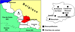
The arrondissement of Valenciennes is an arrondissement of France in the Nord department in the Hauts-de-France region. It has 82 communes.
The following is a list of the 41 cantons of the Nord department, in France, following the French canton reorganisation which came into effect in March 2015:
The canton of Saint-Quentin-3 is an administrative division in northern France. It consists of the southern part of the town of Saint-Quentin and its southern suburbs. At the French canton reorganisation which came into effect in March 2015, the canton was expanded from 6 to 9 communes:
The Canton of Aubusson is a canton situated in the Creuse département and in the Nouvelle Aquitaine region of central France.
The Canton of Bourganeuf is a canton situated in the Creuse département and in the Nouvelle Aquitaine region of central France.
The Canton of Saint-Romain-de-Colbosc is a canton situated in the Seine-Maritime département and in the Normandy region of northern France.
The Canton of Bruyères is a largely rural French administrative and electoral grouping of communes in the Vosges département of eastern France and in the region of Grand Est. The canton has its administrative centre at Bruyères.
The Canton of Brouvelieures is a former French administrative and electoral grouping of communes in the Vosges département of eastern France and in the region of Lorraine. It was disbanded following the French canton reorganisation which came into effect in March 2015. It consisted of 10 communes, which joined the canton of Bruyères in 2015.
The Canton of Saint-Amand-Montrond is a canton situated in the Cher département and in the Centre-Val de Loire region of France.
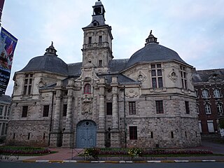
Saint-Amand Abbey, once known as Elno, Elnon or Elnone Abbey, is a former Benedictine abbey in Saint-Amand-les-Eaux, Nord, France.
The canton of Saintonge Estuaire is an administrative division of the Charente-Maritime department, western France. It was created at the French canton reorganisation which came into effect in March 2015. Its seat is in Meschers-sur-Gironde.
The canton of Denain is an administrative division of the Nord department, northern France. Its borders were modified at the French canton reorganisation which came into effect in March 2015. Its seat is in Denain.
The canton of Avesnes-sur-Helpe is an administrative division of the Nord department, northern France. It was created at the French canton reorganisation which came into effect in March 2015. Its seat is in Avesnes-sur-Helpe.
The canton of Périgord Central is an administrative division of the Dordogne department, southwestern France. It was created at the French canton reorganisation which came into effect in March 2015. Its seat is in Vergt.
The canton of La Ravoire is an administrative division of the Savoie department, southeastern France. Its borders were not modified at the French canton reorganization which came into effect in March 2015. Its seat is in La Ravoire.
The canton of Mortagne-au-Perche is an administrative division of the Orne department, northwestern France. Its borders were modified at the French canton reorganisation which came into effect in March 2015. Its seat is in Mortagne-au-Perche.
The canton of Eymoutiers is an administrative division of the Haute-Vienne department, western France. Its borders were modified at the French canton reorganisation which came into effect in March 2015. Its seat is in Eymoutiers.
The canton of Ligny-en-Barrois is an administrative division of the Meuse department, northeastern France. Its borders were modified at the French canton reorganisation which came into effect in March 2015. Its seat is in Ligny-en-Barrois.
The canton of Brassac-les-Mines is an administrative division of the Puy-de-Dôme department, central France. It was created at the French canton reorganisation which came into effect in March 2015. Its seat is in Brassac-les-Mines.

