Cantons
| Name | Population (2012) [2] | Cantonal Code | Map |
|---|---|---|---|
| Canton of Mamoudzou-1 | 17,863 | 97606 |  |
| Canton of Mamoudzou-2 | 20,303 | 97607 |  |
| Canton of Mamoudzou-3 | 19,115 | 97608 |  |
The cantons of Mamoudzou are administrative divisions of Mayotte, an overseas department and region of France. Since the French canton reorganisation which came into effect in March 2015, the city of Mamoudzou is subdivided into three cantons. Their seat is in Mamoudzou. [1]
| Name | Population (2012) [2] | Cantonal Code | Map |
|---|---|---|---|
| Canton of Mamoudzou-1 | 17,863 | 97606 | |
| Canton of Mamoudzou-2 | 20,303 | 97607 | |
| Canton of Mamoudzou-3 | 19,115 | 97608 | |
Demographic features of the population of Mayotte include population density, ethnicity, education level, health of the populace, economic status, religious affiliations and other aspects of the population. Mayotte's population density went from 179 persons per square kilometer in 1985 to 251 per square kilometer in 1991. Its capital, Dzaoudzi had a population of 5,865 according to the 1985 census; the island's largest town, Mamoudzou, had 12,026 people.

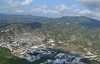
Mamoudzou is the capital city of Mayotte, a French overseas region and department in the Indian Ocean. Mamoudzou is the most populated commune (municipality) of Mayotte. It is located on Grande-Terre, the main island of Mayotte.

Dzaoudzi is a commune in the French overseas department of Mayotte, in the Indian Ocean. The commune of Dzaoudzi, made up of the twin towns of Dzaoudzi and Labattoir, is located on the small island of Petite-Terre. It was previously the capital of Mayotte, but the capital was relocated in 1977 to Mamoudzou, on the island of Grande-Terre (Maore), the main island of Mayotte.

Pamanzi, also known as Petite-Terre, is an island of Mayotte, an overseas department and region of France, and is Mayotte's second-largest island after Grande-Terre. The northern end of the island features the crater lake Dziani Dzaha, filled with sulfurous water. The communes of Dzaoudzi and Pamandzi are located on Pamanzi.
Rugby union in Mayotte is a minor but growing sport.
The Complexe de Kawani is a multi-use sports venue in Mamoudzou, Mayotte. Its central feature, the Stade Cavani holds about 5,000 people and serves the Mayotte national football team. The complex also hosts tennis, petanque, athletics, martial arts, and gymnastics.

Mtsapéré is a settlement in the French commune of Mamoudzou, Mayotte.
Kaweni is a village in the commune of Mamoudzou on the French overseas island of Mayotte.
The following is a list of the 13 cantons of the Mayotte department, in France, following the French canton reorganisation which came into effect in March 2015:
The canton of Bandraboua is an administrative division of Mayotte, an overseas department and region of France. Its borders were modified at the French canton reorganisation which came into effect in March 2015. Its seat is in Bandraboua.
The canton of Bouéni is an administrative division of Mayotte, an overseas department and region of France. Its borders were modified at the French canton reorganisation which came into effect in March 2015. Its seat is in Bouéni.
The canton of Dembeni is an administrative division of Mayotte, an overseas department and region of France. Its borders were modified at the French canton reorganisation which came into effect in March 2015. Its seat is in Dembeni.
The canton of Dzaoudzi is an administrative division of Mayotte, an overseas department and region of France. Its borders were not modified at the French canton reorganisation which came into effect in March 2015. Its seat is in Dzaoudzi.
The canton of Koungou is an administrative division of Mayotte, an overseas department and region of France. Its borders were modified at the French canton reorganisation which came into effect in March 2015. Its seat is in Koungou.
The canton of Mtsamboro is an administrative division of Mayotte, an overseas department and region of France. Its borders were modified at the French canton reorganisation which came into effect in March 2015. Its seat is in Mtsamboro.
The canton of Ouangani is an administrative division of Mayotte, an overseas department and region of France. Its borders were modified at the French canton reorganisation which came into effect in March 2015. Its seat is in Ouangani.
The canton of Pamandzi is an administrative division of Mayotte, an overseas department and region of France. Its borders were not modified at the French canton reorganisation which came into effect in March 2015. Its seat is in Pamandzi.
The canton of Sada is an administrative division of Mayotte, an overseas department and region of France. Its borders were modified at the French canton reorganisation which came into effect in March 2015. Its seat is in Sada.
The canton of Tsingoni is an administrative division of Mayotte, an overseas department and region of France. Its borders were modified at the French canton reorganisation which came into effect in March 2015. Its seat is in Tsingoni.
Zakia Madi was a Mahoran activist and a member of the Chatouilleuses and who was killed by the Comorian army during a protest in 1969. Both the market and a school in Mayotte have been renamed in her honour.
| | This Mayotte location article is a stub. You can help Wikipedia by expanding it. |