Mamoudzou

Last updated • 2 min readFrom Wikipedia, The Free Encyclopedia
Mamoudzou
Mamoudzou (10029936275).jpg
Mamoudzou
Locator map of Mamoudzou 2018.png
Location of the commune (in red) within Mayotte
Location of Mamoudzou
Mamoudzou
Coordinates: 12°46′50″S45°13′40″E / 12.7806°S 45.2278°E / -12.7806; 45.2278
Country France
Overseas region and department Mayotte
Canton 3 cantons
Intercommunality CA Dembeni-Mamoudzou
Government
  Mayor (20202026) Ambdilwahedou Soumaila [1]
Area
1
41.94 km2 (16.19 sq mi)
Population
 (2017) [2]
71,437
  Density1,700/km2 (4,400/sq mi)
Time zone UTC+03:00
INSEE/Postal code
97611 /97600
Elevation0–572 m (0–1,877 ft)
1 French Land Register data, which excludes lakes, ponds, glaciers > 1 km2 (0.386 sq mi or 247 acres) and river estuaries.

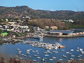
Mamoudzou (French pronunciation: [mamudzu] ; Momojou) is the capital city of Mayotte, a French overseas region and department in the Indian Ocean. Mamoudzou is the most populated commune (municipality) of Mayotte. It is located on Grande-Terre (or Maoré), the main island of Mayotte.

Contents

The commune is composed of six villages in addition to Mamoudzou. These are: Kawéni, Mtsapéré, Passamainti, Vahibé, Tsoundzou I and Tsoundzou II. The commune is also subdivided into three cantons: Mamoudzou-1, Mamoudzou-2 and Mamoudzou-3.

The government owns the radio station in Mamoudzou and broadcasts in French and Mahorian. The government departments are all situated in the town.

History

The former capital of Mayotte was Dzaoudzi, on the small island of Petite-Terre (or Pamanzi), but Mamoudzou was chosen as the capital in 1977. In the 1985 census, 12,026 people were recorded in the main town. [3]

There have been environment concerns about marine pollution in the area; "important degradation in the quality of the coastal waters" between 1977 and 2007 has been reported in the Coral Reef Lagoon in the Mamoudzou–Dzaoudzi strait, and in the Mamoudzou–Majikavo conurbation. [4]

In December 2024, Cyclone Chido destroyed most homes, administrative buildings and part of the town hall in Mamoudzou. [5]

Climate

Mamoudzou has a tropical savanna climate (Köppen climate classification Aw). The average annual temperature in Mamoudzou is 27.4 °C (81.3 °F). The average annual rainfall is 1,342.4 mm (52.85 in) with January as the wettest month. The temperatures are highest on average in April, at around 28.7 °C (83.7 °F), and lowest in August, at around 25.8 °C (78.4 °F). The highest temperature ever recorded in Mamoudzou was 34.8 °C (94.6 °F) on 21 April 2010; the coldest temperature ever recorded was 9.5 °C (49.1 °F) on 18 July 1999.

Climate data for Mamoudzou (1991–2020 averages, extremes 1999−present)
MonthJanFebMarAprMayJunJulAugSepOctNovDecYear
Record high °C (°F)34.5
(94.1)
34.2
(93.6)
34.7
(94.5)
34.8
(94.6)
34.7
(94.5)
33.2
(91.8)
32.3
(90.1)
32.2
(90.0)
33.8
(92.8)
33.4
(92.1)
33.8
(92.8)
34.0
(93.2)
34.8
(94.6)
Mean daily maximum °C (°F)30.9
(87.6)
31.2
(88.2)
31.9
(89.4)
32.3
(90.1)
31.4
(88.5)
30.1
(86.2)
29.3
(84.7)
29.6
(85.3)
30.1
(86.2)
30.7
(87.3)
30.9
(87.6)
31.1
(88.0)
30.8
(87.4)
Daily mean °C (°F)27.9
(82.2)
28.1
(82.6)
28.5
(83.3)
28.7
(83.7)
28.0
(82.4)
26.8
(80.2)
25.9
(78.6)
25.8
(78.4)
26.2
(79.2)
27.0
(80.6)
27.6
(81.7)
28.0
(82.4)
27.4
(81.3)
Mean daily minimum °C (°F)25.0
(77.0)
25.0
(77.0)
25.1
(77.2)
25.1
(77.2)
24.6
(76.3)
23.5
(74.3)
22.4
(72.3)
22.0
(71.6)
22.3
(72.1)
23.3
(73.9)
24.3
(75.7)
24.9
(76.8)
24.0
(75.2)
Record low °C (°F)21.6
(70.9)
22.0
(71.6)
21.5
(70.7)
22.0
(71.6)
21.7
(71.1)
20.5
(68.9)
18.5
(65.3)
19.5
(67.1)
19.8
(67.6)
18.6
(65.5)
21.8
(71.2)
22.0
(71.6)
18.5
(65.3)
Average precipitation mm (inches)315.1
(12.41)
257.3
(10.13)
251.9
(9.92)
86.5
(3.41)
40.6
(1.60)
22.2
(0.87)
11.8
(0.46)
15.6
(0.61)
23.4
(0.92)
49.9
(1.96)
97.2
(3.83)
170.9
(6.73)
1,342.4
(52.85)
Average precipitation days (≥ 1.0 mm)16.514.414.57.54.03.02.52.53.14.97.812.192.8
Source: Météo-France [6]

Administration

Mamoudzou City Hall Mamoudzou City Hall (10030018363).jpg
Mamoudzou City Hall

The commune is composed of six villages in addition to its central habitation, also called Mamoudzou. These are: Kawéni, Mtsapéré, Passamainti, Vahibé, Tsoundzou I and Tsoundzou II.

The commune is also subdivided into three cantons: Mamoudzou-1, Mamoudzou-2 and Mamoudzou-3.

The government owns the radio station in Mamoudzou and broadcasts in French and Mahorian. The government departments, including Agriculture and Forestry, Education, Health and Social Security, Public Works, Work, Employment and training and Youth and Sports are situated on the Rue Mariaze in the town. [7] The government departments have been based in the town since before it became the capital, from World War II. France Télécom operates in the town. [8]

Population

Historical population
YearPop.±% p.a.
1966 4,556    
1978 7,798+4.58%
1985 12,026+6.38%
1991 20,307+9.12%
1997 32,733+8.28%
2002 45,485+6.80%
2007 53,122+3.15%
2012 57,281+1.52%
2017 71,437+4.52%
Source: SPLAF (1966-2007) [9] and INSEE (2012-2017) [10] [11]
Village Populations
Village19972002
Kavani3 9485 488
Kaweni6 2069 604
Mamoudzou5 6666 533
Mtsapéré6 97910 495
Passamainty5 1736 008
Tsountsou 12 0933 058
Tsountsou 25741 063
Vahibé2 1353 236
Statistics accurate as of 1997

Economy

Place du Marche Marche-Mamoudzou-2.jpg
Place du Marché

Mamoudzou has a bank and shopping centre. The economic centre of the town is the Place du Marche, where the bank, Air France and Ewa Air offices, and the tourist office are located. [12] The headquarters of the magazine Jana na Leo , "primarily concerned with articles on social life of the island of Mahore", is published in Mamoudzou. [13] Noteworthy restaurants in Mamoudzou include the Les Terrasses, Hotel Restaurant Isijiva, Le Barfly and Mamoudzou La Kaz. [14]

Ferry in motion between Dzaoudzi and Mamoudzou Mayotte Bac.JPG
Ferry in motion between Dzaoudzi and Mamoudzou

A ferry service is provided for tourists to the island of Petite Terre. [15]

Notable people

Religion

Churches

Related Research Articles

<span class="mw-page-title-main">Mayotte</span> Overseas department of France in the Indian Ocean

Mayotte, officially the Department of Mayotte, is an overseas department and region and single territorial collectivity of France. It is located in the northern part of the Mozambique Channel in the Indian Ocean off the coast of Southeastern Africa, between Northwestern Madagascar and Northeastern Mozambique. Mayotte consists of a main island, Grande-Terre, a smaller island, Petite-Terre, as well as several islets around these two.

Demographic features of the population of Mayotte include population density, ethnicity, education level, health of the populace, economic status, religious affiliations and other aspects of the population. Mayotte's population density went from 179 persons per square kilometer in 1985 to 251 per square kilometer in 1991. Its capital, Dzaoudzi had a population of 5,865 according to the 1985 census; the island's largest town, Mamoudzou, had 12,026 people.

<span class="mw-page-title-main">Moroni, Comoros</span> Capital of Comoros

Moroni is the largest city, national capital, and seat of the government of the Union of the Comoros, a sovereign archipelago nation in the Indian Ocean. Moroni means "at the river". Moroni is the capital of the semi-autonomous island of Ngazidja, the largest of the three main islands of the republic. The city's estimated population in 2003 was 41,557 residents. Moroni, which lies along the Route Nationale 1, has a port and several mosques such as the Badjanani Mosque.

<span class="mw-page-title-main">Comoro Islands</span> Archipelago in the Indian Ocean

The Comoro Islands are a group of volcanic islands in the Mozambique Channel, an arm of the Indian Ocean lying between Madagascar and the African mainland. Three of the islands form the Union of the Comoros, a sovereign nation, while Mayotte belongs to France.

<span class="mw-page-title-main">Koungou</span> Commune in Mayotte, France

Koungou is the second largest commune in the French overseas department of Mayotte, in the Indian Ocean, after the capital Mamoudzou. It is composed of six villages: Majicavo Lamir, Majicavo Koropa, Koungou, Trévani, Kangani and Longoni.

<span class="mw-page-title-main">Mtsamboro</span> Commune in Mayotte, France

Mtsamboro is a small fishing town and commune in northwest Mayotte, a French overseas department in the Indian Ocean. Its population according to the 2017 census is 7,705. Included in the commune are the Choazil Islands and Chissioua Mtsamboro. The main economic activity is fishing and orange production.

<span class="mw-page-title-main">Dzaoudzi</span> Commune in Mayotte, France

Dzaoudzi is a commune in the French overseas department of Mayotte, in the Indian Ocean. The commune of Dzaoudzi, made up of the twin towns of Dzaoudzi and Labattoir, is located on the small island of Petite-Terre. It was previously the capital of Mayotte, but the capital was relocated in 1977 to Mamoudzou, on the island of Grande-Terre (Maore), the main island of Mayotte.

<span class="mw-page-title-main">Pamandzi</span> Commune in Mayotte, France

Pamandzi is a commune in the French overseas department of Mayotte, in the Indian Ocean. The commune of Pamandzi is located on the small island of Petite-Terre, off the main island of Mayotte.

<span class="mw-page-title-main">Pamanzi</span>

Pamanzi, also known as Petite-Terre, is an island of Mayotte, an overseas department and region of France, and is Mayotte's second-largest island after Grande-Terre. The northern end of the island features the crater lake Dziani Dzaha, filled with sulfurous water. The communes of Dzaoudzi and Pamandzi are located on Pamanzi.

<span class="mw-page-title-main">Dzaoudzi–Pamandzi International Airport</span> Airport in Pamandzi, Mayotte

Dzaoudzi–Pamandzi International Airport is an airport located in Pamandzi, Mayotte, France on the southern tip of the island of Petite-Terre, east of Grande-Terre, the main island of Mayotte. It is the only airport in Mayotte with scheduled services, mainly to destinations within Africa and to metropolitan France. The airport is currently able to service aircraft up to the Boeing 777 in size.

<span class="mw-page-title-main">Communes of Mayotte</span>

The French overseas department of Mayotte is divided into 17 communes.

<span class="mw-page-title-main">Vahibé</span> Village in a French department in the Indian Ocean

Vahibé is a village in the commune of Mamoudzou on Mayotte.

<span class="mw-page-title-main">Outline of Mayotte</span> Overview of and topical guide to Mayotte

Mayotte – overseas department of France located in the Comoros Archipelago in the Indian Ocean. The department comprises the main island of Grande-Terre, a smaller island, Petite-Terre, and several islets at the northern end of the Mozambique Channel, between northern Madagascar and northern Mozambique. The territory is geographically part of the Comoro Islands, but has been politically separate since the 1970s. The territory is also known as Mahoré, the native name of its main island, especially by advocates of its inclusion in the Union of Comoros.

<span class="mw-page-title-main">St. Michael's Church, Dzaoudzi</span> Church in Mayotte, France

The St. Michael's Church or simply the Church of Dzaoudzi, is a religious building belonging to the Catholic Church and is located in the town of Dzaoudzi in the French overseas department of Mayotte, in the Indian Ocean.

The ongoing COVID-19 pandemic was confirmed to have reached the French overseas department and region of Mayotte on 10 March 2020. On 31 March, the first person died of COVID-19. In late April, the virus was out of control, and actively circulating on the island. On 16 August, Mayotte has been green listed.

Zaïna Meresse, born Boinali on June 18, 1935, in Bandrele and died on April 11, 2014, in Mamoudzou, was a Mahorese activist and politician.

Zéna M'Déré was a Mayotte woman best known as the leader of the Chatouilleuses, a movement of women who fought to maintain Mayotte's status as a French overseas department rather than joining Comoros in declaring independence, notably through the use of tickle torture on political leaders.

<span class="mw-page-title-main">Operation Wuambushu</span> French military operation

Operation Wuambushu is an ongoing French military-police operation in Mayotte, aimed at expelling illegal immigrants, destroying slums, and fighting crime on the islands.

Office de Radio et Télévision des Comores or ORTC is the national public radio and television company of the Comoros. It broadcasts a radio station and a television channel in Comorian, French and Arabic: ORTC-TV.

<span class="mw-page-title-main">Cyclone Chido</span> South-West Indian Ocean tropical cyclone in 2024

Intense Tropical Cyclone Chido was a small but powerful and deadly tropical cyclone which impacted Southeast Africa in December 2024. The fourth tropical disturbance, the second tropical cyclone, and the second intense tropical cyclone of the 2024–25 South-West Indian Ocean cyclone season, Chido formed from a tropical disturbance southeast of Diego Garcia that was first noted on 5 December 2024. It continued westward, and steadily intensified before being named Chido on 8 December. After it underwent rapid intensification, Chido made landfall at Agaléga in Mauritius on 11 December, peaking in intensity the following day. After passing through northern Madagascar, Chido briefly weakened but quickly regained intensity, before making its second landfall near Bandraboua, Mayotte on 14 December, before slightly weakening again later that day and making a third landfall near Pemba, Mozambique the following day; Chido made all three of its landfalls as a Category 4-equivalent intense tropical cyclone.

References

  1. "Répertoire national des élus: les maires" (in French). data.gouv.fr, Plateforme ouverte des données publiques françaises. 13 September 2022.
  2. Populations légales de Mayotte en 2017, INSEE
  3. Wright, John (23 May 2006). New York Times Almanac 2002. Routledge. p. 1589. ISBN   978-1-135-45586-6.
  4. Ceccaldi, Hubert J. (12 January 2011). Global Change: Mankind-Marine Environment Interactions: Proceedings of the 13th French-Japanese Oceanography Symposium. Springer Science & Business Media. p. 407. ISBN   978-90-481-8630-3.
  5. "Cyclone Chido: "S'il n'y a pas de morts ou de blessés, ça serait vraiment un miracle", selon le président de l'association des maires de Mayotte" (in French). France Info. 14 December 2024. Retrieved 14 December 2024.
  6. "Fiche Climatologique Statistiques 1991-2020 et records" (PDF). Météo-France . Retrieved 26 August 2022.
  7. Africa South of the Sahara 2003. Psychology Press. 31 October 2002. p. 243. ISBN   978-1-85743-131-5.
  8. Routledge (9 November 2007). Africa South of the Sahara 2008. Taylor & Francis. ISBN   9781857434217.
  9. Description de Mayotte, SPLAF
  10. Populations légales des communes de Mayotte en 2012, INSEE
  11. Populations légales des communes de Mayotte en 2017, INSEE
  12. Hodd, Michael (1994). East African Handbook. Trade & Travel Publications. p. 706. ISBN   978-0-8442-8983-0.
  13. Ottenheimer, Martin (1 January 1994). Historical Dictionary of the Comoro Islands. Scarecrow Press. p. 92. ISBN   978-0-8108-2819-3.
  14. Nourault, Gilles; Perrin, François (2003). Mayotte: guide touristique et culturel (in French). Orphie. p. 315. ISBN   9782877632072.
  15. Madagascar & Comoros. Lonely Planet. 2008. p. 257. ISBN   978-1-74104-608-3.