Dzaoudzi

Last updated
Dzaoudzi
Dzaoudzi (2851879391).jpg
Dzaoudzi harbour
Locator map of Dzaoudzi 2018.png
Location of the commune (in red) within Mayotte
Location of Dzaoudzi
Dzaoudzi
Coordinates: 12°47′24″S45°16′50″E / 12.79°S 45.2806°E / -12.79; 45.2806
Country France
Overseas region and department Mayotte
Canton Dzaoudzi
Intercommunality Petite-Terre
Government
  Mayor (20232026) Mikidache Houmadi [1]
Area
1
6.66 km2 (2.57 sq mi)
Population
 (2017) [2]
17,831
  Density2,700/km2 (6,900/sq mi)
Time zone UTC+03:00
INSEE/Postal code
97608 /97615
1 French Land Register data, which excludes lakes, ponds, glaciers > 1 km2 (0.386 sq mi or 247 acres) and river estuaries.

Dzaoudzi (French pronunciation: [dzaudzi] ) is a commune in the French overseas department of Mayotte, in the Indian Ocean. The commune of Dzaoudzi (sometimes called Dzaoudzi-Labattoir [dzaudzilabatwaʁ] ), made up of the twin towns of Dzaoudzi and Labattoir, is located on the small island of Petite-Terre (or Pamanzi). It was previously the capital of Mayotte, but the capital was relocated in 1977 to Mamoudzou, on the island of Grande-Terre (Maore), the main island of Mayotte.

Contents

The Foreign Legion Detachment in Mayotte has been based in Dzaoudzi [3] since 1973.

Geography

The town of Dzaoudzi is located on a rocky outcropping which was once a separate islet. It is now linked to Pamanzi Island and the rest of Dzaoudzi Commune by the Boulevard des Crabes, a road constructed atop an artificial dike.

Climate

Dzaoudzi features a tropical wet and dry climate under the Köppen climate classification. The wet season spans from December through April while the dry season covers the remaining seven months. Dzaoudzi is slightly cooler during the peak of its dry season with average temperatures hovering around 23 °C (73 °F) during its cooler period. Average temperatures are 27 °C (81 °F) during its warmest period. The town sees roughly 1,000 millimetres (39 in) of precipitation annually.

Climate data for Dzaoudzi
MonthJanFebMarAprMayJunJulAugSepOctNovDecYear
Record high °C (°F)35
(95)
34
(93)
33
(91)
33
(91)
33
(91)
31
(88)
30
(86)
32
(90)
32
(90)
33
(91)
35
(95)
37
(99)
37
(99)
Mean daily maximum °C (°F)30
(86)
30
(86)
30
(86)
30
(86)
28
(82)
27
(81)
26
(79)
26
(79)
28
(82)
29
(84)
31
(88)
31
(88)
29
(84)
Mean daily minimum °C (°F)24
(75)
24
(75)
24
(75)
24
(75)
23
(73)
22
(72)
21
(70)
21
(70)
21
(70)
22
(72)
23
(73)
24
(75)
23
(73)
Record low °C (°F)20
(68)
21
(70)
20
(68)
20
(68)
17
(63)
16
(61)
16
(61)
16
(61)
17
(63)
13
(55)
18
(64)
21
(70)
13
(55)
Average precipitation mm (inches)250
(9.8)
210
(8.3)
180
(7.2)
86
(3.4)
36
(1.4)
10
(0.4)
7.6
(0.3)
10
(0.4)
20
(0.8)
48
(1.9)
58
(2.3)
140
(5.6)
1,060
(41.6)
Average relative humidity (%)82838482797977798078797880
Source: Weatherbase [4]

Demographics

The commune is home to 17,831 (Census 2017), [2] the majority of whom live in the town of Labattoir.

Historical population
YearPop.±% p.a.
19662,967    
19784,147+2.83%
19855,865+5.08%
19918,257+5.87%
199710,792+4.56%
200212,308+2.66%
200715,354+4.52%
201214,311−1.40%
201717,831+4.50%
Source: SPLAF (1966-2007) [5] and INSEE (2012-2017) [6] [2]

Transportation

Ferry in motion between Dzaoudzi and Mamoudzou Mayotte Bac.JPG
Ferry in motion between Dzaoudzi and Mamoudzou

A system of ferry barges operated by the Société des Transports Maritimes link Dzaoudzi to the island of Grande-Terre.

The Dzaoudzi Pamandzi International Airport, the main airport of Mayotte, is located on Pamanzi Island in the neighboring commune of Pamandzi.

See also

Related Research Articles

<span class="mw-page-title-main">Geography of the Comoros</span>

The Comoros archipelago consists of four main islands aligned along a northwest–southeast axis at the north end of the Mozambique Channel, between Mozambique and the island of Madagascar. Still widely known by their French names, the islands officially have been called by their Swahili names by the Comorian government. They are Grande Comore (Njazidja), Mohéli (Mwali), Anjouan (Nzwani), and Mayotte (Mahoré). The islands' distance from each other—Grande Comore is some 200 kilometers from Mayotte, forty kilometers from Mohéli, and eighty kilometers from Anjouan—along with a lack of good harbor facilities, make transportation and communication difficult. Comoros are sunny islands.

<span class="mw-page-title-main">Mayotte</span> Overseas department of France in the Indian Ocean

Mayotte, officially the Department of Mayotte, is an overseas department and region and single territorial collectivity of France. It is located in the northern part of the Mozambique Channel in the Indian Ocean off the coast of Southeastern Africa, between Northwestern Madagascar and Northeastern Mozambique. Mayotte consists of a main island, Grande-Terre, a smaller island, Petite-Terre, as well as several islets around these two. Mayotte is the most prosperous territory in the Mozambique Channel, making it a major destination for immigration.

<span class="mw-page-title-main">Anse-Bertrand</span> Commune in Guadeloupe, France

Anse-Bertrand is a commune in Guadeloupe, an overseas region and department of France in the Lesser Antilles.

<span class="mw-page-title-main">Baillif</span> Commune in Guadeloupe, France

Baillif is a commune of Guadeloupe, an overseas region and department of France located in the Lesser Antilles. Baillif is a suburb of Basse-Terre, the prefecture and second-largest urban area of Guadeloupe located on Basse-Terre Island.

<span class="mw-page-title-main">Pointe-à-Pitre</span> Subprefecture, commune, and the center of the largest metropolitan area in Guadeloupe

Pointe-à-Pitre is the second most populous commune of Guadeloupe. Guadeloupe is an overseas region and department of France located in the Lesser Antilles, of which it is a sous-préfecture, being the seat of the Arrondissement of Pointe-à-Pitre.

<span class="mw-page-title-main">Papeete</span> Capital city of French Polynesia

Papeete is the capital city of French Polynesia, an overseas collectivity of the French Republic in the Pacific Ocean. The commune of Papeete is located on the island of Tahiti, in the administrative subdivision of the Windward Islands, of which Papeete is the administrative capital. Both the President of French Polynesia and French High Commissioner reside in Papeete.

<span class="mw-page-title-main">Cayenne</span> Capital city of French Guiana

Cayenne is the prefecture of French Guiana, an overseas region and department of France located in South America. The city stands on a former island at the mouth of the Cayenne River on the Atlantic coast. The city's motto is "fert aurum industria", which means "work brings wealth". Cayenne is the largest Francophone city of the South American continent.

<span class="mw-page-title-main">Comoro Islands</span> Archipelago in the Indian Ocean

The Comoro Islands or the Comoros are an archipelago of volcanic islands situated off the southeastern coast of Africa, to the east of Mozambique and northwest of Madagascar. The islands are politically divided between the Union of the Comoros, a sovereign country, and Mayotte, an Overseas Department of France.

<span class="mw-page-title-main">Mamoudzou</span> Place in Mayotte, France

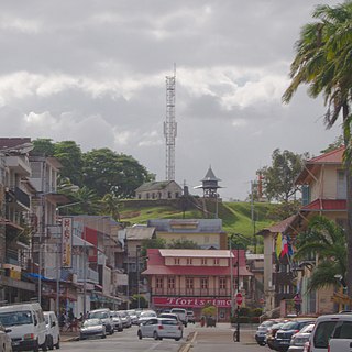
Mamoudzou is the capital city of Mayotte, a French overseas region and department in the Indian Ocean. Mamoudzou is the most populated commune (municipality) of Mayotte. It is located on Grande-Terre, the main island of Mayotte.

<span class="mw-page-title-main">Saint-Pierre, Réunion</span> Subprefecture and commune in Réunion, France

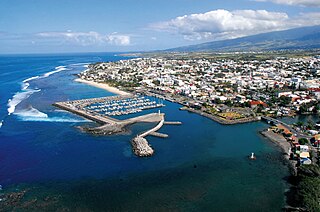
Saint-Pierre is the third-largest commune in the French overseas department and region of Réunion. Located on the southwest side of the island, it is the capital of the French Southern and Antarctic Lands. It developed from a port built from 1854 to 1882, which was used for the trade between Asia and Europe. Today, it features 400 sites for fishing and pleasure boats, while most of the commercial traffic moved north to Le Port.

<span class="mw-page-title-main">Saint-Paul, Réunion</span> Subprefecture and commune in Réunion, France

Saint-Paul is the second-largest commune in the French overseas department of Réunion. It is located on the extreme west side of the island of Réunion.

<span class="mw-page-title-main">Dembeni</span> Commune in Mayotte, France

Dembeni is a commune in the French overseas department of Mayotte, in the Indian Ocean.

<span class="mw-page-title-main">Pamandzi</span> Commune in Mayotte, France

Pamandzi is a commune in the French overseas department of Mayotte, in the Indian Ocean. The commune of Pamandzi is located on the small island of Petite-Terre, off the main island of Mayotte.

<span class="mw-page-title-main">Touho</span> Commune in New Caledonia, France

Touho is a municipality (commune) in the North Province of New Caledonia, an overseas territory of France in the Pacific Ocean. Touho lies on the east coast of the main island and is served by a road and an airfield.

<span class="mw-page-title-main">La Possession</span> Commune in Réunion, France

La Possession is a commune in the French overseas department of Réunion. It is located in the northwestern part of the island of Réunion, between the capital of Saint-Denis and the commune of Le Port.

<span class="mw-page-title-main">Pamanzi</span>

Pamanzi, also known as Petite-Terre, is an island of Mayotte, an overseas department and region of France, and is Mayotte's second-largest island after Grande-Terre. The northern end of the island features the crater lake Dziani Dzaha, filled with sulfurous water. The communes of Dzaoudzi and Pamandzi are located on Pamanzi.

<span class="mw-page-title-main">Dzaoudzi–Pamandzi International Airport</span> Airport in Pamandzi, Mayotte

Dzaoudzi–Pamandzi International Airport is an airport located in Pamandzi, Mayotte, France on the southern tip of the island of Petite-Terre, east of Grande-Terre, the main island of Mayotte. It is the only airport in Mayotte with scheduled services, mainly to destinations within Africa and to metropolitan France. The airport is currently able to service aircraft up to the Boeing 777 in size.

<span class="mw-page-title-main">Communes of Mayotte</span>

The French overseas department of Mayotte is divided into 17 communes.

<span class="mw-page-title-main">Lagamas</span> Commune in Occitania, France

Lagamas is a commune in the Hérault département in the Occitanie region in southern France.

References

  1. "Répertoire national des élus: les maires" (in French). data.gouv.fr, Plateforme ouverte des données publiques françaises. 16 April 2024.
  2. 1 2 3 Populations légales de Mayotte en 2017, INSEE
  3. Ministry of Defense (in French).
  4. "Weatherbase: Historical Weather for Dzaoudzi, Mayotte". Weatherbase. 2014. Retrieved on April 12, 2014.
  5. Description de Mayotte, SPLAF.
  6. Populations légales des communes de Mayotte en 2012, INSEE.