Mayotte, officially the Department of Mayotte, is an overseas department and region and single territorial collectivity of France. It is located in the northern part of the Mozambique Channel in the Indian Ocean off the coast of Southeastern Africa, between Northwestern Madagascar and Northeastern Mozambique. Mayotte consists of a main island, Grande-Terre, a smaller island, Petite-Terre, as well as several islets around these two. Mayotte is the most prosperous territory in the Mozambique Channel, making it a major destination for immigration.

France is divided into eighteen administrative regions, of which thirteen are located in metropolitan France, while the other five are overseas regions.

Mamoudzou is the capital of Mayotte, a French overseas region and department in the Indian Ocean. Mamoudzou is the most populated commune (municipality) of Mayotte. It is located on Grande-Terre, the main island of Mayotte.

Koungou is the second largest commune in the French overseas department of Mayotte, in the Indian Ocean, after the capital Mamoudzou. It is composed of six villages: Majicavo Lamir, Majicavo Koropa, Koungou, Trévani, Kangani and Longoni.

Sada is a commune in the French overseas department of Mayotte, in the Indian Ocean.

Dzaoudzi is a commune in the French overseas department of Mayotte, in the Indian Ocean. The commune of Dzaoudzi, made up of the twin towns of Dzaoudzi and Labattoir, is located on the small island of Petite-Terre. It was previously the capital of Mayotte, but the capital was relocated in 1977 to Mamoudzou, on the island of Grande-Terre (Maore), the main island of Mayotte.

Dzaoudzi–Pamandzi International Airport is an airport located in Dzaoudzi, Mayotte, France on the southern tip of the island of Petite-Terre, located east of Grande-Terre, the main island of Mayotte. It is the only airport in Mayotte with scheduled services, mainly to destinations within Africa and to metropolitan France. The airport services aircraft up to the Boeing 777 in size.

The French overseas department of Mayotte is divided into 17 communes.
The postage stamps and postal history of the Comoro Islands is an overview of the postage stamps and postal history of the Comoro Islands, an Indian Ocean archipelago located on the south-east side of Africa.
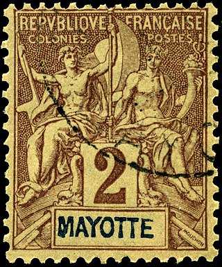
This is an overview of the postage stamps and postal history of the Indian Ocean island of Mayotte, one of the Comoros Archipelago islands located on the south-east side of Africa.
Bushi or Kibosy is a dialect of Malagasy spoken in the Indian Ocean island of Mayotte. Malagasy dialects most closely related to Bushi are spoken in northwestern Madagascar in the area of Antsiranana (Diego-Suarez) and Mahajanga (Majunga), which is also the closest point in Madagascar to Mayotte. Kibosy and Majunga together are considered one of the Malagasy languages by Glottolog.
Mtsangadoua is a village in the commune of Acoua on Mayotte.

The 1st constituency of Mayotte is a French legislative constituency on the island of Mayotte.

Overseas France consists of 13 French-administered territories outside Europe, mostly the remains of the French colonial empire that chose to remain a part of the French state under various statuses after decolonization. They are part of the European Union. This collective name is used in everyday life in France but is not an administrative designation in its own right. Instead, the five overseas regions have exactly the same administrative status as the metropolitan regions; the five overseas collectivities are semi-autonomous; and New Caledonia is an autonomous territory. Overseas France includes island territories in the Atlantic, Pacific and Indian Oceans, French Guiana on the South American continent, and several peri-Antarctic islands as well as a claim in Antarctica. Excluding the district of Adélie Land, where French sovereignty is effective de jure by French law, but where the French exclusive claim on this part of Antarctica is frozen by the Antarctic Treaty, overseas France covers a land area of 120,396 km2 (46,485 sq mi) and accounts for 18.0% of the French Republic's land territory. Its exclusive economic zone (EEZ) of 9,825,538 km2 (3,793,661 sq mi) accounts for 96.7% of the EEZ of the French Republic.
The Mayotte Rugby Committee is a committee under the umbrella of the French Rugby Federation which is the governing body for rugby union within Mayotte.

The 2nd constituency of Mayotte is a French legislative constituency on the island of Mayotte.
A by-election was held in Mayotte's 1st constituency on 18 March 2018, with a second round on 25 March as no candidate secured a majority of votes in the first round. The by-election was called after the Constitutional Council invalidated the election of Ramlati Ali, candidate of the Socialist Party (PS) in the June 2017 legislative elections and member of the La République En Marche group in the National Assembly, on 19 January 2018.

The ongoing COVID-19 pandemic was confirmed to have reached the French overseas department and region of Mayotte on 10 March 2020. On 31 March, the first person died of COVID-19. In late April, the virus was out of control, and actively circulating on the island. On 16 August, Mayotte has been green listed.


