Cap d'Artrutx Lighthouse

Last updated

Cap d'Artrutx Lighthouse
Cap d'Artrutx.jpg
Cap d'Artrutx Lighthouse
LocationCap d'Artrutx
Menorca
Balearic Islands
Spain
Coordinates 39°55′21″N3°49′27″E / 39.922532°N 3.824190°E / 39.922532; 3.824190
Tower
Constructed1859
Height34 metres (112 ft)
Shapecylindrical tower with buttresses, double balcony and lantern
Markingswhite tower with black bands
Heritage Bien de Interés Cultural   OOjs UI icon edit-ltr-progressive.svg
Light
Focal height45 metres (148 ft)
Range18 nautical miles (33 km; 21 mi)
Characteristic Fl(3) W 10s.
Spain no.ES-36420

The Cap d'Artrutx Lighthouse or Artrutx Lighthouse (Catalan : Far d'Artrutx) is an active 19th century lighthouse located on the low-lying headland of the same name on the Spanish island of Menorca. It was completed in 1859 but the tower was significantly increased in height in 1969. Automated in 1980, the keeper's accommodation is now used as a restaurant.

Contents

Cap d'Artrutx

The Cap d'Artrutx is a headland at the extreme south-western point of the island, which gives it name to the surrounding urbanisation made up of modern villas and apartments. Located adjacent to the larger resort of Cala en Bosch which lies to the east, it is connected to the rest of the island by the Me 24 road. The area is also served by a regular bus service to the nearby town of Ciutadella. The Camí de Cavalls a long distance footpath that circumnavigates the island, passes along the coast to the cape. It marks the end of the stage from Ciutadella and the start of the next section to Cala en Turqueta. [1] [2]

History

Detail of the tower Cap dArtrutx (8948406425).jpg
Detail of the tower

Designed by the architect Emili Pou who planned a number of lights in the Balearic Islands. It first became operational in July 1859, and was equipped with a 4th order Fresnel lens. The optics were supplied by Henry Lapute of Paris at a cost of 3,250 francs. [3]

The original tower was much shorter than that seen today, with a height of only 17 metres. Reverberations from waves entering a sea cave nearby caused problems within the lighthouse producing "tremors in the building and panes of glass in the lantern to shatter". [3] In 1967, a new maritime lighting plan for the Balearics was drawn up which outlined the need for a higher tower at Artrutx. When the new tower was constructed in 1969, the 34-metre-high (112 ft) cylindrical structure was built with four buttresses or ribs, giving the light a unique shape in comparison to others in the archipelago. [3]

With the automation of the lighthouse in 1980, the unused keeper's accommodation was later converted into a bar and restaurant, providing food and drink to patrons who visit to watch the sunset on the terrace. [4] The lighthouse can be visited when the restaurant is open, but the tower is closed. [5]

In 2005 the lighthouse became a registered historical site when it was declared a Patrimonio histórico español. [6]

Operation

With a focal height of 45 metres above sea level, the light which displays a pattern of three white flashes every 10 seconds can be seen for 18 nautical miles. [3] It marks the eastern side of the Menorca Channel, a strait that separates Majorca and Menorca. [7] On the opposite side of the channel is another 19th-century lighthouse, at Capdepera, which was also designed by Emili Pou. [5]

The lighthouse is operated and maintained by the Port Authority of the Balearic Islands, and is registered under the international Admiralty number E0342 and has the NGA identifier of 113-5184. [5]

See also

Related Research Articles

<span class="mw-page-title-main">Formentera</span> Spanish island in the Balearic Islands

Formentera is a Spanish island located in the Mediterranean Sea, which belongs to the Balearic Islands autonomous community (Spain) together with Mallorca, Menorca, and Ibiza.

<span class="mw-page-title-main">Menorca</span> Island in Spain

Menorca or Minorca is one of the Balearic Islands located in the Mediterranean Sea belonging to Spain. Its name derives from its size, contrasting it with nearby Mallorca. Its capital is Mahón, situated on the island's eastern end, although Menorca is not a province and forms a political union with the other islands in the archipelago. Ciutadella and Mahón are the main ports and largest towns. The port of Mahón is the second biggest natural port in the world.

<span class="mw-page-title-main">Ciutadella de Menorca</span> Municipality in the Balearic Islands, Spain

Ciutadella de Menorca or simply Ciutadella is a town and a municipality in the western end of Menorca, one of the Balearic Islands (Spain). It is one of the two primary cities in the island, along with Maó.

<span class="mw-page-title-main">Cap de Formentor</span> Northernmost point of Mallorca, Spain

Cap de Formentor is the northernmost point of Mallorca, on the Formentor peninsula.

<span class="mw-page-title-main">Dragonera</span> Island in Balearic Islands, Spain

Sa Dragonera is an uninhabited islet in the Balearic Islands, Spain, located just off the west coast of Majorca. It is currently a natural park, Parc Natural Sa Dragonera.

<span class="mw-page-title-main">Balearic Islands</span> Archipelago in the Mediterranean, autonomous community, and province of Spain

The Balearic Islands are an archipelago in the western Mediterranean Sea, near the eastern coast of the Iberian Peninsula. The archipelago forms a province and autonomous community of Spain, with Palma de Mallorca being its capital and largest city.

The Divisiones Regionales de Fútbol in the Balearic Islands, are organized by Balearic Football Federation :

<span class="mw-page-title-main">Menorquín horse</span> Breed of horse from Menorca

The Menorquín or Catalan: Cavall Menorquí is a breed of horse indigenous to the island of Menorca in the Balearic Islands, from which it takes its name. It is closely associated with the doma menorquina style of riding.

<span class="mw-page-title-main">Cala en Bosch</span> Resort town in Balearic Islands, Spain

Cala en Bosch, also known as Cala'n Bosch or Cala en Bosc, is a beach, marina, hotel, and apartment resort located on the southwest coast of Menorca, one of the Balearic Islands in Spain. It is situated approximately 9 kilometres south of the town of Ciutadella de Menorca. The area is bordered by the neighborhoods of Son Xoriguer to the east and Cap d'Artrutx, which is the southwestern point of the island and home to the prominent Lighthouse of Artrutx. Cala en Bosch offers scuba diving facilities, making it an attractive destination for underwater enthusiasts.

<span class="mw-page-title-main">Balearic donkey</span> Breed of domestic donkey from the Balearic Islands

The Balearic, Catalan: Ase Balear, Spanish: Asno Balear, is a Spanish breed of domestic donkey indigenous to the autonomous community of the Balearic Islands, in the Mediterranean off the eastern coast of Spain. It is found mainly in Mallorca, the largest island of the group, and also in Menorca, where it was much used for mule-breeding; it is no longer present in the islands of Eivissa and Formentera. Since 2006 it has been officially called the Raça Asenca Balear; it was previously known as the Raça Asenca Mallorquina, and was also referred to as the Ase MallorquÍ, Asno Mallorquín or Mallorquín.

<span class="mw-page-title-main">Illa de l'Aire Lighthouse</span> Lighthouse on Menorca, Spain

The Illa de l’Aire Lighthouse is an active lighthouse on the islet of Illa de l'Aire, on the southeast coast of the Spanish island of Menorca.

<span class="mw-page-title-main">Ciutadella Lighthouse</span> Lighthouse on Menorca, Spain

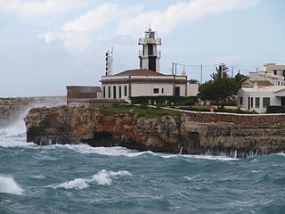
The Ciutadella, Punta de Sa Farola or Sa Farola Lighthouse is an active 19th century lighthouse on the Spanish island of Menorca. Originally completed in 1863, the tower has subsequently undergone a number of modifications. It lies close to the seaward entrance of the port of Ciutadella on the Sa Farola point, at the western end of the island. On the opposite headland is the Castell de Sant Nicolau, a 17th-century defensive tower.

<span class="mw-page-title-main">Punta Nati Lighthouse</span> Lighthouse on the island of Menorca, Spain

The Punta Nati Lighthouse is an active aid to navigation located on the rocky north western coast of the Spanish island of Menorca.

<span class="mw-page-title-main">Favàritx Lighthouse</span> Lighthouse on Menorca, Spain

The Favàritx Lighthouse is an active lighthouse on the Spanish island of Menorca.

<span class="mw-page-title-main">2015 Balearic regional election</span>

The 2015 Balearic regional election was held on Sunday, 24 May 2015, to elect the 9th Parliament of the autonomous community of the Balearic Islands. All 59 seats in the Parliament were up for election. The election was held simultaneously with regional elections in twelve other autonomous communities and local elections all throughout Spain.

<span class="mw-page-title-main">Punta Cumplida Lighthouse</span> Lighthouse on La Palma, Spain

Punta Cumplida Lighthouse is an active 19th century Spanish lighthouse on the Canary island of La Palma in the municipality of Barlovento. Punta Cumplida is the oldest of the four main lighthouses on La Palma, each one being located near to a different cardinal point of the island. Punta Cumplida marks the north-eastern tip; Fuencaliente the southern point, and the two modern lighthouses at Punta Lava and Arenas Blancas, the eastern and western points respectively.

<span class="mw-page-title-main">Alcanada</span>

The former ancient Muslim farmstead of Alcanada, is today known as a traditional summer holiday spot, with a beach without sand, a golf-course and a small island with a lighthouse. Alcanada, pronounced 'Aucanada' in Catalán, gave its name to the seaside area stretching from the Port d'Alcudia to the Cap de Menorca. The place name most likely came from Albecanata (Al-kaddan) –as it was known in the Llibre del Repartiment (Majorca) (1232).

<span class="mw-page-title-main">Cala Morell Settlement</span>

The settlement of Cala Morell is a Menorcan pre-talayotic archaeological site which is located in Ciutadella de Menorca. It is situated on a 35-meter-high coastal headland which closes the northeast side of Cala Morell's bay. This promontory is protected by a dry-stone wall, which is found in the area where the promontory connects to solid ground. It shares many features with another site which is located some kilometers away from it: Es Castellet des Pop Mosquer.

This is the results breakdown of the local elections held in the Balearic Islands on 10 June 1987. The following tables show detailed results in the autonomous community's most populous municipalities, sorted alphabetically.

This is the results breakdown of the local elections held in the Balearic Islands on 22 May 2011. The following tables show detailed results in the autonomous community's most populous municipalities, sorted alphabetically.

References

  1. "Artrutx Lighthouse". The Lighthouses of Menorca. descobreixmenorca.com. Archived from the original on 29 October 2014. Retrieved 20 September 2014.
  2. "Menorcas Shining Lights". Museums & Lighthouses. Menorca-live.com. Archived from the original on 26 April 2016. Retrieved 20 September 2014.
  3. 1 2 3 4 "Artrutx Lighthouse". Balearic Lighthouses. Port Authority of Balearic Islands. Archived from the original on 9 October 2014. Retrieved 20 September 2014.
  4. Hudin, Miquel; Serra, Elia Varela (15 May 2013). Vinologue Menorca. Vinologue. pp. 2007–. ISBN   978-0-9837718-7-6.
  5. 1 2 3 Rowlett, Russ. "Lighthouses of Spain: Balearic Islands". The Lighthouse Directory. University of North Carolina at Chapel Hill.
  6. "Govern de les Illes Balears Official Bulletin March 2005" (in Spanish). Govern de les Illes Balears. Archived from the original on 22 October 2017. Retrieved 20 October 2017.
  7. Ana G. López Martín (14 August 2010). International Straits: Concept, Classification and Rules of Passage. Springer Science & Business Media. pp. 102–. ISBN   978-3-642-12906-3.