
Normandy is a geographical and cultural region in northwestern Europe, roughly coextensive with the historical Duchy of Normandy.
The Bay of Biscay is a gulf of the northeast Atlantic Ocean located south of the Celtic Sea. It lies along the western coast of France from Point Penmarc'h to the Spanish border, and along the northern coast of Spain, extending westward to Cape Ortegal. The southern area of the Bay of Biscay that washes over the northern coast of Spain is known locally as the Cantabrian Sea.

The Gulf of St. Lawrence fringes the shores of the provinces of Quebec, New Brunswick, Nova Scotia, Prince Edward Island, Newfoundland and Labrador, in Canada, plus the islands Saint-Pierre and Miquelon, possessions of France, in North America.

Fynbos is a small belt of natural shrubland or heathland vegetation located in the Western Cape and Eastern Cape provinces of South Africa. This area is predominantly coastal and mountainous, with a Mediterranean climate and rainy winters. The fynbos ecoregion is within the Mediterranean forests, woodlands, and scrub biome. In fields related to biogeography, fynbos is known for its exceptional degree of biodiversity and endemism, consisting of about 80% species of the Cape floral kingdom, where nearly 6,000 of them are endemic. This land continues to face severe human-caused threats, but due to the many economic uses of the fynbos, conservation efforts are being made to help restore it.

Lower Normandy is a former administrative region of France. On 1 January 2016, Lower and Upper Normandy merged becoming one region called Normandy.

The Cotentin Peninsula, also known as the Cherbourg Peninsula, is a peninsula in Normandy that forms part of the northwest coast of France. It extends north-westward into the English Channel, towards Great Britain. To its west lie the Gulf of Saint-Malo and the Channel Islands, and to the southwest lies the peninsula of Brittany.

Cape Ann is a rocky peninsula in northeastern Massachusetts on the Atlantic Ocean. It is about 30 miles (48 km) northeast of Boston and marks the northern limit of Massachusetts Bay. Cape Ann includes the city of Gloucester and the towns of Essex, Manchester-by-the-Sea and Rockport.

This is a list of the extreme points of North America: the points that are highest and lowest, and farther north, south, east or west than any other location on the continent. Some of these points are debatable, given the varying definitions of North America.
Cape Bojador is a headland on the west coast of Western Sahara, at 26° 07' 37"N, 14° 29' 57"W, as well as the name of the large nearby town with a population of 42,651. The name of the surrounding province also derives its name from the cape.
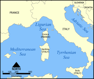
The Ligurian Sea is an arm of the Mediterranean Sea. It lies between the Italian Riviera (Liguria) and the island of Corsica. The sea is thought to have been named after the ancient Ligures people.

St Peter is one of the twelve parishes of Jersey in the Channel Islands. It is around 6.5 kilometres (4.0 mi) north-west of St Helier. The parish has a population of 5,003. It has a surface area of 10.6 square kilometres (4.1 sq mi).
Pedro Bank is a large bank of sand and coral, partially covered with seagrass, about 80 km south and southwest of Jamaica, rising steeply from a seabed of 800 metres depth. It slopes gently from the Pedro Cays to the west and north with depths from 13 to 30 metres. The total area of the bank within the 100-metre (328-foot) isobath measures 8,040 square kilometres. The area of a depth to 40 metres is triangular, 70 kilometres long east-west, and 43 kilometres wide. 2,400 square kilometres are less than 20 metres deep. With its islets, cays and rocks, a total land area of 270,000 m2 (2,906,256 sq ft), it is the location of one of the two offshore island groups of Jamaica, the other one being the Morant Cays. The bank is centered at 17°06′N78°20′W.
The Cadomian Orogeny was a tectonic event or series of events in the late Neoproterozoic, about 650–550 Ma, which probably included the formation of mountains. This occurred on the margin of the Gondwana continent, involving one or more collisions of island arcs and accretion of other material at a subduction zone. The precise events, and geographical position, are uncertain, but are thought to involve the terranes of Avalonia, Armorica and Iberia. Rocks deformed in the orogeny are found in several areas of Europe, including northern France, the English Midlands, southern Germany, Bohemia, southern Poland and the southwest Iberian Peninsula. The name comes from Cadomus, the Latin name for Caen, northern France. L Bertrand gave the orogeny its name in 1921, naming it after Cadomus the Gaulish name for Caen in Normandy. He defined the end as being marked by Lower Palaeozoic red beds.
Cotentinais is the dialect of the Norman language spoken in the Cotentin Peninsula of France. It is one of the strongest dialects of the language on the French mainland.

Auderville is a former commune on the north coast of the Manche department in the Normandy region in northwestern France. On 1 January 2017, it was merged into the new commune La Hague.

The River class was a class of fourteen destroyers of the Royal Canadian Navy (RCN) that served before and during the Second World War. They were named after Canadian rivers.

Barneville-Carteret is a commune in the Manche department in the Normandy region of north-western France. For many years it has been a popular seaside resort destination.
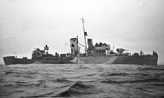
HMCS Kenogami was a Royal Canadian Navy Flower-class corvette that served during the Second World War. The corvette served primarily in convoy escort duties during the Battle of the Atlantic. Following the war, the ship was sold for scrap and broken up.
Evans Piedmont Glacier is a broad ice sheet occupying the low-lying coastal platform between Tripp Island and Cape Archer in Victoria Land, Antarctica.
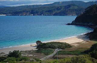
The Alderney Race is a strait that runs between Alderney and Cap de la Hague, a cape at the northwestern tip of the Cotentin Peninsula in Normandy. A strong current runs through the race north of the Passage de la Déroute, a treacherous passage separating the Cotentin from the Channel Islands. The current is intermittent, varying with the tide, and can run up to about 12 knots during equinoctial tides. The French call it Raz Blanchard. In Norman French it is called L'Raz.


![The La Hague lighthouse [fr] Phare La Hague1.jpg](http://upload.wikimedia.org/wikipedia/commons/thumb/4/4e/Phare_La_Hague1.jpg/220px-Phare_La_Hague1.jpg)