Related Research Articles

The Bald Knob National Wildlife Refuge is a 15,022 acres (60.79 km2) (2014) wildlife refuge located in White County, Arkansas about two miles south of the town of Bald Knob. The refuge is managed by the United States Fish and Wildlife Service. The refuge features large numbers of migratory waterfowl and bald eagles during the winter months.

The Kankakee River is a tributary of the Illinois River, approximately 133 miles (214 km) long, in the Central Corn Belt Plains of northwestern Indiana and northeastern Illinois in the United States. At one time, the river drained one of the largest wetlands in North America and furnished a significant portage between the Great Lakes and the Mississippi River. Significantly altered from its original channel, it flows through a primarily rural farming region of reclaimed cropland, south of Lake Michigan.

The Piney Woods is a temperate coniferous forest terrestrial ecoregion in the Southern United States covering 54,400 square miles (141,000 km2) of East Texas, southern Arkansas, western Louisiana, and southeastern Oklahoma. These coniferous forests are dominated by several species of pine as well as hardwoods including hickory and oak. Historically the most dense part of this forest region was the Big Thicket though the lumber industry dramatically reduced the forest concentration in this area and throughout the Piney Woods during the 19th and 20th centuries. The World Wide Fund for Nature considers the Piney Woods to be one of the critically endangered ecoregions of the United States. The United States Environmental Protection Agency (EPA) defines most of this ecoregion as the South Central Plains.

Missisquoi National Wildlife Refuge is a National Wildlife Refuge in the U.S. state of Vermont located on the eastern shore of Lake Champlain and the southern side of Missisquoi Bay. The refuge is in Franklin County in the northwest corner of the state near the International Boundary with Canada.
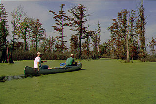
The Cache River is a 92-mile-long (148 km) waterway in southernmost Illinois, in a region sometimes called Little Egypt. The basin spans 737 square miles (1,910 km2) and six counties: Alexander, Johnson, Massac, Pope, Pulaski, and Union. Located at the convergence of four major physiographic regions, the river is part of the largest complex of wetlands in Illinois. The Cache River Wetlands is America's northernmost cypress/tupelo swamp and harbors 91 percent of the state's high quality swamp and wetland communities. It provides habitat for more than 100 threatened and endangered species in Illinois. In 1996, the Cache was designated a Wetland of International Importance by the Ramsar Convention.

The Chautauqua National Wildlife Refuge is located on the Illinois River in Mason County northeast of Havana, Illinois. It is managed by the U.S. Fish and Wildlife Service as one of the four Illinois River National Wildlife and Fish Refuges.
The Ray Norbut State Fish and Wildlife Area is a 1,140-acre (460 ha) state park located near Griggsville in Pike County, Illinois. It borders on the Illinois River and is primarily made of steeply sloped bluffland that is part of the river's valley. Heavily wooded, this region is managed for whitetail deer hunting. The Ray Norbut complex also includes Big Blue Island, a 100-acre (40 ha) riparian island in the Illinois River. The park is managed by the Illinois Department of Natural Resources (IDNR).
The Cypress Creek National Wildlife Refuge is an American wildlife refuge. It is located in the Cache River watershed in southernmost Illinois, largely in Pulaski County, but with extensions into Union, Alexander, and Johnson counties. The refuge was established in 1990 under the authority of the Emergency Wetlands Resources Act of 1986. The refuge protects over 16,000 acres (65 km2) of the Cache River wetlands, and has a purchase boundary of 36,000 acres (146 km²) contiguous.
The Iroquois County State Wildlife Area is an Illinois state park that occupies 2,480 acres (1,004 ha) in northeastern Iroquois County, near the border with Indiana. The nearest municipality is Beaverville, Illinois, and the nearest exit on a limited-access highway is Exit 302 on Interstate 57.
Marshall State Fish and Wildlife Area is an Illinois state park on 6,000 acres (2,400 ha) in Marshall County, Illinois, United States.
D'Arbonne National Wildlife Refuge is a National Wildlife Refuge of the United States located north of West Monroe, Louisiana. It is in Ouachita and Union Parishes on either side of Bayou D'Arbonne near its confluence with the Ouachita River. It lies on the western edge of the Mississippi River alluvial valley. It was established in 1975 to protect bottomland hardwoods and provide wintering habitat for migratory waterfowl. D'Arbonne is one of four refuges managed in the North Louisiana Refuges Complex.
Lake Ophelia National Wildlife Refuge was established in 1988 to protect the Mississippi/Red River floodplain ecosystem. The refuge is located in Avoyelles Parish, Louisiana, east central Louisiana. The refuge is named for its most prominent water body, the 350-acre (1.4 km2) Lake Ophelia that was at one time a channel of the nearby Red River of the South.
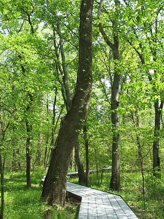
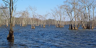
Bottomland forest is woodland on lowland alluvial floodplains or lower terraces of rivers and streams. Bottomland forest is very rare in Europe. The bottomland hardwood forest is a type of deciduous and evergreen hardwood forest found in broad lowland floodplains along large rivers and lakes in the United States and elsewhere. They are occasionally flooded, which builds up the alluvial soils required for the gum, oak and bald cypress trees that typically grow in this type of biome. The trees often develop unique characteristics to allow submergence, including cypress knees and fluted trunks, but can not survive continuous flooding.

Banner Marsh State Fish and Wildlife Area is an Illinois state park covering 4,363 acres (1,766 ha) in Fulton County, Illinois, United States.
Mathews Brake National Wildlife Refuge encompasses 2,418 acres (9.79 km2) in west-central Mississippi. Established in 1980, the refuge is one of seven national wildlife refuges in the Theodore Roosevelt National Wildlife Refuge Complex. The primary habitat feature is Mathews Brake, the largest brake in Leflore County. Each winter the brake provides habitat for over 30,000 ducks.

Roanoke River National Wildlife Refuge was established in 1989 to protect and enhance wooded wetlands consisting of bottomland hardwoods and swamps with high waterfowl value along the Roanoke River. The extensive bottomland hardwood habitat of the Roanoke River National Wildlife Refuge is part of what the Nature Conservancy calls "one of the last great places."
Spirit Creek Forest is a state forest in Richmond County, Georgia. The forest is 725 acres and is managed by the Georgia Forestry Commission. The forest is mostly made up of wetlands, loblolly pines, and bottomland hardwoods.
Pekin Lake State Fish and Wildlife Area is a 1,181-acre area of protected habitat on the Illinois River adjacent to the city of Pekin, Illinois within Tazewell County in the U.S. state of Illinois. The Illinois Department of Natural Resources (IDNR) describes the protected area as a bottomland of sloughs, lakes, and low timbered ridges.
The Swan Lake Wildlife Area is a 2,466 acres (998 ha) tract of protected land located in Columbia County, Wisconsin, managed by the Wisconsin Department of Natural Resources (WDNR). Land to be used for the wildlife area was first acquired in 1963 to provide for hunting and other outdoor recreational activities in the county. In addition to outdoor recreation activities, the wildlife area was established to protect the Fox River watershed.

The Avon Bottoms Wildlife Area is a tract of protected land located on the border of Illinois in Rock County, Wisconsin, managed by the Wisconsin Department of Natural Resources (WDNR).
References
- 1 2 "Cape Bend State Fish and Wildlife Area". dnr.illinois.gov. Illinois Department of Natural Resources. 2024. Retrieved May 23, 2024.
- ↑ "Cape Bend State Fish and Wildlife Area=". huntillinois.org. Hunt Illinois. Retrieved May 23, 2024.