
Ross Island is an island in Antarctica lying on the east side of McMurdo Sound and extending 43 nautical miles from Cape Bird on the north to Cape Armitage on the south, and a like distance from Cape Royds on the west to Cape Crozier on the east. The island is entirely volcanic. Mount Erebus, 3,795 metres (12,451 ft), near the center, is an active volcano. Mount Terror, 3,230 metres (10,600 ft), about 20 nautical miles eastward, is an extinct volcano. Mount Bird rises to 1,765 metres (5,791 ft) just south of Cape Bird. Ross Island lies within the boundary of Ross Dependency, an area of Antarctica claimed by New Zealand.

New Britain is the largest island in the Bismarck Archipelago, part of the Islands Region of Papua New Guinea. It is separated from New Guinea by a northwest corner of the Solomon Sea and from New Ireland by St. George's Channel. The main towns of New Britain are Rabaul/Kokopo and Kimbe. The island is roughly the size of Taiwan. When the island was part of German New Guinea, its name was Neupommern . In common with most of the Bismarcks it was largely formed by volcanic processes, and has active volcanoes including Ulawun, Langila, the Garbuna Group, the Sulu Range, and the volcanoes Tavurvur and Vulcan of the Rabaul caldera. A major eruption of Tavurvur in 1994 destroyed the East New Britain provincial capital of Rabaul. Most of the town still lies under metres of ash, and the capital has been moved to nearby Kokopo.
Borchgrevink Glacier is a large glacier in the Victory Mountains, Victoria Land, Antarctica. It drains south between Malta Plateau and Daniell Peninsula, and thence projects into Glacier Strait, Ross Sea, as a floating glacier tongue.
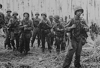
The New Britain campaign was a World War II campaign fought between Allied and Imperial Japanese forces. The campaign was initiated by the Allies in late 1943 as part of a major offensive which aimed to neutralise the important Japanese base at Rabaul, the capital of New Britain, and was conducted in two phases between December 1943 and the end of the war in August 1945.
Sulka is a language isolate of New Britain, Papua New Guinea. In 1991, there were 2,500 speakers in eastern Pomio District, East New Britain Province. Villages include Guma in East Pomio Rural LLG. With such a low population of speakers, this language is considered to be endangered. Sulka speakers had originally migrated to East New Britain from New Ireland.
The Tolai language, or Kuanua, is spoken by the Tolai people of Papua New Guinea, who live on the Gazelle Peninsula in East New Britain Province.
Lungalunga, frequently though ambiguously called Minigir, is spoken by a small number of the Tolai people of Papua New Guinea, who live on the Gazelle Peninsula in East New Britain Province. It is often referred to in the linguistics literature as the Tolai "dialect" with an.

The Gazelle Peninsula is a large peninsula in northeastern East New Britain, Papua New Guinea located on the island of New Britain within the Bismarck Archipelago, situated in the southwestern Pacific Ocean. The Rabaul caldera is located on the northern tip of the peninsula. Upon the Gazelle Peninsula are the Baining Mountains, of which the highest point is Mount Sinewit at 2,063 m (6,768 ft). The Gazelle Peninsula houses Vulcan Crater and Mount Tavurvur, both of which conducted volcanic activity in the 20th and 21st centuries and have provided extremely fertile soils. The body of the Gazelle Peninsula is about 80 km (50 mi). The southern isthmus upon which the Gazelle Peninsula is connected to the main body of East New Britain is reduced to about 32 km (20 mi).

Duke of York Island is the largest island of Duke of York Islands, Papua New Guinea, at 4.1666667°S 152.4666667°E. The island is named after Prince Frederick, the second son of King George III of Great Britain.
Zykov Glacier is a valley glacier about 25 nautical miles long in the Anare Mountains of Victoria Land, Antarctica. It flows northwest and reaches the coast between Cape Williams and Cooper Bluffs. It was photographed by the Soviet Antarctic Expedition (SovAE) in 1958 and named for student navigator Ye. Zykov, who died in Antarctica, Feb. 3, 1957.

Hut Point Peninsula is a long, narrow peninsula from 2 to 3 nautical miles wide and 15 nautical miles long, projecting south-west from the slopes of Mount Erebus on Ross Island, Antarctica. McMurdo Station (US) and Scott Base (NZ) are Antarctic research stations located on the Hut Point Peninsula.

The Adare Peninsula, is a high ice-covered peninsula, 40 nautical miles long, in the northeast part of Victoria Land, extending south from Cape Adare to Cape Roget. The peninsula was named by the New Zealand Antarctic Place-Names Committee (NZ-APC) for Cape Adare. The peninsula is considered the southernmost point of the Borchgrevink Coast, named for Carsten Borchgrevink (1864-1934).
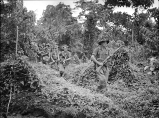
The Battle of Wide Bay–Open Bay was a battle during the New Britain campaign of the Second World War. Following the arrival of the Australians on New Britain in late 1944, replacing the US garrison on the island, they began a limited offensive against the Japanese forces on the island. Pushing east from the positions previously captured by the US troops earlier in the year, after landing at Jacquinot Bay on the southern coast in November, the Australians began advancing across the island towards the Gazelle Peninsula, where they sought to isolate the numerically superior Japanese garrison. This advance was effected along two axes: Cape Hoskins to Open Bay on the northern coast, and Jacquinot Bay to Wide Bay on the southern. Once the Australians had secured a line across the island between Wide Bay and Open Bay in March and April 1945, the fighting on New Britain died down as the Australians sought to contain the larger Japanese garrison while limiting their own casualties. This situation lasted until the end of the war in August 1945.

Cape Brett Peninsula is a 15 km (9.3 mi) long peninsula in the Bay of Islands, in the Northland Region of New Zealand.
Backdoor Bay is a small bay lying at the east side of Cape Royds, along the west side of Ross Island, Antarctica.

The Battle of Karavia Bay occurred in February 1944 and was the first surface engagement fought in the Rabaul area of New Britain during the Solomon Islands Campaign. A squadron of United States Navy warships attacked the harbor defenses of Karavia Bay and exchanged naval gunfire and torpedoes with two Japanese destroyers. The nighttime engagement ended with the silencing of the Japanese artillery and resulted in a blockade of the port. Two Japanese transports were also sunk in the fighting. Later, Allied forces landed on the island and destroyed the enemy garrison.

The Warangoi River also known as the Adler River, is a river located in the eastern part of the Gazelle Peninsula in the north-eastern part of New Britain, Papua New Guinea. It flows past the village of Warangoi and out into the Warangoi Bay. It played a part in the Battle of Rabaul early in 1942. Lieutenant Colonel Ishiro Kuwada's men of the 3rd Infantry Battalion captured at least 200 Australian men between the Warangoi River and Vunakanau. Virgin rainforest lies along the river basin.
Toma is a town located on the Gazelle Peninsula in East New Britain province, Papua New Guinea. It is located in Vunadidir-Toma Rural LLG.

West Haldon is a locality split between Toowoomba Region and Lockyer Valley Region in Queensland, Australia. In the 2021 census, West Haldon had a population of 63 people.

Emu Vale is a rural town and locality in the Southern Downs Region, Queensland, Australia. In the 2021 census, the locality of Emu Vale had a population of 161 people.