Cape Kane

Last updated
Cape Kane
Kap Kane
Operational Navigation Chart A-5, 3rd edition.jpg
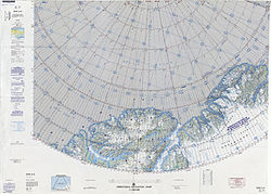
Map of part of Ellesmere Island and far Northern Greenland
Greenland edcp relief location map.jpg
Red pog.svg
Cape Kane
Coordinates: 83°29′N39°10′W / 83.483°N 39.167°W / 83.483; -39.167
Location Peary Land, Greenland
Offshore water bodies Conger Sound
Lincoln Sea
Hunt Fjord
Elevation650 m (2,130 ft) [1]

Cape Kane (Danish : Kap Kane) is a headland in North Greenland. Administratively it belongs to the Northeast Greenland National Park. [2]

Contents

Cape Kane was named after Arctic explorer Elisha Kent Kane (1820 – 1857) at the time that it was the nearest land to the North Pole that had been put on the map. [3]

Geography

Cape Kane is a rocky headland located 14.5 km (9.0 mi) west of Cape Washington, [4] northeast of Conger Sound and off the western side of the mouth of Hunt Fjord. [5] Hunt Fjord is under the influence of slow-moving glaciers discharging on both sides of Cape Kane that completely fill it and partially clog neighboring Conger Sound as well. [6]

Cape Kane is the westernmost point of the Roosevelt Land Peninsula. Cape Christiansen is the headland on the other side of Conger Sound, at the northern end of Lockwood Island. [4] [2]

See also

Related Research Articles

<span class="mw-page-title-main">Danmark Fjord</span>

Danmark Fjord, also known as Denmark Sound, is a fjord in northeast Greenland. Administratively it belongs to the Northeast Greenland National Park.

Lyell Land is a peninsula in King Christian X Land, East Greenland. It is located in the King Oscar Fjord area. Administratively it is part of the Northeast Greenland National Park zone.

Payer Peak, is a mountain in King Christian X Land, Northeast Greenland. Administratively it is part of the Northeast Greenland National Park zone.

<span class="mw-page-title-main">Odinland</span> Peninsula in southeastern Greenland

Odinland, also Odinsland in the Defense Mapping Agency Greenland Navigation charts, is a peninsula in the King Frederick VI Coast, southeastern Greenland. It is a part of the Sermersooq municipality.

<span class="mw-page-title-main">Academy Glacier (Greenland)</span> Glacier in Greenland

Academy Glacier, is one of the major glaciers in northern Greenland.

Washington Land is a peninsula in northwestern Greenland. It is a part of the Avannaata municipality.

Sherard Osborn Fjord is a fjord in northern Greenland. To the NNW, the fjord opens into the Lincoln Sea. Administratively it is part of the Northeast Greenland National Park.

<span class="mw-page-title-main">Weyprecht Fjord</span>

Weyprecht Fjord is a fjord in Peary Land, northern Greenland. To the northwest, the fjord opens into the Lincoln Sea of the Arctic Ocean. It is part of the Northeast Greenland National Park.

<span class="mw-page-title-main">Sands Fjord</span> Fjord in northern Greenland

Sands Fjord is a fjord in Peary Land, northern Greenland. To the north, the fjord opens into the Lincoln Sea of the Arctic Ocean. Administratively, it belongs to the Northeast Greenland National Park.

<span class="mw-page-title-main">Lockwood Island</span>

Lockwood Island is an island of the Lincoln Sea, Greenland. Administratively it belongs to the Northeast Greenland National Park.

<span class="mw-page-title-main">Hunt Fjord</span> Fjord in Peary Land, Greenland

Hunt Fjord is a fjord in Peary Land, northern Greenland. To the north the fjord has its mouth in the Lincoln Sea of the Arctic Ocean. Administratively it belongs to the Northeast Greenland National Park.

<span class="mw-page-title-main">Cape Washington, Greenland</span>

Cape Washington is a headland in North Greenland. Administratively it belongs to the Northeast Greenland National Park.

<span class="mw-page-title-main">Nordvestfjord</span> Fjord in Greenland

Nordvestfjord, meaning 'Northwest Fjord', is a fjord in King Christian X Land, eastern Greenland.

<span class="mw-page-title-main">Johannes V. Jensen Land</span> Region in Northeast Greenland National Park, Greenland

Johannes V. Jensen Land is an area in Peary Land, Northern Greenland. Administratively it lies in the Northeast Greenland National Park zone. The area is remote and currently uninhabited.

<span class="mw-page-title-main">Geologfjord</span>

Geologfjord is a fjord in King Christian X Land, East Greenland. Administratively it belongs to the Northeast Greenland National Park.

<span class="mw-page-title-main">Cape Harald Moltke</span>

Cape Harald Moltke is a headland in Peary Land, North Greenland. Administratively it is part of the Northeast Greenland National Park.

<span class="mw-page-title-main">Nansen Land</span> Peninsula of Greenland

Nansen Land is a peninsula in far northwestern Greenland. It is a part of the Northeast Greenland National Park.

<span class="mw-page-title-main">Roosevelt Land</span>

Roosevelt Land is a peninsula in far northern Greenland. It is a part of the Northeast Greenland National Park.

<span class="mw-page-title-main">Cape Christiansen</span> Headland in Greenland

Cape Christiansen is a headland in North Greenland. Administratively it belongs to the Northeast Greenland National Park.

<span class="mw-page-title-main">Conger Sound</span>

Conger Sound, also known as Conger Inlet, is a fjord in Peary Land, far northern Greenland.

References