Cape Christiansen Kap Christiansen | |
|---|---|
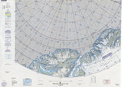 Map of part of Ellesmere Island and far Northern Greenland | |
 Cape Christiansen | |
| Coordinates: 83°25′N39°40′W / 83.417°N 39.667°W | |
| Location | Peary Land, Greenland |
| Offshore water bodies | Conger Sound Lincoln Sea Weyprecht Fjord |
Cape Christiansen (Danish : Kap Christiansen) is a headland in North Greenland. Administratively it belongs to the Northeast Greenland National Park. [1]
Contents
Cape Christiansen was named after Frederick Thorlip Christiansen (1846 – 1884), Inughuit dogsled driver and guide of the Lady Franklin Bay Expedition who died of starvation on April 5, 1884 at Camp Clay. [2]