Cape Lutke (Alaska)

Last updated
Cape Lutkes headland Cape Promontory Cape Lutkes, Alaska. Cape Lutkes is part of the Aleutian Islands.JPG
Cape Lutkes headland

Cape Lutke is a headland on Unimak Island, the largest island in the Aleutian Islands chain of the U.S. state of Alaska. It is located on the southern central coast of the island.

Unimak Island island in the United States of America

Unimak Island is the largest island in the Aleutian Islands chain of the U.S. state of Alaska.

Island Any piece of sub-continental land that is surrounded by water

An island or isle is any piece of sub-continental land that is surrounded by water. Very small islands such as emergent land features on atolls can be called islets, skerries, cays or keys. An island in a river or a lake island may be called an eyot or ait, and a small island off the coast may be called a holm. A grouping of geographically or geologically related islands is called an archipelago, such as the Philippines.

Aleutian Islands chain of islands in the Northern Pacific

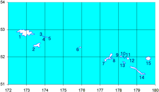
The Aleutian Islands, also called the Aleut Islands or Aleutic Islands and known before 1867 as the Catherine Archipelago, are a chain of 14 large volcanic islands and 55 smaller ones belonging to both the U.S. state of Alaska and the Russian federal subject of Kamchatka Krai. They form part of the Aleutian Arc in the Northern Pacific Ocean, occupying an area of 6,821 sq mi (17,666 km2) and extending about 1,200 mi (1,900 km) westward from the Alaska Peninsula toward the Kamchatka Peninsula in Russia, and mark a dividing line between the Bering Sea to the north and the Pacific Ocean to the south. Crossing longitude 180°, at which point east and west longitude end, the archipelago contains both the westernmost part of the United States by longitude and the easternmost by longitude. The westernmost U.S. island in real terms, however, is Attu Island, west of which runs the International Date Line. While nearly all the archipelago is part of Alaska and is usually considered as being in the "Alaskan Bush", at the extreme western end, the small, geologically related Commander Islands belong to Russia.

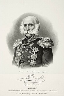
This headland was named Mys Litke, after Russian explorer Count Fyodor Petrovich Litke, by the Imperial Russian Hydrographic Service in 1847. "Litke" is the Russian form of the German "Lütke", which is Anglicized as "Lutke". [1]

Russian Hydrographic Service organization

The Russian Hydrographic Service, full current official name Department of Navigation and Oceanography of the Ministry of Defence of the Russian Federation, is Russia's hydrographic office, with responsibility to facilitate navigation, performing hydrographic surveys and publishing nautical charts.

This same point was called Mys Sivuchiy (meaning "Sealion Cape" in Russian) by Capt. Tebenkov in 1852, and Cape Promontory by the U.S. Bureau of Fisheries (USBF) in 1888.

United States Fish and Wildlife Service US Federal Government agency

The United States Fish and Wildlife Service is an agency of the US Federal Government within the US Department of the Interior dedicated to the management of fish, wildlife, and natural habitats. The mission of the agency is "working with others to conserve, protect, and enhance fish, wildlife, plants and their habitats for the continuing benefit of the American people."

Related Research Articles

Friedrich von Lütke Russian admiral

Friedrich Benjamin Graf von Lütke, more commonly known by his Russian name Fyodor Litke, was a Baltic German navigator, geographer, and Arctic explorer. He became a count in 1866, and an admiral in 1855. He was a corresponding member (1829), Honorable Member (1855), and President (1864) of the Russian Academy of Science in St. Petersburg. He was also an Honorable Member of many other Russian and foreign scientific establishments, and a corresponding member of the French Academy of Science in Paris.

Rat Islands island group

The Rat Islands are a volcanic group of islands in the Aleutian Islands in southwest Alaska, between Buldir Island and the Near Islands group to its west, and Amchitka Pass and the Andreanof Islands group to its east, at about 51°47′17″N178°18′10″E.

Cape Pankof and Pankov Rock are located on Unimak Island in the Aleutian Islands in the U.S. state of Alaska, at 54°39′31″N163°04′11″W and 54°42′N163°0′W respectively. They were named by Russian explorer Gavril Sarychev after the Aleut Toien (Chief) Sergey Pan'kov in 1791.

Delarof Islands island group

The Delarof Islands are a group of small islands at the extreme western end of the Andreanof Islands group in the central Aleutian Islands, Alaska. The Delarofs consist of 11 named islands: Amatignak, Gareloi, Ilak, Kavalga (Qavalĝa), Ogliuga (Aglaga), Skagul (Sxaĝulax̂), the Tags (Tagachaluĝis), Tanadak (Tanaadax̂), Ugidak (Qagan-tanax̂), Ulak, and Unalga (Unalĝa).

Round Island is a 0.1-mile-wide (160 m) island in the Krenitzin Islands, a subgroup of the Fox Islands group of the Aleutian Islands in the U.S. state of Alaska. It is located 0.5 miles (800 m) south of Ugamak Island at 54°11′58″N164°46′33″W.

Aiktak Island island in the United States of America

Aiktak Island is one of the Krenitzin Islands, a subgroup of the Fox Islands in the eastern Aleutian Islands in the U.S. state of Alaska. It is 1.3 miles (2.1 km) long and is located 38 miles (61 km) east of Akutan Island. Aiktak is an Aleut name transcribed by Captain Tebenkov in 1852 as "Ostrov Aikhtak." R. H. Geoghegan suggested that the name is derived from the Aleut "aikhag", meaning "travel or going on a voyage." It is also known as Ashmiak.

Avatanak Island island in the United States of America

Avatanak Island is the second-largest of the Krenitzin Islands, a subgroup of the Fox Islands in the eastern Aleutian Islands in the U.S. state of Alaska. It lies southeast of Akun Island, across the Avatanak Strait. Within the Krenitzin Islands, it lies between Rootok Island (Aayux̂tax̂) to the west, and Tigalda Island to the east.

Tigalda Island island in the United States of America

Tigalda Island is one of the Krenitzin Islands, a subgroup of the Fox Islands in the eastern Aleutian Islands, Alaska. Tigalda is located about 19 miles (31 km) east of Akutan Island, is 12 miles (19 km) long and has an area of about 35 square miles (91 km2). Tigalda is an Aleut name published by Captain Lutke (1836). It was called "Kagalga" by Captain Lt. Krenitzin and Lt. Levashev (1768). Tigalda Bay is situated on the north side of Tigalda. Father Veniaminov (1840) reported the existence of an Aleut village, which he called "Tigaldinskoe", of 91 people in 1833. Tigalda is uninhabited.

Wislow Island island in the United States of America

Wislow Island is an island in the Fox Islands group of the eastern Aleutian Islands in the U.S. state of Alaska. It is 520 feet (160 m) across and situated in Reese Bay midway between Capes Wislow and Cheerful on the north coast of Unalaska Island, 11.3 miles (18.2 km) northwest of Dutch Harbor. It was named in 1888 by the U.S. Bureau of Fisheries.

Nansen Island (Franz Josef Land) island in Russia

Nansen Island is an island in Franz Josef Land, Russia. The island is partly glaciated and its area is 164 km2 (63 sq mi). The highest point of the island is 372 m (1,220 ft).

Kudobin Islands a group of small islands in the Bering Sea

The Kudobin Islands are a group of small islands in the Bering Sea, near the coast of Alaska, 13 miles (21 km) West of Port Moller; Bristol Bay Low. The group includes a cluster of other small coastal islands, Walrus and Kritskoi Islands, forming a geographical whole.

Cape Chaplino

Cape Chaplin or Cape Chaplino is a cape pointing eastward in the Bering Sea in the Chukotka Autonomous Okrug of the Russian Federation.

Mikhail Nikolayevich Vasilyev was a Russian explorer and vice admiral of the Imperial Russian Navy. He is reputed for having surveyed the then little-known coast of Alaska as navigator. Vasiliev was sent by the Russian Imperial Hydrographic Service in 1819 to explore the northern parts of the Pacific Ocean and particularly the area around the Bering Strait. Certain geographic features of the Alaskan coast, like the Lindenberg Peninsula and Sealion Island were named by him in the maps that were subsequently published.

Cape Thompson is a headland on the Chukchi Sea coast of Alaska. It is located 26 miles to the southeast of Point Hope, Arctic Slope. It is part of the Chukchi Sea unit of Alaska Maritime National Wildlife Refuge.

Point Hope (cape) cape in Alaska, United States

Point Hope is a headland in the U.S. state of Alaska, located at the western tip of the Lisburne Peninsula. It lies on the Chukchi Sea coast, 40 miles southwest of Cape Lisburne, Arctic Slope at 68°20′27″N166°50′00″W. The city of Point Hope is located on the foreland.

Cape Schmidt

Cape Schmidt is a headland in the Chukchi Sea, part of Iultinsky District of the Chukotka Autonomous Okrug, Russian Federation.

Cape Muzon

Cape Muzon is a cape located in the Alexander Archipelago of the U.S. state of Alaska. It is the southernmost point of Dall Island and the headland marking the northwestern extremity of the Dixon Entrance. The boundary line separating Alaska from Canada runs very close to Cape Muzon, although according to the Alaska Boundary Treaty Cape Muzon is defined precisely as the western end of the so-called A-B Line, part of the Canada–United States border.

References

Coordinates: 54°29′02″N164°20′59″W / 54.48389°N 164.34972°W / 54.48389; -164.34972

Geographic coordinate system Coordinate system

A geographic coordinate system is a coordinate system that enables every location on Earth to be specified by a set of numbers, letters or symbols. The coordinates are often chosen such that one of the numbers represents a vertical position and two or three of the numbers represent a horizontal position; alternatively, a geographic position may be expressed in a combined three-dimensional Cartesian vector. A common choice of coordinates is latitude, longitude and elevation. To specify a location on a plane requires a map projection.