Cape Mary Harmsworth

Last updated

Coordinates: 80°35′58″N44°54′45″E / 80.59944°N 44.91250°E / 80.59944; 44.91250

Geographic coordinate system Coordinate system

A geographic coordinate system is a coordinate system that enables every location on Earth to be specified by a set of numbers, letters or symbols. The coordinates are often chosen such that one of the numbers represents a vertical position and two or three of the numbers represent a horizontal position; alternatively, a geographic position may be expressed in a combined three-dimensional Cartesian vector. A common choice of coordinates is latitude, longitude and elevation. To specify a location on a plane requires a map projection.

Location of Alexandra Land in the Franz Josef Archipelago. Cape Mary Harmsworth is located on its western end. Kara sea ZFJAL.PNG
Location of Alexandra Land in the Franz Josef Archipelago. Cape Mary Harmsworth is located on its western end.

Cape Mary Harmsworth (Russian: Мыс Мэри-Хармсуорт; Mys Meri Kharmsuort) is a cape located in Alexandra Land (Russian Federation).

Alexandra Land island

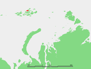
Alexandra Land is a large island located in Franz Josef Land, Arkhangelsk Oblast, Russian Federation. Not counting detached and far-lying Victoria Island, it is the westernmost island of the Franz Josef Archipelago. It is the site of a Russian military base that was reopened in 2017.

This cape is the westernmost point of the Franz Josef Archipelago proper, not counting far-lying Victoria Island which is geographically detached from the group.

Franz Josef Land archipelago in the Arctic

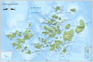
Franz Josef Land, Franz Joseph Land or Francis Joseph's Land is a Russian archipelago, inhabited only by military personnel, located in the Arctic Ocean and constituting the northernmost part of Arkhangelsk Oblast. It consists of 191 islands, which cover an area of 16,134 square kilometers (6,229 sq mi), stretching 375 kilometers (233 mi) from east to west and 234 kilometers (145 mi) from north to south. The islands are categorized in three groups, a western, central and eastern, separated by the British Channel and the Austrian Strait. The central group is further divided into a northern and southern section by the Markham Strait. The largest island is Prince George Land, which measures 2,741 square kilometers (1,058 sq mi), followed by Wilczek Land, Graham Bell Island and Alexandra Land.

Cape Mary Harmsworth was named after Alfred Harmsworth' s wife Mary. Alfred Harmsworth, fellow of the Royal Geographical Society, was the main sponsor of the 1894 Jackson-Harmsworth Polar Expedition to Franz Joseph Land.

Royal Geographical Society British learned society

The Royal Geographical Society is the UK's learned society and professional body for geography, founded in 1830 for the advancement of geographical sciences. Today, it is the leading centre for geographers and geographical learning. The Society has over 16,500 members and its work reaches millions of people each year through publications, research groups and lectures.

Frederick George Jackson British polar explorer

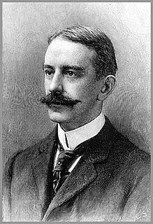
Frederick George Jackson was an English Arctic explorer remembered for his expedition to Franz Josef Land, when he located the missing Norwegian explorer Fridtjof Nansen.

This is the place that Russian navigator Valerian Albanov of the Svyataya Anna reached in 1914 after his long and tragic ordeal on the Polar ice.

Valerian Albanov navigator

Valerian Ivanovich Albanov was a Russian navigator, best known for being one of two survivors of the Brusilov Expedition of 1912, which killed 22.

<i>Svyataya Anna</i>

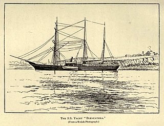
The Philomel-class gunvesselHMS Newport was launched in England in 1867. Having become the first ship to pass through the Suez Canal, she was sold in 1881 and renamed Pandora II. She was purchased again in about 1890 and renamed Blencathra, taking part in expeditions to the north coast of Russia. She was bought in 1912 by Georgy Brusilov for use in his ill-fated 1912 Arctic expedition to explore the Northern Sea Route, and was named Svyataya Anna, after Saint Anne. The ship became firmly trapped in ice; only two members of the expedition, Valerian Albanov and Alexander Konrad, survived. The ship has never been found.

Related Research Articles

Kara Sea A marginal sea of the Arctic Ocean north of Siberia between Novaya Zemlya and Severnaya Zemlya

The Kara Sea is part of the Arctic Ocean north of Siberia. It is separated from the Barents Sea to the west by the Kara Strait and Novaya Zemlya, and the Laptev Sea to the east by the Severnaya Zemlya archipelago. It is named after the Kara River, which is now relatively insignificant but which played an important role in the Russian conquest of northern Siberia. The Kara River name is derived from Nenets word meaning "hummocked ice".

Georgy Sedov Russian Arctic explorer

Georgy Yakovlevich Sedov was a Russian Arctic explorer.

Northbrook Island island

Northbrook Island is an island located at 79.9°N 50.9°E in the southern edge of the Franz Josef Archipelago, Russia. Its highest point is 344 m.

Hooker Island island

Hooker Island is one of the central islands of Franz Josef Land. It is located in the central area of the archipelago at 80.23°N 53.02°E. It is administered by the Arkhangelsk Oblast, Russia.

Jackson Island island in Russia

Jackson Island is an island located in Franz Josef Land, Arkhangelsk Oblast, Russian Federation. This island is part of the Zichy Land subgroup of the central part of the archipelago.

Georgy Brusilov Russian explorer and navy officer

Georgy Lvovich Brusilov or Hryhoriy Brusylov was a Russian naval officer of the Imperial Russian Navy and an Arctic explorer. His father, Lev Brusilov, was also a naval officer.

Nansen Island (Franz Josef Land) island in Russia

Nansen Island is an island in Franz Josef Land, Russia. The island is partly glaciated and its area is 164 km2 (63 sq mi). The highest point of the island is 372 m (1,220 ft).

Arthur Island island in Russia

Arthur Island is an island in Franz Josef Land, Russia. It belongs administratively to the Arkhangelsk Oblast of the Russian Federation.

Vize Island island

Vize Island or Wiese Island, also known as Zemlya Vize is an isolated Russian island located in the Arctic Ocean.

Eva-Liv Island island

Eva-Liv Island, also known as Eva Island, is the northeasternmost island in Franz Josef Land, Arkhangelsk Oblast, Russian Arctic.

Alexander Konrad Russian explorer

Alexander Eduardovich Konrad was a Russian sailor. Along with Valerian Albanov, he was one of two survivors, and the only surviving sailor, of the Brusilov expedition in which 22 people lost their lives.

Belaya Zemlya island in Russia

Belaya Zemlya is a group of three cold, glaciated islands. It is a geographical subgroup of Franz Josef Land, Russian Federation.

Jackson–Harmsworth expedition

The Jackson–Harmsworth expedition of 1894–1897 to Franz Josef Land was led by British Arctic explorer Frederick George Jackson and financed by newspaper proprietor Alfred Harmsworth. Jackson had been misled by false maps into believing that Franz Joseph Land was a land mass that extended to the North Pole. The survey which was the main work of the expedition eventually proved that the land was in fact an archipelago, whose northernmost island stretched no further than 81° N.

Brusilov Expedition

The Brusilov Expedition was a Russian maritime expedition to the Arctic led by Captain Georgy Brusilov, which set out in 1912 to explore and map a route from the Atlantic Ocean to the Pacific via a northeast passage known as the Northern Sea Route. The expedition was ill-planned and ill-executed by Brusilov, and disappeared without a trace. Earlier searches were unsuccessful, and the fate of the ship and its crew is still not known.

Reginald Koettlitz British explorer

Reginald Koettlitz (1860–1916) was a British physician and polar explorer. He participated in the Jackson–Harmsworth expedition to Franz Josef Land and in the Discovery Expedition to Antarctica.

Geography of Franz Josef Land

The Geography of Franz Josef Land refers to an island group belonging to Arkhangelsk Oblast of Russia. It is situated in the Barents Sea of the Arctic, north of Novaya Zemlya and east of Svalbard. At latitudes between 80.0° and 81.9° north, it is the most northerly group of islands associated with Eurasia. The extreme northernmost point is Cape Fligely on Rudolf Island. The archipelago consists of 191 ice-covered islands with a total area of 16,134 km2 (6,229 sq mi). It is currently uninhabited. The archipelago is only 900 to 1,110 km from the North Pole, and the northernmost islands are closer to the Pole than any other land except for Canada's Ellesmere Island and Greenland. The largest island is Zemlya Georga which measures 110 km (68 mi) from end to end. The highest point in the archipelago is on Ostrov Viner-Neyshtadt which reaches 620 m (2,034 ft) above sea level. The central cluster of large islands in the midst of the archipelago forms a compact whole, known as Zichy Land, where islands are separated from each other by very narrow sounds that are frozen most of the year.

History of Franz Josef Land

Franz Josef Land, an uninhabited archipelago located in the Arctic Ocean, Barents Sea and Kara Sea, may have been discovered by the 1865 expedition of the Norwegian sealing vessel Spidsbergen captained by Nils Fredrik Rønnbeck. However, the discovery was never announced and the existence of the territory only came to public notice following the Austro-Hungarian North Pole Expedition of 1872, which named the archipelago in honor of Franz Joseph I of Austria. Benjamin Leigh Smith led the next expedition in 1880, which continued the work of the first expeditions in investigating the southern and central parts of the archipelago. Concurrent expeditions followed in 1896, Nansen's Fram expedition and the Jackson–Harmsworth Expedition, which met by accident. These two journeys explored the northern area and the flanks of Franz Josef Land.

References