Zichy Land

Last updated • 1 min readFrom Wikipedia, The Free Encyclopedia
Zichy Land
Земля Зичи
Map of central Franz Josef Land-en.svg
Zichy Land islands to the south of Rudolf Island.
Kara sea ZFJZL.PNG
Location of the Zichy Land subgroup of the Franz Josef Archipelago.
Geography
Location Arctic
Coordinates 81°00′N56°00′E / 81.000°N 56.000°E / 81.000; 56.000
Archipelago Franz Josef Archipelago
Total islands22
Major islands Salisbury Island, Jackson Island
Highest elevation620 m (2030 ft)
Highest point Peak Parnass
Administration
Demographics
Population0
Zemlya Zichy in the central position of Franz Josef Land in the corner of a ca 1902 Yeniseysk Governorate map. Yenisey gub - section - Franz Josef Land.jpg
Zemlya Zichy in the central position of Franz Josef Land in the corner of a ca 1902 Yeniseysk Governorate map.

Zichy Land (Russian : Земля Зичи; Zemlya Zichy) is a geographical subgroup of Franz Josef Land, Arkhangelsk Oblast, Russia. It is formed by the central cluster of large islands in the midst of the archipelago. The islands are separated from each other by narrow sounds that are frozen most of the year, forming a compact whole. [1]

Contents

This island group was named after Hungarian Count Ödön Zichy (1811-1894) [2] who was, beside Count Johann Nepomuk Wilczek, the second highest sponsor for the Austro-Hungarian North Pole Expedition to Franz Josef Land.[ citation needed ]

Geography

The broad channel to the southwest of Zichy Land is known as Markham Sound or Markham Channel (Russian : Пролив маркама; Proliv Markama), after the British polar explorer Admiral Sir Albert Hastings Markham.[ citation needed ]

The northernmost point of Zichy Land is Cape Bema on Karl-Alexander Island and its southernmost point is Cape Fiume on Champ Island. The distance between the two comprises 114 kilometres (71 miles). Cape Armitidzh in Luigi Island is the westernmost point of the subgroup. The highest point is 620 metres (2,034 feet) high Peak Parnass located on Wiener Neustadt Island. [3] The channels separating the islands in the southeastern area of the group are very narrow.

Zichy Land in an 1874 Franz Josef Land map by Julius Payer. Payer map Franz Josef Land 1874.jpg
Zichy Land in an 1874 Franz Josef Land map by Julius Payer.
Zichy Land in an 1898 map of Frederick G. Jackson's explorations showing already separate islands. Map of Franz Josef Land showing journeys and discoveries of Frederick G. Jackson, F.R.G.S. - UvA-BC OTM HB-KZL 61 18 38.jpg
Zichy Land in an 1898 map of Frederick G. Jackson's explorations showing already separate islands.

Islands

The individual islands forming the Zemlya Zichy archipelago are (from North to south):

See also

Related Research Articles

<span class="mw-page-title-main">Austro-Hungarian North Pole expedition</span> 1872-74 Arctic expedition to find the North-East Passage

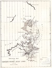
The Austro-Hungarian North Pole expedition was an Arctic expedition to find the North-East Passage that ran from 1872 to 1874 under the leadership of Julius Payer and Karl Weyprecht. The expedition discovered and partially explored Franz Josef Land.

<span class="mw-page-title-main">Franz Josef Land</span> Archipelago in the Arctic

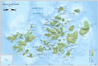
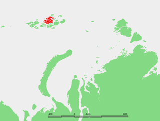
Franz Josef Land is a Russian archipelago in the Arctic Ocean. It is inhabited only by military personnel. It constitutes the northernmost part of Arkhangelsk Oblast and consists of 192 islands, which cover an area of 16,134 square kilometers (6,229 sq mi), stretching 375 kilometers (233 mi) from east to west and 234 kilometers (145 mi) from north to south. The islands are categorized in three groups separated by the British Channel and the Austrian Strait. The central group is further divided into a northern and southern section by the Markham Sound. The largest island is Prince George Land, which measures 2,741 square kilometers (1,058 sq mi), followed by Wilczek Land, Graham Bell Island and Alexandra Land.

<span class="mw-page-title-main">Zemlya Georga</span> Island in the Russian Arctic

Zemlya Georga, or Prince George Land, is the largest island in Franz Josef Land, Arkhangelsk Oblast, Russian Arctic.

<span class="mw-page-title-main">Graham Bell Island</span> Island in Franz Josef archipelago

Graham Bell Island is an island in the Franz Josef Archipelago in the Arctic Ocean, and is administratively part of Arkhangelsk Oblast, Russia.

<span class="mw-page-title-main">Jackson Island</span> Island in Russia

Jackson Island is an island located in Franz Josef Land, Arkhangelsk Oblast, Russian Federation. This island is part of the Zichy Land subgroup of the central part of the archipelago.

<span class="mw-page-title-main">Wilczek Land</span> Island in the Arctic Ocean

Wilczek Land, is an island in the Arctic Ocean at 80.58°N 60.5°E. At 2,000 km2 (770 sq mi) it is the second-largest island in Franz Josef Land, in Arctic Russia.

<span class="mw-page-title-main">Alexandra Land</span> Island in Franz Josef Land, Russia

Alexandra Land is a large island located in Franz Josef Land, Arkhangelsk Oblast, Russia. Not counting detached and far-lying Victoria Island, it is the westernmost island of Franz Josef Land. It is the site of a Russian military base that was reopened in 2017.

<span class="mw-page-title-main">Hall Island (Arctic)</span> Island of the Russian Arctic archipelago

Hall Island is an island of the Russian Arctic archipelago of Franz Josef Land.

<span class="mw-page-title-main">Salisbury Island (Russia)</span> Island located in central area of Franz Josef Land, Russia

Salisbury Island, is an island located in the central area of Franz Josef Land, Russia.

<span class="mw-page-title-main">Ziegler Island</span> Island in Franz Josef Land, Russia

Ziegler Island is an island in Franz Josef Land, Russia.

<span class="mw-page-title-main">Champ Island</span> Island in Franz Josef Land, Russia

Champ Island The highest point of the island is 507 meters above sea level. The area is 374 km². It is the southernmost island of the Zichy group of islands. Administratively located in the Primorsky district of Franz Josef Land, Russia.

<span class="mw-page-title-main">Luigi Island</span> Island in Franz Josef Land, northern Russia

Luigi Island is an island in Franz Josef Land, Russian Federation.

<span class="mw-page-title-main">Karl-Alexander Island</span> Island in Franz Josef Land, Russia

Karl Alexander Island, also known as Zemlya Karla-Alexandra, is an island in Franz Josef Land, Russia.

<span class="mw-page-title-main">Wiener Neustadt Island</span> Island in Franz Josef Land, Russian Federation

Wiener Neustadt Island is an island in Franz Josef Land, Russia.

<span class="mw-page-title-main">Nansen Island (Franz Josef Land)</span> Island in Russia

Nansen Island is an island in Franz Josef Land, Russia. The island is partly glaciated and its area is 164 km2 (63 sq mi). The highest point of the island is 372 m (1,220 ft).

<span class="mw-page-title-main">Rainer Island</span> Island in Franz Josef Land, Russia

Rainer Island or Rainier Island is an island in Franz Josef Land, Russia. Lat. 81° 42' N; long 59° 00' E.

<span class="mw-page-title-main">Hayes Island</span> Island in Franz Josef Land, Russia

Hayes Island, also known as Heiss Island is an island in Franz Josef Land, Russia. It is located in the central area of the archipelago, north of Hall Island, between Champ Island and Wilczek Land. Its area is 132 km2.

<span class="mw-page-title-main">Greely Island</span> Island in Franz Josef Land, Arkhangelsk Oblast, Russia

Greely Island is an island in Franz Josef Land, Arkhangelsk Oblast, Russia.

<span class="mw-page-title-main">Geography of Franz Josef Land</span>

The Geography of Franz Josef Land refers to an island group belonging to Arkhangelsk Oblast of Russia. It is situated in the Barents Sea of the Arctic, north of Novaya Zemlya and east of Svalbard. At latitudes between 80.0° and 81.9° north, it is the most northerly group of islands associated with Eurasia. The extreme northernmost point is Cape Fligely on Rudolf Island. The archipelago consists of 191 ice-covered islands with a total area of 16,134 km2 (6,229 sq mi). It is currently uninhabited. The archipelago is only 900 to 1,110 km from the North Pole, and the northernmost islands are closer to the Pole than any other land except for Canada's Ellesmere Island and Greenland. The largest island is Zemlya Georga which measures 110 km (68 mi) from end to end. The highest point in the archipelago is on Ostrov Viner-Neyshtadt which reaches 620 m (2,034 ft) above sea level. The central cluster of large islands in the midst of the archipelago forms a compact whole, known as Zichy Land, where islands are separated from each other by very narrow sounds that are frozen most of the year.

<span class="mw-page-title-main">Harley Island</span>

Harley Island is an island located in Franz Josef Land, Arkhangelsk Oblast, Russian Federation. This island is part of the Zichy Land subgroup of the central part of the archipelago.

References