
The Arctic Cape is a headland in Severnaya Zemlya, Russia.

Zemlya Georga, or Prince George Land, is the largest island in Franz Josef Land, Arkhangelsk Oblast, Russian Arctic.

Cape Fligely, is located on the northern shores of Rudolf Island and Franz Josef Land in the Russian Federation, and is the northernmost point of Russia, Europe, and Eurasia as a whole. It is 911 kilometres (566 mi) south from the North Pole.
Northbrook Island is an island located in the southern edge of the Franz Josef Archipelago, Russia. Its highest point is 344 m above sea level.

Hooker Island is one of the central islands of Franz Josef Land. It is located in the central area of the archipelago at 80.23°N 53.02°E. It is administered by the Arkhangelsk Oblast, Russia.
Jackson Island is an island located in Franz Josef Land, Arkhangelsk Oblast, Russian Federation. This island is part of the Zichy Land subgroup of the central part of the archipelago.

Alexandra Land is a large island located in Franz Josef Land, Arkhangelsk Oblast, Russian Federation. Not counting detached and far-lying Victoria Island, it is the westernmost island of the Franz Josef Archipelago. It is the site of a Russian military base that was reopened in 2017.

MacKlintok Island or McClintock Island is an island in Franz Josef Land, Russia.
Ziegler Island is an island in Franz Josef Land, Russia.

Champ Island The highest point of the island is 507 meters above sea level. The area is 374 km². It is the southernmost island of the Zichy group of islands. Administratively located in the Primorsky district of Franz Josef Land, Russia.
Bruce Island is an island in Franz Josef Land, Russia. Its area is 191 square kilometres (74 sq mi). The highest point of the island is 301 metres (988 ft).

Nansen Island is an island in Franz Josef Land, Russia. The island is partly glaciated and its area is 164 km2 (63 sq mi). The highest point of the island is 372 m (1,220 ft).

Heiss Island is an island in Franz Josef Land, Russia. It is located in the central area of the archipelago, north of Hall Island, between Champ Island and Wilczek Land. Its area is 132 km2.
Eva-Liv Island, alternatively transcribed as Yeva-Liv Island, and also known as Eva Island, is the northeasternmost island in Franz Josef Land, Arkhangelsk Oblast, Russian Arctic.

Benjamin Leigh Smith was an English Arctic explorer and yachtsman. He is the grandson of the Radical abolitionist William Smith.

Zichy Land is a geographical subgroup of Franz Josef Land, Arkhangelsk Oblast, Russia. It is formed by the central cluster of large islands in the midst of the archipelago. The islands are separated from each other by narrow sounds that are frozen most of the year, forming a compact whole.

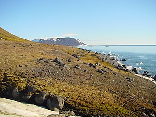
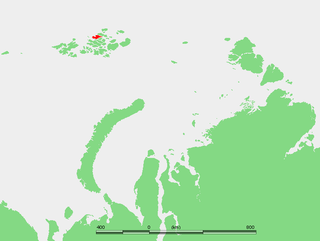
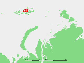
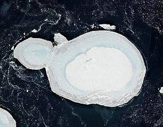
The Geography of Franz Josef Land refers to an island group belonging to Arkhangelsk Oblast of Russia. It is situated in the Barents Sea of the Arctic, north of Novaya Zemlya and east of Svalbard. At latitudes between 80.0° and 81.9° north, it is the most northerly group of islands associated with Eurasia. The extreme northernmost point is Cape Fligely on Rudolf Island. The archipelago consists of 191 ice-covered islands with a total area of 16,134 km2 (6,229 sq mi). It is currently uninhabited. The archipelago is only 900 to 1,110 km from the North Pole, and the northernmost islands are closer to the Pole than any other land except for Canada's Ellesmere Island and Greenland. The largest island is Zemlya Georga which measures 110 km (68 mi) from end to end. The highest point in the archipelago is on Ostrov Viner-Neyshtadt which reaches 620 m (2,034 ft) above sea level. The central cluster of large islands in the midst of the archipelago forms a compact whole, known as Zichy Land, where islands are separated from each other by very narrow sounds that are frozen most of the year.

Bell Island is a small island in the south-west of the Franz Josef Land archipelago in Arkhangelsk Oblast, Russia. The island was named by the English explorer Benjamin Leigh Smith for its bell-shaped mountain which rises steeply from the island's southern coast with the Barents Sea.
Kuhn Island is an island in Franz Josef Land, Arkhangelsk Oblast, Russia.
Kane Island is an island in Franz Josef Land, Arkhangelsk Oblast, Russian Arctic.

