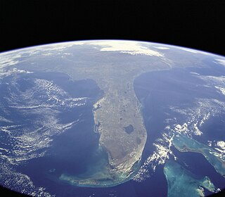
Sakhalin is Russia's largest island, lying in the North Pacific Ocean between 45°50' and 54°24' N. It is administered as part of Sakhalin Oblast. Sakhalin, which is about one third the size of Honshu, is just off the east coast of Russia, and just north of Japan. The island's population was 497,973 as of the 2010 census, made up of mostly ethnic Russians and a smaller Korean community. The indigenous peoples of the island are the Ainu, Oroks and Nivkhs.
Cape Dezhnyov or Cape Dezhnev is a cape that forms the eastmost mainland point of Asia. It is located on the Chukchi Peninsula in the very sparsely populated Chukotka Autonomous Okrug of Russia. This cape is located between the Chukchi Sea and the Bering Strait, 82 kilometres (51 mi) across from Cape Prince of Wales in Alaska; the Bering Strait is delimited by the two capes. The Diomede Islands and Fairway Rock are located in the midst of the strait.

The Sea of Japan is the marginal sea between the Japanese archipelago, Sakhalin, the Korean Peninsula and Russia. The Japanese archipelago separates the sea from the Pacific Ocean. It is bordered by Japan, Korea and Russia. Like the Mediterranean Sea, it has almost no tides due to its nearly complete enclosure from the Pacific Ocean. This isolation also reflects in the fauna species and in the water salinity, which is lower than in the ocean. The sea has no large islands, bays or capes. Its water balance is mostly determined by the inflow and outflow through the straits connecting it to the neighboring seas and Pacific Ocean. Few rivers discharge into the sea and their total contribution to the water exchange is within 1%.

The Gulf of Saint Lawrence is the outlet of the North American Great Lakes via the Saint Lawrence River into the Atlantic Ocean. The gulf is a semienclosed sea, covering an area of about 226,000 square kilometres (87,000 sq mi) and containing about 34,500 cubic kilometres (8,300 cu mi) of water, which results in an average depth of 152 metres (499 ft).

The Laptev Sea is a marginal sea of the Arctic Ocean. It is located between the northern coast of Siberia, the Taimyr Peninsula, Severnaya Zemlya and the New Siberian Islands. Its northern boundary passes from the Arctic Cape to a point with co-ordinates of 79°N and 139°E, and ends at the Anisiy Cape. The Kara Sea lies to the west, the East Siberian Sea to the east.

Baffin Bay, located between Baffin Island and the west coast of Greenland, is a marginal sea of the North Atlantic Ocean. It is connected to the Atlantic via Davis Strait and the Labrador Sea. The narrower Nares Strait connects Baffin Bay with the Arctic Ocean. The bay is not navigable most of the year because of the ice cover and high density of floating ice and icebergs in the open areas. However, a polynya of about 80,000 km2 (31,000 sq mi), known as the North Water, opens in summer on the north near Smith Sound. Most of the aquatic life of the bay is concentrated near that region.

Livingston Island is an Antarctic island in the South Shetland Islands, Western Antarctica lying between the islands of Greenwich and Snow. This island was the first land discovered south of 60° south latitude in 1819, and the name Livingston, although of unknown derivation, has been well established in international usage since the early 1820s.

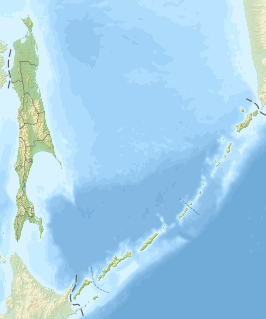
Cape Sōya is the northernmost point of the island of Hokkaidō, Japan. It is situated in Wakkanai, Sōya Subprefecture. The Monument of the Northernmost Point of Japan (日本最北端の地の碑) is at the cape, although the true northernmost point under Japanese control is a small deserted island called Bentenjima, 1 km northwest. Since the cape is just 43 km away across La Perouse Strait from Cape Crillon, Sakhalin Island, Russia, it is possible to catch a glimpse of the island of Sakhalin on a clear day.
Karafuto was a former Japanese prefecture in the southern part of Sakhalin island, from 1905 to 1945.
Gulf of Patience is a large body of water off the southeastern coast of Sakhalin, Russia.
Jackson Island is an island located in Franz Josef Land, Arkhangelsk Oblast, Russian Federation. This island is part of the Zichy Land subgroup of the central part of the archipelago.

Hall Island is an island in Franz Josef Land, Arkhangelsk Oblast, Russia.

Cape Crillon is the southernmost point of Sakhalin. The cape was named by Frenchman Jean-François de La Pérouse, who was the first European to discover it. Cape Sōya, in Japan, is located 43 km to the south, across La Pérouse Strait.

Tyuleny Island is a small island in the Sea of Okhotsk, just east of Russia's Sakhalin island, Northeast Asia.

The Spafaryev Islands, or Spafaryev Island, a relatively large double island, are located in the Sea of Okhotsk. It was formerly known as Korovi Island. It lies 7 km east of the Antamlan Peninsula, the southernmost peninsula enclosing the Taui Bay from its western side.
Cape Elizabeth is a cape on the Schmidt Peninsula. It is the northernmost point of Sakhalin.
The Laconian Gulf, is a gulf in the south-eastern Peloponnese, in Greece. It is the southernmost gulf in Greece and the largest in the Peloponnese. In the shape of an inverted "U", it is approximately 58 km wide east-west, and 44 km long north-south. It is bounded to the west by the Mani peninsula, which separates it from the Messenian Gulf, and to the east by the Cape Maleas peninsula, which separates it from the Aegean Sea. To the south it opens onto the Mediterranean Sea. The Mani and Cape Maleas peninsulas are dry and rocky, but the northern shore, fed by the Evrotas River, which empties into the gulf at its apex, is fertile farmland. The island of Elafonissos lies in the Laconian Gulf, with the island of Kythira directly to the south. The main ports and settlements on the gulf are Gytheio and Neapolis.

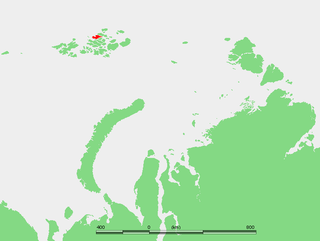
The Geography of Franz Josef Land refers to an island group belonging to Arkhangelsk Oblast of Russia. It is situated in the Barents Sea of the Arctic, north of Novaya Zemlya and east of Svalbard. At latitudes between 80.0° and 81.9° north, it is the most northerly group of islands associated with Eurasia. The extreme northernmost point is Cape Fligely on Rudolf Island. The archipelago consists of 191 ice-covered islands with a total area of 16,134 km2 (6,229 sq mi). It is currently uninhabited. The archipelago is only 900 to 1,110 km from the North Pole, and the northernmost islands are closer to the Pole than any other land except for Canada's Ellesmere Island and Greenland. The largest island is Zemlya Georga which measures 110 km (68 mi) from end to end. The highest point in the archipelago is on Ostrov Viner-Neyshtadt which reaches 620 m (2,034 ft) above sea level. The central cluster of large islands in the midst of the archipelago forms a compact whole, known as Zichy Land, where islands are separated from each other by very narrow sounds that are frozen most of the year.

Poronaysky Nature Reserve is a Russian 'zapovednik' covering Cape Patience, on the eastern side of Sakhalin Island in the Russian Far East. A specific purpose of the reserve is to protect rookeries for arctic birds on Cape Patience, which is a 65 km peninsula extending into the Okhotsk Sea. The reserve includes the southern part of the East Sakhalin Mountains, and the widest part of the Tym-Poronaisk dale. The reserve is situated in the Poronaysky District of Sakhalin Oblast, 50 km east of the regional city of Poronaysk. It was formally established in 1988, and covers 56,695 ha (218.90 sq mi).