
The Sea of Okhotsk is a marginal sea of the western Pacific Ocean. It is located between Russia's Kamchatka Peninsula on the east, the Kuril Islands on the southeast, Japan's island of Hokkaido on the south, the island of Sakhalin along the west, and a stretch of eastern Siberian coast along the west and north. The northeast corner is the Shelikhov Gulf. The sea is named after Okhotsk, the first Russian settlement in the Far East.

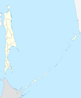
Sakhalin is the largest island of Russia. It is north of the Japanese archipelago, and is administered as part of the Sakhalin Oblast. Sakhalin is situated in the Pacific Ocean, sandwiched between the Sea of Okhotsk to the east and the Sea of Japan to the west. It is located just off Khabarovsk Krai, and is north of Hokkaido in Japan. The island houses a population of roughly 500,000, the majority of which are Russians.

Strait of Tartary or Gulf of Tartary is a strait in the Pacific Ocean dividing the Russian island of Sakhalin from mainland Asia, connecting the Sea of Okhotsk on the north with the Sea of Japan on the south. It is 632 kilometres (393 mi) long, 7–342 kilometres (4.3–212.5 mi) wide, and less than 210 m (690 ft) deep at its deepest point.

The Sea of Japan(see below for other names) is the marginal sea between the Japanese archipelago, Sakhalin, the Korean Peninsula, and the mainland of the Russian Far East. The Japanese archipelago separates the sea from the Pacific Ocean. Like the Mediterranean Sea, it has almost no tides due to its nearly complete enclosure from the Pacific Ocean. This isolation also affects faunal diversity and salinity, both of which are lower than in the open ocean. The sea has no large islands, bays or capes. Its water balance is mostly determined by the inflow and outflow through the straits connecting it to the neighboring seas and the Pacific Ocean. Few rivers discharge into the sea and their total contribution to the water exchange is within 1%.

The Gulf of St. Lawrence is the outlet of the North American Great Lakes via the St. Lawrence River into the Atlantic Ocean. The gulf is a semi-enclosed sea, covering an area of about 226,000 square kilometres (87,000 sq mi) and containing about 34,500 cubic kilometres (8,300 cu mi) of water, which results in an average depth of 152 metres (499 ft).

The Spencer Gulf is the westernmost and larger of two large inlets on the southern coast of Australia, in the state of South Australia, facing the Great Australian Bight. It spans from the Cape Catastrophe and Eyre Peninsula in the west to Cape Spencer and Yorke Peninsula in the east.
Karafuto was a former Japanese prefecture in the southern part of Sakhalin island, from 1905 to 1945.

Vladimir Ivanovich Voronin was a Soviet Navy captain, born in Sumsky Posad, in the present Republic of Karelia, Russia. In 1932 he commanded the expedition of the Soviet icebreaker A. Sibiryakov which made the first successful crossing of the Northern Sea Route in a single navigation without wintering. This voyage was organized by the All-Union Arctic Institute.

Tyuleny Island is a small island in the Sea of Okhotsk, east of Russia's Sakhalin Island, in Northeast Asia. It is also called Kaihyo Island (海豹島).
Ush Island is an island in the northern coast of Sakhalin. Ush Island is located between a shallow bay and the Sea of Okhotsk, at the mouth of the Sakhalin Gulf.

Maarten Gerritszoon Vries, or Fries, also referred to as de Vries, was a 17th-century Dutch cartographer and explorer, the first Western European to leave an account of his visit to Ezo, Sakhalin, Kuril Islands and the Sea of Okhotsk.

The Nevelskoy Strait is a strait within the Strait of Tartary located at the narrowest point between Sakhalin and the Asian mainland. The Nevelskoy Strait is administratively part of Russia on the border between Khabarovsk Krai and Sakhalin Oblast in the Russian Far East region.
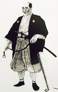
Mamiya Rinzō was a Japanese explorer of the late Edo period. He is best known for his exploration of Karafuto, now known as Sakhalin. He mapped areas of northeast Asia then unknown to Japanese.

Cape Patience is a peninsula protruding 65 km (40 mi) km of east-central Sakhalin Island into the Sea of Okhotsk. It forms the eastern boundary of the Gulf of Patience. The width of the peninsula varies from less than 1 km (0.62 mi), at the Lodochniy Isthmus, to 30 km (19 mi) at its widest point. It reaches a maximum elevation of 350 m (1,150 ft). The cape is the southernmost extension of the East Sakhalin Mountains, a north-south range that runs along the eastern side of Sakhalin Island.
Sakhalin Ainu was an Ainu language, or perhaps several Ainu languages, spoken on the island of Sakhalin, now part of Russia.

Poronaysky Nature Reserve is a Russian 'zapovednik' covering Cape Patience, on the eastern side of Sakhalin Island in the Russian Far East. A specific purpose of the reserve is to protect rookeries for arctic birds on Cape Patience, which is a 65 km peninsula extending into the Okhotsk Sea. The reserve includes the southern part of the East Sakhalin Mountains, and the widest part of the Tym-Poronaisk dale. The reserve is situated in the Poronaysky District of Sakhalin Oblast, 50 km east of the regional city of Poronaysk. It was formally established in 1988, and covers 56,695 ha (218.90 sq mi).

Schmidt Peninsula is a peninsula in Sakhalin Oblast, Russian Federation. It is the northernmost point of Sakhalin Island and is located north of Okha town.
