
The Gulf of St. Lawrence is the outlet of the North American Great Lakes via the St. Lawrence River into the Atlantic Ocean. The gulf is a semi-enclosed sea, covering an area of about 226,000 square kilometres (87,000 sq mi) and containing about 34,500 cubic kilometres (8,300 cu mi) of water, at an average depth of 152 metres (500 ft).

Cape Spear is a headland located on the Avalon Peninsula of Newfoundland near St. John's in the Canadian province of Newfoundland and Labrador. At a longitude of 52°37' W, it is the easternmost point in Canada and North America, excluding Greenland.
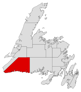
Burgeo-La Poile is a provincial electoral district for the House of Assembly of Newfoundland and Labrador, Canada. As of 2011, there are 7,527 eligible voters living within the district. The district was first created when Newfoundland joined confederation in 1949 as Burgeo and La Poile, and existed until 1975. It was recreated in 1995 following a reduction in the number of seats in the House of Assembly from 52 to 48, forming from the amalgamation of the former districts of La Poile and Burgeo-Bay D'Espoir.

Battle Harbour is a summer fishing station, formerly a permanent settlement, located on the Labrador coast in the province of Newfoundland and Labrador, Canada. Battle Harbour was for two centuries the economic and social centre of the southeastern Labrador coast. Mercantile saltfish premises first established there in the 1770s developed into a thriving community that was known as the Capital of Labrador. It fell into decline following reductions in the cod fishery and a major fire in 1930, and was abandoned as a permanent settlement following government resettlement activity in the 1960s.
St. George's Bay - informally referred to as Bay St. George due to its French translation Baie St-George - is a large bay in the province of Newfoundland and Labrador, Canada. It is located on the west coast of the island of Newfoundland and comprises a sub-basin of the Gulf of St. Lawrence.
The Burin Peninsula is a peninsula located on the south coast of the island of Newfoundland in the province of Newfoundland and Labrador. Marystown is the largest population centre on the peninsula.

St. George's is a Canadian community in the St. George's Bay on the southwest coast of Newfoundland of the province of Newfoundland and Labrador.

Route 460 is an 87.5-kilometre-long (54.4 mi) east-west Canadian provincial highway in Newfoundland and Labrador.
Triton is a town that lies on Triton Island just off the coast of northeastern Newfoundland, in the Canadian province of Newfoundland and Labrador. Triton is the economic center of Green Bay South. According to Statistics Canada, Triton's population fell from 983 in 2016 to 896 in 2021.

Rose Blanche – Harbour le Cou is a small town on Newfoundland's southwest shore, about 45 km at the end of Route 470 from Port aux Basques. This community is located in a barren area on the east side of a small bay. In this bay there are 2 harbours that were mainly used to provide shelter for fishing vessels. Scenery includes the rugged granite coastline, and the white and rocky cliffs of "Diamond Cove". Its granite lighthouse was in operation from 1873 to the 1940s. After it was abandoned in the 1940s the building fell into ruins. The spiral stone staircase extends into the tower wall and kept the tower from collapsing while the remainder of the lighthouse fell to ruin. In 1999 the lighthouse was fully reconstructed and serves as a tourist attraction.
The Bonavista Peninsula is a large peninsula on the east coast of the island of Newfoundland in the Canadian province of Newfoundland and Labrador. It consists of 50 incorporated towns/unincorporated communities which have a population of 12,176 as of the 2016 Canadian Census. Bonavista is the largest population centre on the peninsula.
Musgrave Harbour is a town and designated place in the Canadian province of Newfoundland and Labrador.
Cape Island is the name of both an island and a former community in the Canadian province of Newfoundland and Labrador.
Cape Freels is one of the communities that comprise an area on the northeast coast of the Island of Newfoundland, called Bonavista North, in the province of Newfoundland and Labrador, Canada. These communities have a shared history in that they were settled by people from England, predominantly from the West Country - Dorset, Devon, Somerset and Hampshire.
Fermeuse is a town in the Canadian province of Newfoundland and Labrador. The town had a population of 266 in the Canada 2021 Census.

Humber Arm South is a town in the Canadian province of Newfoundland and Labrador. The town consists of the communities of Halfway Point, Benoit's Cove, John's Beach, and Frenchman's Cove. The town had a population of 1,537 in the Canada 2021 Census. The Town's Post Office is located in Benoit's Cove. Humber Arm South is located in the Bay of Islands and is in the Humber-Bay of Islands electoral district. The town's residents are of Mi'kmaw, Innu, and European descent.
Chimney Cove is an abandoned community in Newfoundland and Labrador located to the south of Cape St. Gregory.
Isthmus Bay is a natural bay on the island of Newfoundland in the province of Newfoundland and Labrador, Canada. It is a sub-bay of St. George's Bay and flanked by the town of Port-au-Port. It is separated from Port au Port Bay by two narrow gravel isthmi.
Woody Bay is a natural bay on the island of Newfoundland in the province of Newfoundland and Labrador, Canada. Located 0.5 miles (0.80 km) from Little Port, Woody Bay is about two cables in diameter, and fit for boats only, that have considerable difficulty in entering with westerly winds.

Division No. 1, Subdivision G is an unorganized subdivision on the Avalon Peninsula in Newfoundland and Labrador, Canada. It is in Division 1 and contains the unincorporated communities of Baccalieu Island, Besom Cove, Bradley's Cove, Burnt Point, Caplin Cove, Daniel's Cove, Grates Cove, Gull Island, Job's Cove, Kingston, Long Beach, Lower Island Cove, Low Point, Northern Bay, Ochre Pit Cove, Red Head Cove, Riverhead, Smooth Cove and Western Bay.
