
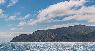
Arapaoa Island is the second-largest island in the Marlborough Sounds, at the north-east tip of the South Island of New Zealand. The island has a land area of 75 km2. Queen Charlotte Sound defines its western side, while to the south lies Tory Channel, which is on the sea route between Wellington in the North Island to Picton. Cook Strait's narrowest point is between Arapaoa Island's Perano Head and Cape Terawhiti in the North Island.
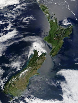
New Zealand is an island country located in the southwestern Pacific Ocean, near the centre of the water hemisphere. It consists of a large number of islands, estimated around 700, mainly remnants of a larger landmass now beneath the sea. The land masses by size are the South Island and the North Island, separated by the Cook Strait. The third-largest is Stewart Island / Rakiura, located 30 kilometres off the tip of the South Island across Foveaux Strait. Other islands are significantly smaller in area. The three largest islands stretch 1,600 kilometres across latitudes 35° to 47° south. New Zealand is the sixth-largest island country in the world, with a land size of 268,680 km2 (103,740 sq mi).

The North Island, also officially named Te Ika-a-Māui, is one of the two main islands of New Zealand, separated from the larger but less populous South Island by Cook Strait. With an area of 113,729 km2 (43,911 sq mi), it is the world's 14th-largest island, constituting 43% of New Zealand's land area. It has a population of 3,997,300, which is 77% of New Zealand's residents, making it the most populous island in Polynesia and the 28th-most-populous island in the world.

The Tasman Sea is a marginal sea of the South Pacific Ocean, situated between Australia and New Zealand. It measures about 2,000 km (1,200 mi) across and about 2,800 km (1,700 mi) from north to south. The sea was named after the Dutch explorer Abel Janszoon Tasman, who in 1642 was the first known person to cross it. British explorer Lieutenant James Cook later extensively navigated the Tasman Sea in the 1770s during his three voyages of exploration.
Cook Strait is a strait that separates the North and South Islands of New Zealand. The strait connects the Tasman Sea on the northwest with the South Pacific Ocean on the southeast. It is 22 kilometres (14 mi) wide at its narrowest point, and is considered one of the most dangerous and unpredictable waters in the world. Regular ferry services run across the strait between Picton in the Marlborough Sounds and Wellington.
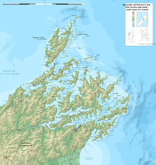
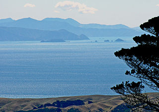
The Marlborough Sounds are an extensive network of sea-drowned valleys at the northern end of the South Island of New Zealand. The Marlborough Sounds were created by a combination of land subsidence and rising sea levels. According to Māori mythology, the sounds are the prows of the many sunken waka of Aoraki.
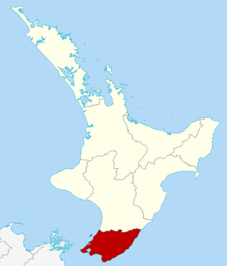
Greater Wellington, also known as the Wellington Region, is a non-unitary region of New Zealand that occupies the southernmost part of the North Island. The region covers an area of 8,049 square kilometres (3,108 sq mi), and has a population of 550,500.
The HVDC Inter-Island link is a 610 km (380 mi) long, 1200 MW high-voltage direct current (HVDC) transmission system connecting the electricity networks of the North Island and South Island of New Zealand together. It is commonly referred to as the Cook Strait cable in the media and in press releases, although the link is much longer than its Cook Strait section. The link is owned and operated by state-owned transmission company Transpower New Zealand.

The Brothers is a group of small islands in Cook Strait, New Zealand, off the east coast of Cape Koamaru, Arapaoa Island. The islands are a restricted-access wildlife sanctuary administered by the Department of Conservation.

Moturoa / Rabbit Island is a small island that lies across the southernmost part of Tasman Bay / Te Tai-o-Aorere, on the northern coast of New Zealand's South Island. The long narrow island runs east–west for 8 kilometres (5 mi), and covers 15 km2 (5.8 sq mi).

Cape Campbell, Te Rae-o-te-kōhaka in the Māori language, is in Marlborough, New Zealand, on the northeastern coast of the South Island. It lies at the southern end of Clifford Bay, 15 kilometres (9 mi) northeast of Ward, and 42 kilometres (26 mi) southeast of Blenheim. Cape Campbell lies close to the salt works at Lake Grassmere.

Cape Turnagain is a prominent headland on the east coast of New Zealand's North Island, part way between Hawke Bay and Cook Strait, between the mouths of the Porangahau and Ākitio Rivers.

Cape Palliser is a promontory on the southern coast of New Zealand's North Island and is the southernmost point of the North Island; it is in fact considerably farther south than Nelson or Blenheim in the South Island.

North Cape / Otou is the northernmost point of New Zealand's main islands. At the northeastern tip of the Aupōuri Peninsula, the cape lies 30 kilometres (19 mi) east and three kilometres (1.9 mi) north of Cape Reinga. The name North Cape is sometimes used to refer just to the cape that is known in Māori as Otou and which overlooks Murimotu Island, and sometimes just to the eastern point of Murimotu Island. It is also used to refer to the whole larger headland stretching about five kilometres from Murimotu Island westwards to Kerr Point and including the Surville Cliffs. Statistics New Zealand uses a statistical area called North Cape for population data, extending south down the Aupōuri Peninsula to the Houhora Heads.
The cluster of rocks that is Barrett Reef is one of the most hazardous reefs in New Zealand.

Rotokura / Cable Bay is a bay and small settlement 18 kilometres (11 mi) north-east of Nelson in New Zealand. The settlement at the head of the bay is at the southern end of a thin strip of land or causeway connecting Pepin Island with the South Island.
Terawhiti Station is one of New Zealand's oldest and largest sheep stations, located along the south coast of Wellington. Terawhiti Station has seen a diverse range of land uses over the past 160 years. Originally a cattle station, Terawhiti grew into one of New Zealand's largest sheep stations before returning to cattle in 1993. The station originally consisted of the upraised marine terrace at Tongue Point on Wellington's south coast and was purchased by two Wellington businessmen Samuel Revans and William Mein Smith following the sale of Crown 'waste lands'. Captain William Barnard Rhodes later bought Revans’s land at Tongue Point stocking it with shorthorn cattle. His young manager, James McMenamen, later bought the Tongue Point farm and neighbouring blocks, forming Terawhiti Station and (later) Te Kamaru Station.

Mākara is a locality located at the western edge of Wellington, New Zealand, close to the shore of the Tasman Sea. The suburb is named after the Mākara Stream.
Sinclair Head / Te Rimurapa is a major promontory on the south coast of New Zealand's North Island. It lies 14 kilometres (8.7 mi) to the west of the entrance to Wellington Harbour, and a similar distance to the east of Cape Terawhiti.


