
Capital Cascade Greenway is an urban greenway in Tallahassee, Florida, United States designed for managing stormwater, enhancing natural and cultural heritage, and assist in promoting sustainable development.
Capital Cascade Greenway is an urban greenway in Tallahassee, Florida, United States designed for managing stormwater, enhancing natural and cultural heritage, and assist in promoting sustainable development.
The Capital Cascade Greenway is a 6-mile (9.6 km) long greenway through downtown Tallahassee that follows the course of the St. Augustine Branch, a small creek that flows south through Cascades Park, Black Swamp, and ends in Lake Munson. The project corridor includes both public and private land.
The birth of the Capital Cascade Greenway came from Tallahassee's Blueprint 2000, an initiative to provide stormwater, trail and road projects that are efficient, attractive, environmentally responsible, and support the revitalization of in-town and southside neighborhoods. It is funded by an extension of the local one-cent sales tax approved by voters in November 2000. The U.S. Environmental Protection Agency and the Department of Community Affairs have invested $7.8 million to the project. The Trust for Public Land is also a partner in the greenway's creation.
The greenway will address stormwater and flooding problems in southern Tallahassee where the St. Augustine Branch basin slopes steeply near downtown. Almost the whole basin is built upon which has increased the amount of impervious surfaces leaving no absorption area for rain.
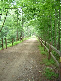
Capital Cascade Greenway will include trails for walking, and biking and link to the St. Mark's Trail, the Bow Tie Trail and the proposed Gopher, Frog and Alligator Trail (GFA.) The greenway will also have parks and playgrounds, businesses and shops and an opportunity to preserve a historic section of Florida's capital city. Parts of the corridor house the Korean War Memorial as well as historic plaques that commemorate the beginnings of Tallahassee and the State of Florida. The corridor is also very close to a number of structures listed on the National Register of Historic Places as well as historic neighborhoods such as Stearns-Mosely.
The East Coast Greenway is a 3,000-mile (4,800 km) pedestrian and bicycle route between Maine and Florida along the East Coast of the United States. In 2020, the Greenway received over 50 million visits.

Rock Creek is a free-flowing tributary of the Potomac River that empties into the Atlantic Ocean via the Chesapeake Bay. The 32.6-mile (52.5 km) creek drains about 76.5 square miles (198 km2). Its final quarter-mile is affected by tides.
The Atlanta BeltLine is a 22 miles (35 km) open and planned loop of multi-use trail and light rail transit system on a former railway corridor around the core of Atlanta, Georgia. The Atlanta BeltLine is designed to reconnect neighborhoods and communities historically divided and marginalized by infrastructure, improve transportation, add green space, promote redevelopment, create and preserve affordable housing, and showcase arts and culture. The project is in varying stages of development, with several mainline and spur trails complete and others in an unpaved, but hikeable, state. Since the passage of the More MARTA sales tax in 2016, construction of the light rail streetcar system is overseen by MARTA in close partnership with Atlanta BeltLine, Inc.

Paynes Prairie Preserve State Park is a Florida State Park, encompassing a 21,000-acre (85 km2) savanna in Alachua County, Florida lying between Micanopy and Gainesville. It is also a U.S. National Natural Landmark. It is crossed by both I-75 and U.S. 441. It is in the center of the Paynes Prairie Basin. The basin's primary source of drainage is Alachua Sink. During occasional wet periods, the basin will become full. A notable period occurred from 1871 to 1891 when the Alachua Sink was temporarily blocked. During this period, shallow draft steamboats were a frequent sight on Alachua Lake in the center of the prairie. The region was also historically known as the Alachua Savannah. Its drainage has been modified by several canals. Since 1927, Camps Canal has linked the basin to the River Styx which leads to Orange Lake and eventually the Atlantic Ocean through the St. Johns River. That reduced the basins water intake by half. Additional changes to the prairie's environment have been detrimental to its hydrology. In 1970, the state of Florida acquired the land and has been in the process of restoring the environment to a more natural condition ever since.

Alewife Brook Reservation is a Massachusetts state park and urban wild located in Cambridge, Arlington, and Somerville. The park is managed by the state Department of Conservation and Recreation and was established in 1900. It is named for Alewife Brook, which was also historically known as Menotomy River, a tributary of the Mystic River.

A greenway is usually a shared-use path along a strip of undeveloped land, in an urban or rural area, set aside for recreational use or environmental protection. Greenways are frequently created out of disused railways, canal towpaths, utility or similar rights of way, or derelict industrial land. Greenways also can also be linear parks, and can serve as wildlife corridors. The path's surface may be paved and often serves multiple users: walkers, runners, bicyclists, skaters and hikers. A characteristic of greenways, as defined by the European Greenways Association, is "ease of passage": that is that they have "either low or zero gradient", so that they can be used by all "types of users, including mobility impaired people".
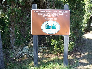
Tallahassee-St. Marks Historic Railroad State Trail is a rail trail and Florida State Park located on 16 miles (26 km) of the historic railbed of the Tallahassee Railroad, which ran between Tallahassee and St. Marks, Florida. The trail ends near the confluence of the St. Marks and Wakulla Rivers. The portion of the trail south of US 98 is designated as a portion of the Florida National Scenic Trail. A paved extension of the trail extends north for approximately 4 miles (6.4 km) into the City of Tallahassee.

Daylighting can be defined as "opening up buried watercourses and restoring them to more natural conditions". An alternative definition refers to "the practice of removing streams from buried conditions and exposing them to the Earth's surface in order to directly or indirectly enhance the ecological, economic and/or socio-cultural well-being of a region and its inhabitants”. The term is used to refer to the restoration of an originally open-air watercourse, which had at some point been diverted below ground, back into an above-ground channel. Typically, the rationale behind returning the riparian environment of a stream, wash, or river to a more natural state is to reduce runoff, create habitat for species in need of it, or improve an area's aesthetics. In the UK, the practice is also known as deculverting.
The history of Tallahassee, Florida, much like the history of Leon County, dates back to the settlement of the Americas. Beginning in the 16th century, the region was colonized by Europeans, becoming part of Spanish Florida. In 1819, the Adams–Onís Treaty ceded Spanish Florida, including modern-day Tallahassee, to the United States. Tallahassee became a city and the state capital of Florida in 1821; the American takeover led to the settlements' rapid expansion as growing numbers of cotton plantations began to spring up nearby, increasing Tallahassees' population significantly.
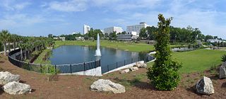
Cascades Park is a 24-acre (97,000 m2) park along the stream known as the St. Augustine Branch in Tallahassee, Florida, south of the Florida State Capitol. It is a Nationally Registered Historic Place because it influenced the territorial government's choice of the capital city's location. It also contains Florida's Prime meridian marker monument which is the foundation point for most land mapping throughout Florida.
The Trust for Public Land is a U.S. nonprofit organization with a mission to "create parks and protect land for people, ensuring healthy, livable communities for generations to come". Since its founding in 1972, The Trust for Public Land has completed 5,000 park-creation and land conservation projects across the United States, protected over 3 million acres, and helped pass more than 500 ballot measures—creating $70 billion in voter-approved public funding for parks and open spaces. The Trust for Public Land also researches and publishes authoritative data about parks, open space, conservation finance, and urban climate change adaptation. Headquartered in San Francisco, the organization is among the largest U.S. conservation nonprofits, with approximately 30 field offices across the U.S., including a federal affairs function in Washington, D.C.

The Great Rivers Greenway District is a public agency created in 2000 to develop a regional network of greenways. Great Rivers Greenway engages citizens and community partners to plan, build and care for the greenways. In its first 20 years the agency built more than 128 miles of greenways connecting parks, rivers, schools, neighborhoods, business districts and transit.
The Florida Department of Environmental Protection (FDEP) is the Florida government agency charged with environmental protection.

A sediment basin is a temporary pond built on a construction site to capture eroded or disturbed soil that is washed off during rain storms, and protect the water quality of a nearby stream, river, lake, or bay. The sediment-laden soil settles in the pond before the runoff is discharged. Sediment basins are typically used on construction sites of 5 acres (20,000 m2) or more, where there is sufficient room. They are often used in conjunction with erosion controls and other sediment control practices. On smaller construction sites, where a basin is not practical, sediment traps may be used.

The Jacksonville-Baldwin Rail Trail is a rail trail that extends from northwest Jacksonville to Baldwin, Florida. While it is technically a city park, it includes three separate paths: a multi-use asphalt trail for hiking, jogging, in-line skating or cycling; an off-road bike trail; and a horseback riding trail.

The Palatka-Lake Butler State Trail (PLB) corridor stretches nearly 47 miles (76 km) from the vicinity of Lake Butler, Florida to Palatka, Florida. The project is located along the former Georgia Southern and Florida Railway right-of-way and the trail is being constructed on top of the existing abandoned railroad bed through Putnam, Clay, Bradford, and Union counties.

North Florida is a region of the U.S. state of Florida comprising the northernmost part of the state. Along with South Florida and Central Florida, it is one of Florida's three most common "directional" regions. It includes Jacksonville and nearby localities in Northeast Florida, an interior region known as North Central Florida, and the Florida Panhandle.
Florida Ecological Greenways Network work to provide a "system of native landscapes and ecosystems that supports native plant and animal species, sustains clean air, water, fisheries, and other natural resources, and maintains the scenic natural beauty that draws people to visit and settle in Florida," as stated Florida Greenways Commission. It also functions to devise a plan for a statewide greenways system, based on GIS technology and suggestions from the public. The GIS data used includes soil, water, and geological information, wildlife movements and habitat data, as well as existing trails and parks, transportation and infrastructure fixtures, educational and historical sites, and political boundaries. This system would be created in accordance with the December 1994 report from the Florida Greenways Commission to the Governor of the state of Florida, a report which outlined the protocol for creating it. Such a system would connect all aspects of the state's "green infrastructure", making it more comprehensive for use by the state's citizens and more effective in achieving greater sustainability throughout the state of Florida for generations to come.

The Nature Coast State Trail (NCST) is a 31.7-mile long segment of Florida's Statewide System of Greenways and Trails System built along abandoned railroad tracks, and designated by the U.S. Department of the Interior as a National Recreation Trail. It has two primary sections following unused rail lines that were originally built by the Atlantic Coast Line Railroad. It includes historic sites such as an old train trestle bridge over the Suwannee River near Old Town and train stations in Trenton, Cross City, and Chiefland. At Wilcox Junction abandoned rail tracks cross and connect with several communities. The trail is available to hikers, cyclists, and horse riders.

The Lafitte Greenway is a trail for pedestrians and bicycles located in New Orleans, Louisiana, extending from Louis Armstrong Park to Bayou St. John and beyond. Opened in 2015, it is the latest reconfiguration of a historic transportation corridor that has been in use for over two centuries.