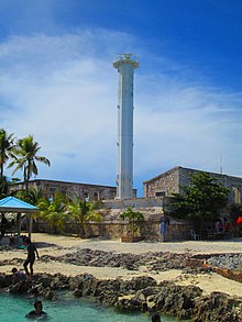
Chile has a large and intricate coastline of 4000 km with myriads of islands, islets, straits, bays, and fjords.

Bogo, officially the City of Bogo, is a 6th class component city in the province of Cebu, Philippines. According to the 2020 census, it has a population of 88,867 people.

Cape Bojeador Lighthouse, also known as Burgos Lighthouse, is a cultural heritage structure in Burgos, Ilocos Norte, that was established during the Spanish colonial period in the Philippines. The lighthouse was first lit on March 30, 1892, and is set high on Vigia de Nagpartian Hill overlooking the scenic Cape Bojeador where early galleons used to sail by. After over 100 years, it still functions and serves ships that enter the Philippine archipelago from the north and guide them safely away from the rocky coast of the town.

The Cabra Island Lighthouse is a historic lighthouse built on Cabra Island, the north-westernmost of the Lubang group of islands in Occidental Mindoro, Philippines. International vessels entering the Philippines from South China Sea were welcomed by the Cabra Light and directed either towards Manila Bay or the center of the archipelago through Verde Island Passage, one of busiest sea routes of the Philippines.
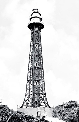
The Apo Reef Light was a historic lighthouse built on Bajo Apo Island in Apo Reef Natural Park. The park is located in the middle of Mindoro Strait, west of the province of Occidental Mindoro, in the Philippines. The station was established to warn ships of the dangerous shallow reefs in that part of the strait.

Cape Engaño Lighthouse, also known as Faro de Cabo Engaño, is a historic lighthouse located at Cape Engaño on Palaui Island in the town of Santa Ana, the province of Cagayan, Philippines. Located at the northernmost part of Luzon Island and situated atop the summit of a hill, 92 meters above sea level, the lighthouse provides a 360-degree view of Babuyan Island and the Dos Hermanas Island on the North, Pacific Ocean on the West and Engaño cove on the East.

Capones Island Lighthouse is a historic lighthouse located in Capones Island off the coast of Barangay Pundaquit, San Antonio, in the province of Zambales, in the Philippines. The light guides international vessels coming from the north to northwest towards Subic Bay or to Corregidor Island Lighthouse at the entrance of Manila Bay. It had first-order lenses when it was first lit on August 1, 1890.
Manigonigo Island is an island in northeastern Iloilo, Philippines. It is one of fourteen islands politically administered by the municipality of Carles. The island's lighthouse was built by the Spanish during Spanish rule.
Tanguingui is a small, uninhabited island in the Visayan Sea of the Philippines. The island is under the jurisdiction of the municipality of Madridejos, Cebu. There is a lighthouse on the island.
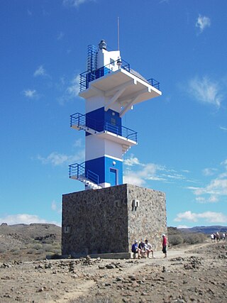
The Punta del Castillete Lighthouse is an active lighthouse on the Canary island of Gran Canaria. It is located on cliffs above the resort and fishing harbour of Puerto de Mogán, in the municipality of Mogán. Punta Castillete is on the south-western side of the island facing the Atlantic Ocean, and lies between Maspalomas Lighthouse to the south and the lighthouse of Punta Sardina to the north.
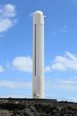
The Arenas Blancas Lighthouse is an active lighthouse on the Canary island of La Palma in the municipality of Villa de Mazo, near the village of La Salemera. The larger settlement of Mazo lies 8 km (5.0 mi) to the north-west.

The Punta Sardina Lighthouse is an active lighthouse on the Canary island of Gran Canaria. It is located north of the small town of Sardina, in the municipality of Gáldar. The Punta Sardina light marks the north-western extremity of the island, and lies between the Punta del Castillete lighthouse near Puerto de Mogán to the south and the La Isleta lighthouse of Las Palmas to the east.
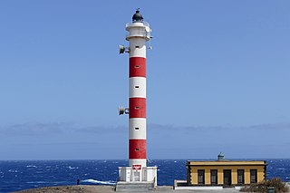
The Punta Abona Lighthouse is an active lighthouse on the south-eastern coast of Tenerife in the Canary islands. It is located between Abades and Poris de Abona, in the municipality of Arico. The lighthouse was the second to be constructed on the rocky headland of Punta Abona, which marks the south-east side of the island, and lies between the Punta de Anaga Lighthouse to the north and the Punta Rasca Lighthouse of Arona to the south.

The Punta Rasca Lighthouse is an active lighthouse in the municipality of Arona on the Canary Island of Tenerife. The current lighthouse was the second to be constructed on the headland of Punta Rasca, which is located close to the most southerly point on the island at Punta Salemas. It lies between the Punta Abona Lighthouse to the northeast and the Punta de Teno Lighthouse of Buenavista del Norte to the northwest.

The Punta de Teno Lighthouse is an active lighthouse in the municipality of Buenavista del Norte on the Canary Island of Tenerife. The current lighthouse was the second to be constructed on the narrow rocky headland of Punta de Teno, which is the most westerly point on the island. It is one of seven lighthouses which mark the coastline of Tenerife, and lies between the Punta Rasca Lighthouse to the southeast, and the modern lighthouse of Buenavista to the northeast.

The Punta de Melenara Lighthouse also known as the Faro de Taliarte is an active 20th century lighthouse on the Spanish island of Gran Canaria in the Canary islands.

Punta Delgada or Alegranza Lighthouse is an active 19th century lighthouse on the Spanish island of Alegranza in the Canary islands. Alegranza lies to the north of the larger island of Lanzarote, it is part of the Chinijo Archipelago within the Teguise municipality.

Cape Santiago Lighthouse, also known as Faro de Cabo Santiago, is a historic lighthouse located about 130 kilometres (81 mi) southwest of Manila in Barangay Bagong Silang, Calatagan, Batangas, Philippines. It is the oldest working lighthouse in Batangas and one of the oldest working lighthouses in the Philippines. It serves as a guide for ships passing through the Verde Island Passage and entering Manila Bay.

