Caratacus Stone

Last updated

Caratacus Stone
Caratacus Stone full view.jpg
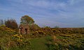
Caratacus Stone, showing the inscription CARAACI NEPVS
Location Winsford Hill, Exmoor, Somerset, England
Coordinates 51°05′26″N3°35′12″W / 51.090527°N 3.586698°W / 51.090527; -3.586698
OS grid reference SS88973355
Built Sub-Roman period (approximately sixth century)
Official nameCaratacus Stone
Reference no.1021228 [1]
Somerset UK location map.svg
Red pog.svg
Location of Caratacus Stone in Somerset

The Caratacus Stone, sometimes known as the Caractacus Stone, is an inscribed stone on Exmoor in Somerset, England. It is thought to date from the 6th century, [2] and it has been a scheduled monument since 1925. [1]

Contents

The inscription, in Latin, appears to read CARAACI NEPVS, [2] though experts have stated that a bar above the second A forms a ligature meaning that it should be read as CARATACI NEPVS. [3] [4] It is possible that there was more text on the stone that has weathered away. [2]

The inscription, which can be translated as "grandson or immediate descendant of Caratacus", [3] has led to the general opinion that the stone was probably erected as a memorial to a person who claimed the first-century British chieftain Caratacus as an ancestor. [2]

The first mention of the stone was in 1219, when it was described in a perambulation of the Royal Forest of Exmoor as "the Langeston". [2] In 1890 the letter N (which is reversed) was missing from the inscription, but by 1919 the missing piece had been found and was cemented back in place. [4] In 1906 a shelter was erected over the stone, and an excavation in 1937 revealed that the stone was not associated with a burial site. [2]

Related Research Articles

<span class="mw-page-title-main">Exmoor</span> National park in South West England

Exmoor is loosely defined as an area of hilly open moorland in west Somerset and north Devon in South West England. It is named after the River Exe, the source of which is situated in the centre of the area, two miles north-west of Simonsbath. Exmoor is more precisely defined as the area of the former ancient royal hunting forest, also called Exmoor, which was officially surveyed 1815–1818 as 18,810 acres (7,610 ha) in extent. The moor has given its name to a National Park, which includes the Brendon Hills, the East Lyn Valley, the Vale of Porlock and 55 km (34 mi) of the Bristol Channel coast. The total area of the Exmoor National Park is 692.8 km2 (267.5 sq mi), of which 71% is in Somerset and 29% in Devon.

<span class="mw-page-title-main">Dulverton</span> Human settlement in England

Dulverton is a town and civil parish in west Somerset, England, near the border with Devon. The town had a population of 1,408 at the 2011 Census. The parish includes the hamlets of Battleton and Ashwick which is located approximately 4 miles (6.4 km) north west of Dulverton.

<span class="mw-page-title-main">History of Somerset</span> Aspect of history

Somerset is a historic county in the south west of England. There is evidence of human occupation since prehistoric times with hand axes and flint points from the Palaeolithic and Mesolithic eras, and a range of burial mounds, hill forts and other artefacts dating from the Neolithic, Bronze and Iron Ages. The oldest dated human road work in Great Britain is the Sweet Track, constructed across the Somerset Levels with wooden planks in the 39th century BCE.

<span class="mw-page-title-main">Dunster</span> Human settlement in England

Dunster is a village and civil parish in Somerset, England, within the north-eastern boundary of Exmoor National Park. It lies on the Bristol Channel 2.5 miles (4 km) southeast of Minehead and 20 miles (32 km) northwest of Taunton. At the 2011 Census, it had a population of 817.

<span class="mw-page-title-main">Dunkery Hill</span> Summit of Dunkery Hill

Dunkery Beacon at the summit of Dunkery Hill is the highest point on Exmoor and in Somerset, England. It is also the highest point in southern England outside of Dartmoor.

<span class="mw-page-title-main">Geology of Somerset</span>

Somerset is a rural county in the southwest of England, covering 4,171 square kilometres (1,610 sq mi). It is bounded on the north-west by the Bristol Channel, on the north by Bristol and Gloucestershire, on the north-east by Wiltshire, on the south-east by Dorset, and on the south west and west by Devon. It has broad central plains with several ranges of low hills. The landscape divides into four main geological sections from the Silurian through the Devonian and Carboniferous to the Permian which influence the landscape, together with water-related features.

<span class="mw-page-title-main">Withypool</span> Human settlement in England

Withypool is a small village and former civil parish, now in the parish of Withypool and Hawkridge, in the Somerset district, in the ceremonial county of Somerset, England, near the centre of Exmoor National Park and close to the border with Devon. The word Withy means "willow". The parish of Withypool and Hawkridge, covers 3,097 hectares, includes the village of Hawkridge and has a population around 201.

<span class="mw-page-title-main">River Barle</span> River in Somerset and Devon, England

The River Barle runs from the Chains on northern Exmoor, in Somerset, England to join the River Exe at Exebridge, Devon. The river and the Barle Valley are both designated as biological Sites of Special Scientific Interest.

<span class="mw-page-title-main">Holnicote Estate</span> Estate in Selworthy, England

Holnicote in the parish of Selworthy, West Somerset, England, is a historic estate consisting of 12,420 acres of land, much situated within the Exmoor National Park.

<span class="mw-page-title-main">Exford, Somerset</span> Human settlement in England

Exford is a rural village at the centre of Exmoor National Park, 7 miles (11 km) north-west of Dulverton, and 10 miles (16 km) south-west of Minehead, in Somerset, England. Less than a mile away is the hamlet of Lyncombe.

<span class="mw-page-title-main">Old Cleeve</span> Human settlement in England

Old Cleeve is a village 5 miles (8 km) south east of Minehead in the Somerset West and Taunton district of Somerset, England, and also a civil parish. The civil parish of Old Cleeve covers an area of 2,092 hectares and includes the villages of Old Cleeve, Roadwater and Washford as well as hamlets such as Bilbrook, Chapel Cleeve, Golsoncott and Leighland Chapel. Approximately half the parish lies within the Exmoor National Park. The remaining half is on the southern edge of Exmoor. The village has been in existence since the early 13th century. The village held its first council meeting in 1711. By the 1720s the village had several churches, in which to meet. The town hall was built in 1727. The first church here was built in 1694, built by the Eastern Christian Society. This church was destroyed in a fire in 1847, and has been rebuilt and restored. In 2011, the population of the parish was 1,672.

<span class="mw-page-title-main">Winsford, Somerset</span> Human settlement in England

Winsford is a village and civil parish in Somerset, England, located about 5 miles (8 km) north-west of Dulverton.

<span class="mw-page-title-main">Selworthy</span> Village in Somerset, England

Selworthy is a small village and civil parish 5 kilometres (3 mi) from Minehead in Somerset, England. It is located in the National Trust's Holnicote Estate on the northern fringes of Exmoor. The parish includes the hamlets of Bossington, Tivington, Lynch, Brandish Street and Allerford.

<span class="mw-page-title-main">Gallox Bridge, Dunster</span> Bridge in Somerset, England

The Gallox Bridge in Dunster, Somerset, England dates from the 15th century. It has been designated as a Grade I listed building and scheduled monument. The bridge is in the guardianship of English Heritage.

<span class="mw-page-title-main">Dunster Butter Cross</span> Market cross in Dunster, Somerset, UK

The Butter Cross in Dunster within the English county of Somerset is a Grade II* listed building and scheduled monument. The cross was originally erected in the late 14th or early 15th century in the main street, and was moved to its current site in the late 18th or early 19th century. Although the head of the cross is missing, the shaft and socket stone are original. The cross is in the care of English Heritage and is managed by the National Trust.

<span class="mw-page-title-main">Scheduled monuments in Somerset</span> Nationally important sites in Somerset, England

There are over 670 scheduled monuments in the ceremonial county of Somerset in South West England. The county consists of a non-metropolitan county, administered by Somerset Council. The two administratively independent unitary authorities, which were established on 1 April 1996 following the breakup of the county of Avon, are North Somerset and Bath and North East Somerset. These unitary authorities include areas that were once part of Somerset before the creation of Avon in 1974.

<span class="mw-page-title-main">Haddon Hill</span>

Haddon Hill is a prominent east–west aligned ridge in west Somerset, England, close to Hartford within the civil parish of Brompton Regis. It lies on the south-eastern fringe of Exmoor National Park though is separated from the Exmoor massif itself by the valleys of the rivers Haddeo and Exe The highest point of the ridge at OS grid reference SS 962286 is crowned by a trig point at 1,164 feet (355 m) above sea level. Much of the upper part of the hill is mapped as open access under the Countryside and Rights of Way Act 2000 and hence available for public access on foot. A couple of public footpaths traverse the hill north–south whilst numerous tracks run along its length. The larger part of the hill is within the national park, the boundary of which runs along the B3190 road which runs diagonally across the eastern end of the ridge en route from Watchet to Bampton. Vehicular access is available off this road. The hill affords views across Wimbleball Reservoir which occupies the Haddeo valley immediately to its north.

<span class="mw-page-title-main">Porlock Stone Circle</span> Neolithic stone circle in Somerset, England

Porlock Stone Circle is a stone circle located on Exmoor, near the village of Porlock in the south-western English county of Somerset. The Porlock ring is part of a tradition of stone circle construction that spread throughout much of Britain, Ireland, and Brittany during the Late Neolithic and Early Bronze Age, over a period between 3300 and 900 BCE. The purpose of such monuments is unknown, although archaeologists speculate that the stones represented supernatural entities for the circles' builders.

<span class="mw-page-title-main">Withypool Stone Circle</span> Late neolithic stone circle in Somerset, England

Withypool Stone Circle, also known as Withypool Hill Stone Circle, is a stone circle located on the Exmoor moorland, near the village of Withypool in the southwestern English county of Somerset. The ring is part of a tradition of stone circle construction that spread throughout much of Britain, Ireland, and Brittany during the Late Neolithic and Early Bronze Age, over a period between 3300 and 900 BCE. The purpose of such monuments is unknown, although archaeologists speculate that the stones represented supernatural entities for the circle's builders.

West Somerset was a local government district in the English county of Somerset. It merged with Taunton Deane to form Somerset West and Taunton on 1 April 2019.

References

  1. 1 2 Historic England. "Caratacus Stone (1021228)". National Heritage List for England . Retrieved 9 June 2013.
  2. 1 2 3 4 5 6 Historic England. "Caratacus Stone (35777)". Research records (formerly PastScape). Retrieved 3 June 2011.
  3. 1 2 Thomas, Charles (1994). And Shall These Mute Stones Speak? Post Roman Inscriptions in Western Britain. University of Wales Press. pp. 288–9. ISBN   0-7083-1160-1.
  4. 1 2 Bruton, F. A. (1919). "The Caratacus Stone on Exmoor" (PDF). The Journal of Roman Studies. 9: 208–210. doi:10.2307/296006.

Commons-logo.svg Media related to Caratacus Stone at Wikimedia Commons