Related Research Articles

Oil sands, tar sands, crude bitumen, or bituminous sands, are a type of unconventional petroleum deposit. Oil sands are either loose sands or partially consolidated sandstone containing a naturally occurring mixture of sand, clay, and water, soaked with bitumen, a dense and extremely viscous form of petroleum.

Coalbed methane, coalbed gas, or coal seam gas (CSG) is a form of natural gas extracted from coal beds. In recent decades it has become an important source of energy in United States, Canada, Australia, and other countries.

Carbon is a village in central Alberta, Canada.

Nordegg is a hamlet in west-central Alberta, Canada within Clearwater County. It is in the North Saskatchewan River valley in the foothills of the Canadian Rockies, just east of the intersection of the David Thompson Highway and the Highway 734 spur of the Bighorn Highway. A former coal mining town, it was named after Martin Nordegg and the name probably means "North Corner" in a German dialect. The railway station name at the locality was called Brazeau rather than Nordegg at certain points in its history, but the local post office has always been named Nordegg. The name Brazeau is now obsolete.
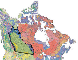
The Western Canadian Sedimentary Basin (WCSB) underlies 1.4 million square kilometres (540,000 sq mi) of Western Canada including southwestern Manitoba, southern Saskatchewan, Alberta, northeastern British Columbia and the southwest corner of the Northwest Territories. This vast sedimentary basin consists of a massive wedge of sedimentary rock extending from the Rocky Mountains in the west to the Canadian Shield in the east. This wedge is about 6 kilometres (3.7 mi) thick under the Rocky Mountains, but thins to zero at its eastern margins. The WCSB contains one of the world's largest reserves of petroleum and natural gas and supplies much of the North American market, producing more than 450 million cubic metres per day of gas in 2000. It also has huge reserves of coal. Of the provinces and territories within the WCSB, Alberta has most of the oil and gas reserves and almost all of the oil sands.

Canada has access to all main sources of energy including oil and gas, coal, hydropower, biomass, solar, geothermal, wind, marine and nuclear. It is the world's second largest producer of uranium, third largest producer of hydro-electricity, fourth largest natural gas producer, and the fifth largest producer of crude oil. In 2006, only Russia, the People's Republic of China, the United States and Saudi Arabia produce more total energy than Canada.
Coal reserves in Canada rank 13th largest in the world at approximately 10 billion tons, 0.6% of the world total. This represents more energy than all of the oil and gas in the country combined. The coal industry generates CDN$5 billion annually. Most of Canada's coal mining occurs in the West of the country. British Columbia operates 9 coal mines, Alberta nine, Saskatchewan three and New Brunswick one. Nova Scotia operates several small-scale mines, Westray having closed following the 1992 disaster there.
Carbondale is a hamlet in central Alberta, Canada within Sturgeon County. It is located 2 kilometres (1.2 mi) west of Highway 28, approximately 11 kilometres (6.8 mi) north of Edmonton's city limits.

The Beaver Lake Cree Nation is a First Nations band government located 105 kilometres (65 mi) northeast of Edmonton, Alberta, representing people of the Cree ethno-linguistic group in the area around Lac La Biche, Alberta, where the band office is currently located. Their treaty area is Treaty 6. The Intergovernmental Affairs office consults with persons on the Government treaty contacts list. There are two parcels of land reserved for the band by the Canadian Crown, Beaver Lake Indian Reserve No. 131 and Blue Quills First Nation Indian Reserve. The latter reserve is shared by six bands; Beaver Lake Cree Nations, Cold Lake First Nations, Frog Lake First Nation, Heart Lake First Nation, Kehewin Cree Nation, Saddle Lake Cree Nation.
The Ardley is a large coal field located in the western part of Canada in Alberta. Ardley represents one of the largest coal reserve in Canada having estimated reserves of 596 billion tonnes of coal.
The Drumheller is a large coal field located in the western part of Canada in Alberta. Drumheller represents one of the largest coal reserve in Canada having estimated reserves of 564 billion tonnes of coal.
The Mannville is a large coal field located in the western part of Canada in Alberta. Mannville represents one of the largest coal reserve in Canada having estimated reserves of 570 billion tonnes of coal.
The MacKay is a large coal field located in the western part of Canada in Alberta. MacKay represents one of the largest coal reserve in Canada having estimated reserves of 403 billion tonnes of coal.
The Taber is a large coal field located in the western part of Canada in Alberta. Taber represents one of the largest coal reserve in Canada having estimated reserves of 335 billion tonnes of coal.
The Lethbridge is a large coal field located in the western part of Canada in Alberta. Lethbridge represents one of the largest coal reserve in Canada having estimated reserves of 277 billion tonnes of coal.
The Daly-Weaver is a large coal field located in the western part of Canada in Alberta. Daly-Weaver represents one of the largest coal reserve in Canada having estimated reserves of 178 billion tonnes of coal.
The Gething is a large coal field located in the western part of Canada in Alberta. Gething represents one of the largest coal reserve in Canada having estimated reserves of 13 billion tonnes of coal.
Carbon pricing in Canada is implemented either as a regulatory fee or tax levied on the carbon content of fuels at the Canadian provincial, territorial or federal level. Provinces and territories of Canada are allowed to create their own system of carbon pricing as long as they comply with the minimum requirements set by the federal government; individual provinces and territories thus may have a higher tax than the federally mandated one but not a lower one. Currently, all provinces and territories are subject to a carbon pricing mechanism, either by an in-province program or by one of two federal programs. As of April 2023 the federal minimum tax is set at CA$65 per tonne of CO2 equivalent, set to increase to CA$170 in 2030.
The Canadian province of Alberta faces a number of environmental issues related to natural resource extraction—including oil and gas industry with its oil sands—endangered species, melting glaciers in banff, floods and droughts, wildfires, and global climate change. While the oil and gas industries generates substantial economic wealth, the Athabasca oil sands, which are situated almost entirely in Alberta, are the "fourth most carbon intensive on the planet behind Algeria, Venezuela and Cameroon" according to an August 8, 2018 article in the American Association for the Advancement of Science's journal Science. This article details some of the environmental issues including past ecological disasters in Alberta and describes some of the efforts at the municipal, provincial and federal level to mitigate the risks and impacts.
References
- ↑ "Ardley coal deposit" (PDF). alberta.ca. 2012. Archived from the original (PDF) on 2013-09-13. Retrieved 2013-07-23.
| | This Alberta location article is a stub. You can help Wikipedia by expanding it. |
| | This article about a specific mine is a stub. You can help Wikipedia by expanding it. |